


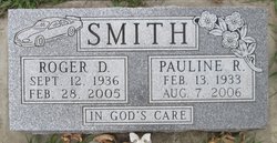
Pauline Ray “Polly” Taylor Smith
| Birth | : | 13 Feb 1933 Salt Lake City, Salt Lake County, Utah, USA |
| Death | : | 7 Aug 2006 Watertown, Codington County, South Dakota, USA |
| Burial | : | Batchelder-Nye Road Cemetery, Acworth, Sullivan County, USA |
| Coordinate | : | 43.2134018, -72.2925186 |
| Description | : | Funeral services will be Thurs., Aug. 10, for Pauline "Polly" R. Smith, 73, Watertown, former Madison resident, who died on Aug. 7, 2006, at the Watertown hospital. The Rev. Ken Mund will officiate in Cornerstone United Methodist Church at Watertown, and burial will be in the Ramona Cemetery at Ramona. Polly Taylor was born on Feb. 13, 1933, at Salt Lake City, Utah, to Joseph John and Hannah (Hughes) Taylor. She married Roger Smith on July 5, 1964, at Elco, Nev. They moved to Huron, where they owned and operated Kentucky Fried Chicken, which was later changed to Dakota Style Chicken.... Read More |
frequently asked questions (FAQ):
-
Where is Pauline Ray “Polly” Taylor Smith's memorial?
Pauline Ray “Polly” Taylor Smith's memorial is located at: Batchelder-Nye Road Cemetery, Acworth, Sullivan County, USA.
-
When did Pauline Ray “Polly” Taylor Smith death?
Pauline Ray “Polly” Taylor Smith death on 7 Aug 2006 in Watertown, Codington County, South Dakota, USA
-
Where are the coordinates of the Pauline Ray “Polly” Taylor Smith's memorial?
Latitude: 43.2134018
Longitude: -72.2925186
Family Members:

Flowers:


Nearby Cemetories:
1. Batchelder-Nye Road Cemetery
Acworth, Sullivan County, USA
Coordinate: 43.2134018, -72.2925186
2. Acworth Cemetery
Acworth, Sullivan County, USA
Coordinate: 43.2129211, -72.2940216
3. Mitchell Cemetery
Acworth, Sullivan County, USA
Coordinate: 43.2188100, -72.2854000
4. Marple Cemetery
Acworth, Sullivan County, USA
Coordinate: 43.1858330, -72.2502780
5. Newton Cemetery
Acworth, Sullivan County, USA
Coordinate: 43.1730560, -72.3150000
6. Walker Farm Cemetery
Acworth, Sullivan County, USA
Coordinate: 43.2627800, -72.3066700
7. Quaker City Cemetery
Quaker City, Sullivan County, USA
Coordinate: 43.2707500, -72.3315100
8. West End Cemetery
Marlow, Cheshire County, USA
Coordinate: 43.1511917, -72.2513809
9. Gee Cemetery
Lempster, Sullivan County, USA
Coordinate: 43.1883300, -72.1963900
10. Lower Cemetery
Unity, Sullivan County, USA
Coordinate: 43.2912100, -72.2835500
11. Upper Langdon Cemetery
Langdon, Sullivan County, USA
Coordinate: 43.1675500, -72.3796200
12. Unity Center Cemetery
Unity, Sullivan County, USA
Coordinate: 43.2922200, -72.2747300
13. Maple Side Cemetery
Alstead, Cheshire County, USA
Coordinate: 43.1495100, -72.3592200
14. North Cemetery
Alstead, Cheshire County, USA
Coordinate: 43.1511457, -72.3631668
15. East Alstead Cemetery
East Alstead, Cheshire County, USA
Coordinate: 43.1301900, -72.2802600
16. East Lempster Cemetery
East Lempster, Sullivan County, USA
Coordinate: 43.2253700, -72.1769500
17. Pine Grove Cemetery
Alstead, Cheshire County, USA
Coordinate: 43.1493400, -72.3693200
18. Lower Langdon Cemetery
Langdon, Sullivan County, USA
Coordinate: 43.1585999, -72.3938980
19. Forest Hill Cemetery
Charlestown, Sullivan County, USA
Coordinate: 43.2374300, -72.4208000
20. Pine Crest Cemetery
Charlestown, Sullivan County, USA
Coordinate: 43.2539700, -72.4134600
21. Sullivan County Farm Cemetery
Unity, Sullivan County, USA
Coordinate: 43.3102800, -72.3111200
22. Alstead Center Cemetery
Alstead Center, Cheshire County, USA
Coordinate: 43.1177000, -72.3264000
23. Saint Catherines Cemetery
Charlestown, Sullivan County, USA
Coordinate: 43.2314800, -72.4263300
24. Marlow Early Settlers Cemetery
Marlow, Cheshire County, USA
Coordinate: 43.1285040, -72.2204730