
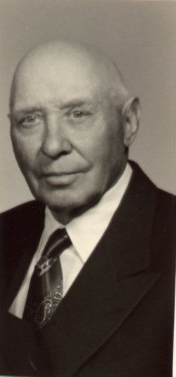
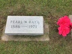
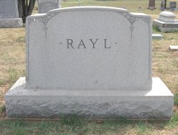
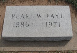
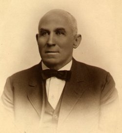
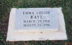
Pearl Willard Rayl
| Birth | : | 8 Aug 1886 Kingman, Kingman County, Kansas, USA |
| Death | : | 9 May 1971 Kingman, Kingman County, Kansas, USA |
| Burial | : | Harmony Grove Cemetery, Nebo, McDowell County, USA |
| Coordinate | : | 35.6653350, -81.9073650 |
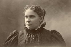
| Description | : | `Pearl was the son of Charles Rayl and Emma Julia Foutz. He married Elsie J. Marshall on 3 June 1908 at Kingman, Kansas, they had two daughters: Mary Ester and Rachael Margaret Rayl. He spent his life farming in Kingman County, Kansas. "My" final resting place will be in Old Mission Mausoleum, Wichita, Kansas, if you would like to take a visual tour just click on this link: Eternity and Me! |
frequently asked questions (FAQ):
-
Where is Pearl Willard Rayl's memorial?
Pearl Willard Rayl's memorial is located at: Harmony Grove Cemetery, Nebo, McDowell County, USA.
-
When did Pearl Willard Rayl death?
Pearl Willard Rayl death on 9 May 1971 in Kingman, Kingman County, Kansas, USA
-
Where are the coordinates of the Pearl Willard Rayl's memorial?
Latitude: 35.6653350
Longitude: -81.9073650
Family Members:
Parent
Spouse
Siblings
Children
Flowers:


Nearby Cemetories:
1. Harmony Grove Cemetery
Nebo, McDowell County, USA
Coordinate: 35.6653350, -81.9073650
2. Bradley Family Cemetery - Nebo
McDowell County, USA
Coordinate: 35.6475900, -81.8999100
3. Hillcrest Cemetery
Nebo, McDowell County, USA
Coordinate: 35.6842850, -81.9070230
4. Living Waters Cemetery
McDowell County, USA
Coordinate: 35.6480160, -81.8956420
5. Rocky Pass Freewill Baptist Church Cemetery
Osborne Knob, McDowell County, USA
Coordinate: 35.6492004, -81.9255981
6. Dixon Cemetery
McDowell County, USA
Coordinate: 35.6507988, -81.8861008
7. Faith Mission Baptist Church Cemetery
McDowell County, USA
Coordinate: 35.6653820, -81.9352920
8. Old Tate Cemetery
McDowell County, USA
Coordinate: 35.6798630, -81.8800230
9. Fairview Freewill Baptist Church Cemetery
Nebo, McDowell County, USA
Coordinate: 35.6885680, -81.9265200
10. Revis Cemetery
McDowell County, USA
Coordinate: 35.6753740, -81.9410790
11. Pinnacle Methodist Church Cemetery
Nebo, McDowell County, USA
Coordinate: 35.6492200, -81.8747900
12. Muddy Creek Baptist
McDowell County, USA
Coordinate: 35.6871190, -81.8784670
13. Dysartsville Church of Christ Cemetery
Marion, McDowell County, USA
Coordinate: 35.6354600, -81.8890800
14. Hemphill Cemetery
McDowell County, USA
Coordinate: 35.7004480, -81.9014470
15. Pinnacle Baptist Church Cemetery
McDowell County, USA
Coordinate: 35.6984700, -81.8856700
16. Sunny Grove Baptist Church Cemetery
McDowell County, USA
Coordinate: 35.6271870, -81.8957620
17. Pleasant Hill United Methodist Church Cemetery
Marion, McDowell County, USA
Coordinate: 35.6677690, -81.9572040
18. Drucilla Independent Fundamental Cemetery
Dysartsville, McDowell County, USA
Coordinate: 35.6285700, -81.8821900
19. Solid Rock Free Will Baptist Church Cemetery
Marion, McDowell County, USA
Coordinate: 35.6693120, -81.9589280
20. Gardin-Haney Cemetery
McDowell County, USA
Coordinate: 35.6303270, -81.9400350
21. Haney Cemetery
McDowell County, USA
Coordinate: 35.6293983, -81.9400024
22. Saint John AME Church Cemetery
McDowell County, USA
Coordinate: 35.7058105, -81.8838196
23. Trinity Hill Freewill Baptist Church
McDowell County, USA
Coordinate: 35.7103500, -81.8955612
24. Salem Freewill Baptist Church Cemetery
Old Fort, McDowell County, USA
Coordinate: 35.7104460, -81.8954030