

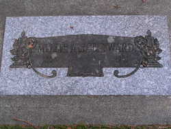
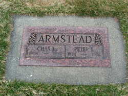
Peter Lewis Armstead
| Birth | : | 3 Mar 1874 Port Huron, St. Clair County, Michigan, USA |
| Death | : | 22 Sep 1956 Chelan, Chelan County, Washington, USA |
| Burial | : | Wessington Cemetery, Hand County, USA |
| Coordinate | : | 44.4569016, -98.7102966 |
| Plot | : | North Fraternal Row49 BLK51 L4A |
| Inscription | : | Charles L Armstead |
| Description | : | Peter Lewis Armstead, pioneer resident of Lakeside, died Sunday following an extended illness. Mr. Armstead was born Mar. 3, 1874, in Port Huron, Michigan. He homesteaded on a farm near Leeds, North Dakota and later moved to Morehead, Minn. He was married to Irene Pavitt in Morehead, Minn., in 1907. To this union were born three children, Charles Lewis Armstead of Chelan, Mrs. Hazel Eleanor Marshall of Walla Walla, and Mrs. Kathryn Mary La Bounty of New York City. The family came to Lakeside in 1908 and made their home there with the exception of a few years when they... Read More |
frequently asked questions (FAQ):
-
Where is Peter Lewis Armstead's memorial?
Peter Lewis Armstead's memorial is located at: Wessington Cemetery, Hand County, USA.
-
When did Peter Lewis Armstead death?
Peter Lewis Armstead death on 22 Sep 1956 in Chelan, Chelan County, Washington, USA
-
Where are the coordinates of the Peter Lewis Armstead's memorial?
Latitude: 44.4569016
Longitude: -98.7102966
Family Members:
Parent
Siblings
Children
Flowers:


Nearby Cemetories:
1. Wessington Cemetery
Hand County, USA
Coordinate: 44.4569016, -98.7102966
2. Saint Josephs Catholic Cemetery
Hand County, USA
Coordinate: 44.4574400, -98.7100400
3. McCord Cemetery
Wessington, Beadle County, USA
Coordinate: 44.3998500, -98.6673100
4. Sand Creek Cemetery
Beadle County, USA
Coordinate: 44.3055800, -98.6791200
5. Beulah Cemetery
Vayland, Hand County, USA
Coordinate: 44.6060982, -98.8060989
6. Saint Johns Lutheran Cemetery
Wolsey, Beadle County, USA
Coordinate: 44.3927994, -98.4985962
7. Rosehill Cemetery
Hand County, USA
Coordinate: 44.2980995, -98.7731018
8. Saint Lawrence Cemetery
Saint Lawrence, Hand County, USA
Coordinate: 44.5292015, -98.9321976
9. Wolsey Cemetery
Wolsey, Beadle County, USA
Coordinate: 44.4000015, -98.4546967
10. Saint Ann's Cemetery
Miller, Hand County, USA
Coordinate: 44.5222015, -98.9732971
11. G A R Cemetery
Miller, Hand County, USA
Coordinate: 44.5078011, -98.9858017
12. Bonilla Cemetery
Bonilla, Beadle County, USA
Coordinate: 44.5830994, -98.4835968
13. Molvig Cemetery
Virgil, Beadle County, USA
Coordinate: 44.2552900, -98.6145900
14. Hillcrest Cemetery
Miller, Hand County, USA
Coordinate: 44.5207000, -99.0006100
15. Garfield Cemetery
Spink County, USA
Coordinate: 44.6622009, -98.5535965
16. Buffalo Cemetery
Spink County, USA
Coordinate: 44.6918983, -98.6853027
17. Sunbeam Cemetery
Hand County, USA
Coordinate: 44.6777992, -98.8407974
18. Burdette Cemetery
Burdette, Hand County, USA
Coordinate: 44.7002983, -98.7869034
19. Earlville Cemetery
Beadle County, USA
Coordinate: 44.2118988, -98.6091995
20. Altoona Cemetery
Hitchcock, Beadle County, USA
Coordinate: 44.6108017, -98.4113998
21. New Zion Cemetery
Hand County, USA
Coordinate: 44.2043991, -98.8206024
22. Saint Johns Cemetery
Tulare, Spink County, USA
Coordinate: 44.7202988, -98.6600037
23. Virgil Cemetery
Virgil, Beadle County, USA
Coordinate: 44.2904800, -98.4176700
24. Broadland Catholic Cemetery
Broadland, Beadle County, USA
Coordinate: 44.5005000, -98.3380800