
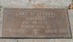
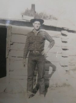
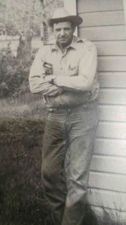
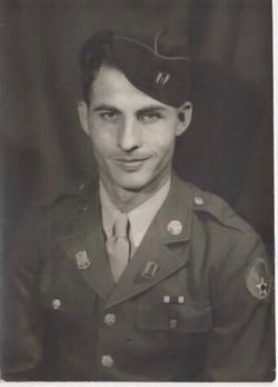
PFC Carl Owen Jerrel
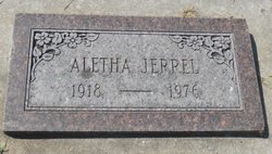
| Birth | : | 1 Jan 1918 Carter County, Montana, USA |
| Death | : | 8 Aug 1972 Garfield County, Montana, USA |
| Burial | : | Calvary Cemetery, Miles City, Custer County, USA |
| Coordinate | : | 46.3816986, -105.8249969 |
| Plot | : | Section LN: Lot 85 |
| Inscription | : | MONTANA PFC US ARMY WORLD WAR II |
| Description | : | SOURCE: Death Certificate: '''''''''''''''''''''''' Great Falls Tribune, MT. 8/11/1972 Friday Page 7 MILES CITY, MT. --- Carl O. Jerrel, 54 died |
frequently asked questions (FAQ):
-
Where is PFC Carl Owen Jerrel's memorial?
PFC Carl Owen Jerrel's memorial is located at: Calvary Cemetery, Miles City, Custer County, USA.
-
When did PFC Carl Owen Jerrel death?
PFC Carl Owen Jerrel death on 8 Aug 1972 in Garfield County, Montana, USA
-
Where are the coordinates of the PFC Carl Owen Jerrel's memorial?
Latitude: 46.3816986
Longitude: -105.8249969
Family Members:
Parent

Spouse
Siblings
Children

Flowers:


Nearby Cemetories:
1. Calvary Cemetery
Miles City, Custer County, USA
Coordinate: 46.3816986, -105.8249969
2. Old Calvary Cemetery
Miles City, Custer County, USA
Coordinate: 46.3807600, -105.8246500
3. Eastern Montana State Veterans Cemetery
Miles City, Custer County, USA
Coordinate: 46.3807564, -105.8246536
4. Custer County Cemetery
Miles City, Custer County, USA
Coordinate: 46.3891983, -105.8264008
5. Pine Hills School Cemetery
Miles City, Custer County, USA
Coordinate: 46.4077988, -105.8167038
6. Fort Keogh Cemetery
Custer County, USA
Coordinate: 46.3800011, -105.8874969
7. Pine Crest Cemetery
Custer County, USA
Coordinate: 46.4564018, -105.7789001
8. Hathaway Cemetery
Rosebud County, USA
Coordinate: 46.2616997, -106.2185974
9. Rosebud Cemetery
Rosebud, Rosebud County, USA
Coordinate: 46.2689018, -106.4381027
10. Powder River Supply Depot Cemetery
Terry, Prairie County, USA
Coordinate: 46.7302900, -105.4350800
11. Rock Springs Cemetery
Rock Springs, Rosebud County, USA
Coordinate: 46.7847800, -106.1411500
12. MacKenzie Family Cemetery
Custer County, USA
Coordinate: 46.1569500, -105.1448000
13. Prairie County Cemetery
Terry, Prairie County, USA
Coordinate: 46.7881012, -105.3443985
14. Knowlton Cemetery
Custer County, USA
Coordinate: 46.3210983, -105.0710983
15. Little Flat Community Cemetery
Fallon, Prairie County, USA
Coordinate: 46.4598000, -105.0291700
16. Forsyth Cemetery
Forsyth, Rosebud County, USA
Coordinate: 46.2689018, -106.6528015
17. Cottonwood Cemetery
Custer County, USA
Coordinate: 46.4294014, -104.9674988
18. North Stacey Cemetery
Powder River County, USA
Coordinate: 45.7569008, -105.8814011
19. Fallon Cemetery
Prairie County, USA
Coordinate: 46.8168983, -105.1327972
20. Little Flat Community Cemetery
Fallon, Prairie County, USA
Coordinate: 46.7659300, -105.0487600
21. Bean Cemetery
Rosebud County, USA
Coordinate: 45.8535995, -106.4011002
22. Lutheran Cemetery
Fallon, Prairie County, USA
Coordinate: 46.8320800, -105.1120100
23. Mildred Cemetery
Mildred, Prairie County, USA
Coordinate: 46.6850204, -104.9543457
24. Brown Cemetery
Colstrip, Rosebud County, USA
Coordinate: 45.8321991, -106.4180984