
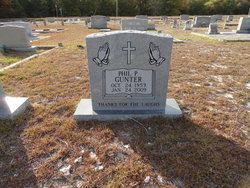
Phil Pree Gunter
| Birth | : | 23 Oct 1953 Columbia, Lexington County, South Carolina, USA |
| Death | : | 24 Jan 2009 Lexington County, South Carolina, USA |
| Burial | : | Lakeside Cemetery, Colon, St. Joseph County, USA |
| Coordinate | : | 41.9667015, -85.3364029 |
| Description | : | He was a resident of Gilbert, SC. Survivors include his brothers, William T. Gunter, Charles M. Gunter, Lynwood B. Gunter, Lewis V. Gunter, Bobby R. Gunter, & Donald Ray Gunter; sister, Margaret Mims. He was preceded in death by his parents, Lewis Edward & Rosa Lee Burkett Gunter; brothers, Vernon Gunter & Floyd Gunter; sister, Margie Lucas. Graveside services were conducted on Friday, January 30, 2009. Pallbearers were Bruce, Bryan, Charlie, Pete, Shelton, & Vernon Gunter. |
frequently asked questions (FAQ):
-
Where is Phil Pree Gunter's memorial?
Phil Pree Gunter's memorial is located at: Lakeside Cemetery, Colon, St. Joseph County, USA.
-
When did Phil Pree Gunter death?
Phil Pree Gunter death on 24 Jan 2009 in Lexington County, South Carolina, USA
-
Where are the coordinates of the Phil Pree Gunter's memorial?
Latitude: 41.9667015
Longitude: -85.3364029
Family Members:
Parent


Siblings


Flowers:


Nearby Cemetories:
1. Lakeside Cemetery
Colon, St. Joseph County, USA
Coordinate: 41.9667015, -85.3364029
2. Colon United Methodist Church Columbarium
Colon, St. Joseph County, USA
Coordinate: 41.9598940, -85.3245500
3. McAuley Cemetery
Leonidas Township, St. Joseph County, USA
Coordinate: 41.9916992, -85.3450012
4. Banta Cemetery
Leonidas, St. Joseph County, USA
Coordinate: 41.9922220, -85.3125000
5. Covey Road Amish Cemetery
Leonidas, St. Joseph County, USA
Coordinate: 41.9990290, -85.3613490
6. South Colon Cemetery
Colon, St. Joseph County, USA
Coordinate: 41.9199982, -85.3114014
7. Babcock Cemetery
Sturgis, St. Joseph County, USA
Coordinate: 41.9336014, -85.4103012
8. Blossom Road Cemetery
Sherwood Township, Branch County, USA
Coordinate: 42.0160380, -85.2737760
9. Laird Cemetery
Mendon, St. Joseph County, USA
Coordinate: 41.9841690, -85.4358292
10. Locust Grove Cemetery
Findley, St. Joseph County, USA
Coordinate: 41.8972206, -85.3799973
11. Sprung Cemetery
Mendon, St. Joseph County, USA
Coordinate: 42.0213889, -85.4194444
12. Sherwood Cemetery
Sherwood, Branch County, USA
Coordinate: 42.0066660, -85.2386110
13. Leonidas Cemetery
Leonidas, St. Joseph County, USA
Coordinate: 42.0330000, -85.4100000
14. Factoryville Cemetery
Factoryville, St. Joseph County, USA
Coordinate: 42.0505560, -85.3069460
15. Pilgrim Fellowship Cemetery
Nottawa, St. Joseph County, USA
Coordinate: 41.9190100, -85.4443810
16. Nottawa Cemetery
Nottawa, St. Joseph County, USA
Coordinate: 41.9049988, -85.4330978
17. Sanborn Cemetery
Burr Oak, St. Joseph County, USA
Coordinate: 41.8708000, -85.3305969
18. Saint Edward Cemetery
Mendon, St. Joseph County, USA
Coordinate: 42.0083350, -85.4555580
19. Pioneer Cemetery
Nottawa, St. Joseph County, USA
Coordinate: 41.9550018, -85.4710999
20. Matteson Cemetery
Matteson, Branch County, USA
Coordinate: 41.9406013, -85.2046967
21. Beard Cemetery
Leonidas, St. Joseph County, USA
Coordinate: 42.0711090, -85.3916700
22. Mendon Township Cemetery
Mendon, St. Joseph County, USA
Coordinate: 42.0052986, -85.4807968
23. North Sherwood Cemetery
Sherwood, Branch County, USA
Coordinate: 42.0611000, -85.2481003
24. Burr Oak Township Cemetery
Burr Oak, St. Joseph County, USA
Coordinate: 41.8472214, -85.3319473