
Philip DeLand
| Birth | : | 18 Aug 1724 Brookfield, Worcester County, Massachusetts, USA |
| Death | : | 11 May 1808 Brookfield, Worcester County, Massachusetts, USA |
| Burial | : | Brookfield Cemetery, Brookfield, Worcester County, USA |
| Coordinate | : | 42.2181015, -72.1156006 |
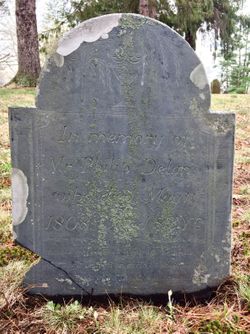
| Inscription | : | In memory of Mr. Philip Delan, who died May 11th 1808, Aged 83 Yrs. Humble and meek a lowly path he trod, and while he liv'd on earth he walked with God. Good without show, Obliging |
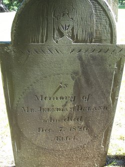
| Description | : | NOTE: Headstone says Philip Delan Philip DeLand was the first of seven children born to Paul and Phoebe GREEN DeLand. He married Lucy KILBOURN on February 1, 1762. They had six children: 1) Jedediah b. 1762, d. 1826 N. Brookfield ....m. Persis GREGORY d. 1834 Brookfield 2) Rufus b. 1764 d. 1854 Rutland, Vermont ....m. Lucy ALVORD d. 1806 Rutland, Vermont ....m. Ama PITKIN d. 1858 3) Miriam b. 1767 d. 1853 N. Brookfield 4) Charles b. 1770 d. 1845 N. Brookfield ....m. Lucy BARNES d. 1829 Brookfield 5) James b. 1774 d. 1777 Brookfield 6) Philip b. 1776... Read More |
frequently asked questions (FAQ):
-
Where is Philip DeLand's memorial?
Philip DeLand's memorial is located at: Brookfield Cemetery, Brookfield, Worcester County, USA.
-
When did Philip DeLand death?
Philip DeLand death on 11 May 1808 in Brookfield, Worcester County, Massachusetts, USA
-
Where are the coordinates of the Philip DeLand's memorial?
Latitude: 42.2181015
Longitude: -72.1156006
Family Members:
Parent

Spouse
Siblings
Children
Flowers:


Nearby Cemetories:
1. Brookfield Cemetery
Brookfield, Worcester County, USA
Coordinate: 42.2181015, -72.1156006
2. Pine Grove Cemetery
West Brookfield, Worcester County, USA
Coordinate: 42.2382960, -72.1406610
3. Old Indian Cemetery
West Brookfield, Worcester County, USA
Coordinate: 42.2372600, -72.1456500
4. Sacred Heart Cemetery
West Brookfield, Worcester County, USA
Coordinate: 42.2334900, -72.1517300
5. Old West Brookfield Road Cemetery
North Brookfield, Worcester County, USA
Coordinate: 42.2545500, -72.1137600
6. Walnut Grove Cemetery
North Brookfield, Worcester County, USA
Coordinate: 42.2629550, -72.0711060
7. North Brookfield Cemetery
North Brookfield, Worcester County, USA
Coordinate: 42.2698940, -72.0862130
8. Evergreen Cemetery
East Brookfield, Worcester County, USA
Coordinate: 42.2291985, -72.0408020
9. Cotter Cemetery
North Brookfield, Worcester County, USA
Coordinate: 42.2771988, -72.1141968
10. Pine Grove Cemetery
Warren, Worcester County, USA
Coordinate: 42.2097015, -72.1971970
11. South Warren Cemetery
Warren, Worcester County, USA
Coordinate: 42.1609300, -72.1461700
12. Saint Joseph Cemetery
North Brookfield, Worcester County, USA
Coordinate: 42.2792015, -72.0935974
13. Saint Pauls Cemetery
Warren, Worcester County, USA
Coordinate: 42.2069016, -72.1999969
14. Taylor Cemetery
West Brookfield, Worcester County, USA
Coordinate: 42.2695300, -72.1839700
15. Podunk Cemetery
East Brookfield, Worcester County, USA
Coordinate: 42.1767006, -72.0318985
16. Holy Rosary Cemetery
Spencer, Worcester County, USA
Coordinate: 42.2366982, -72.0124969
17. Little Alum Pond Cemetery
Brimfield, Hampden County, USA
Coordinate: 42.1362750, -72.1537020
18. Pine Grove Cemetery
Spencer, Worcester County, USA
Coordinate: 42.2542000, -72.0083008
19. Southwest Cemetery
New Braintree, Worcester County, USA
Coordinate: 42.3046989, -72.1485977
20. Methodist Cemetery
West Brookfield, Worcester County, USA
Coordinate: 42.2833700, -72.2061400
21. Cranberry Meadow Cemetery
Charlton, Worcester County, USA
Coordinate: 42.1849100, -71.9968300
22. Hale Cemetery
New Braintree, Worcester County, USA
Coordinate: 42.3137000, -72.1174800
23. Old Spencer Cemetery
Spencer, Worcester County, USA
Coordinate: 42.2477900, -71.9890100
24. New Braintree Church Cemetery
New Braintree, Worcester County, USA
Coordinate: 42.3171577, -72.1259003