
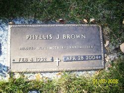
Phyllis Jeannie Stanton Brown
| Birth | : | 8 Feb 1932 Primghar, O'Brien County, Iowa, USA |
| Death | : | 28 Apr 2004 Sioux City, Woodbury County, Iowa, USA |
| Burial | : | North Lawn Cemetery, Spencer, Clay County, USA |
| Coordinate | : | 43.1600000, -95.1470000 |
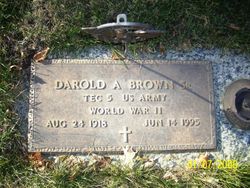
| Description | : | Phyllis Jeannie Brown, daughter of Violet Stanton Wetherell was born February 8, 1932 in Primghar. She attended school in Calumet and Sutherland. Phyllis was raised by her grandma and grandpa Stanton and was a lifelong resident of northwest Iowa. On October 6, 1947, Phyllis married Darold A. Brown in Jackson, MN. To this union six children were born. They resided in Marathon and Laurens and later in Ruthven where they made their home for many years. Phyllis owned and operated a restaurant in Marathon and later worked at the restaurant in Ruthven. She was also employed at Stubbs Ranch Kitchen in... Read More |
frequently asked questions (FAQ):
-
Where is Phyllis Jeannie Stanton Brown's memorial?
Phyllis Jeannie Stanton Brown's memorial is located at: North Lawn Cemetery, Spencer, Clay County, USA.
-
When did Phyllis Jeannie Stanton Brown death?
Phyllis Jeannie Stanton Brown death on 28 Apr 2004 in Sioux City, Woodbury County, Iowa, USA
-
Where are the coordinates of the Phyllis Jeannie Stanton Brown's memorial?
Latitude: 43.1600000
Longitude: -95.1470000
Family Members:

Spouse
Siblings
Children
Flowers:


Nearby Cemetories:
1. North Lawn Cemetery
Spencer, Clay County, USA
Coordinate: 43.1600000, -95.1470000
2. Dewey Readmore Books Memorial
Spencer, Clay County, USA
Coordinate: 43.1403999, -95.1443024
3. Riverside Cemetery
Spencer, Clay County, USA
Coordinate: 43.1441994, -95.1671982
4. Fairview Cemetery
Clay County, USA
Coordinate: 43.1899986, -95.0800018
5. Evergreen Cemetery
Clay County, USA
Coordinate: 43.2052994, -95.2086029
6. Dickens Cemetery
Dickens, Clay County, USA
Coordinate: 43.1280000, -95.0155000
7. Swedish Lutheran Cemetery
Royal, Clay County, USA
Coordinate: 43.0683000, -95.2350000
8. Little Sioux Lutheran Cemetery
Milford, Dickinson County, USA
Coordinate: 43.2702065, -95.2109528
9. Rosehill Cemetery
Clay County, USA
Coordinate: 43.0368996, -95.0919037
10. First Reformed Cemetery
Clay County, USA
Coordinate: 43.2399500, -95.2889000
11. Lone Tree Cemetery
Everly, Clay County, USA
Coordinate: 43.1411018, -95.3347015
12. Milford Cemetery
Milford, Dickinson County, USA
Coordinate: 43.3092003, -95.1481018
13. Lincoln Cemetery
Rossie, Clay County, USA
Coordinate: 43.0111008, -95.2313995
14. Calvary Cemetery
Milford, Dickinson County, USA
Coordinate: 43.3213997, -95.1688995
15. Logan Township Cemetery
Clay County, USA
Coordinate: 43.0489006, -94.9747009
16. Liberty Cemetery
Greenville, Clay County, USA
Coordinate: 42.9897003, -95.1417007
17. Willow Creek Cemetery
Royal, Clay County, USA
Coordinate: 43.0214005, -95.2885971
18. Clay Center Cemetery
Royal, Clay County, USA
Coordinate: 43.0410995, -95.3272018
19. TriMello Cemetery
Royal, Clay County, USA
Coordinate: 43.0682983, -95.3728027
20. Crown Hill Cemetery
Ruthven, Palo Alto County, USA
Coordinate: 43.1328011, -94.8878021
21. Calvary Cemetery
Ruthven, Palo Alto County, USA
Coordinate: 43.1314011, -94.8869019
22. Zion Methodist Cemetery
Clay County, USA
Coordinate: 42.9808006, -95.2497025
23. Westport Cemetery
Dickinson County, USA
Coordinate: 43.3130989, -95.3289032
24. Okoboji Cemetery
Arnolds Park, Dickinson County, USA
Coordinate: 43.3649406, -95.1303558