
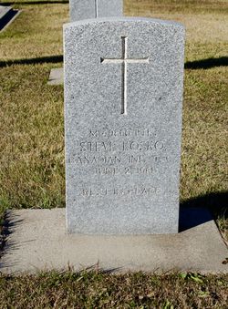
Private Stephanus “Steve” Kosko
| Birth | : | 10 Mar 1892 Lethbridge, Lethbridge Census Division, Alberta, Canada |
| Death | : | 2 Jun 1961 Drumheller, Strathmore Census Division, Alberta, Canada |
| Burial | : | Drumheller Cemetery, Drumheller, Strathmore Census Division, Canada |
| Coordinate | : | 51.4522200, -112.6920800 |
| Plot | : | 665,8 |
| Description | : | --- WWI Canadian Enlistment Papers ("Particulars of Recruit drafted under Military Service Act, 1917"): Name: Steve Kosko Regimental number: 3214931 13 M.D., First Depot Battalion, Alberta Regiment Military Service Act letter and number: 356694MO (??) Birth: 10 Mar 1892, Lethbridge, Alberta Status: Single Religion: Catholic Occupation: MIner Next-of-kin: Mrs. Annie Kosko, mother, 2nd Ave. S., Lethbridge, Alberta Presently a member of Active Militia: no Previous military or naval service: no Medical examination: 4 Sep 1918, Calgary, Alberta; category A2 Age: 26 yrs 6 mos Height: 5'7.25" Chest: fully expanded: 39", range of expansion: 4" Eyes: blue Hair: Brown Scar on... Read More |
frequently asked questions (FAQ):
-
Where is Private Stephanus “Steve” Kosko's memorial?
Private Stephanus “Steve” Kosko's memorial is located at: Drumheller Cemetery, Drumheller, Strathmore Census Division, Canada.
-
When did Private Stephanus “Steve” Kosko death?
Private Stephanus “Steve” Kosko death on 2 Jun 1961 in Drumheller, Strathmore Census Division, Alberta, Canada
-
Where are the coordinates of the Private Stephanus “Steve” Kosko's memorial?
Latitude: 51.4522200
Longitude: -112.6920800
Family Members:
Parent
Siblings
Children

Flowers:


Nearby Cemetories:
1. Drumheller Cemetery
Drumheller, Strathmore Census Division, Canada
Coordinate: 51.4522200, -112.6920800
2. Wayne Community Cemetery
Wayne, Strathmore Census Division, Canada
Coordinate: 51.3816120, -112.6602090
3. Munson Cemetery
Munson, Strathmore Census Division, Canada
Coordinate: 51.5463220, -112.7232240
4. Homeland Cemetery
Dunphy, Strathmore Census Division, Canada
Coordinate: 51.4819360, -112.8570370
5. Verdant Valley Hutterite Cemetery
Drumheller, Strathmore Census Division, Canada
Coordinate: 51.4702607, -112.4715843
6. Michichi Cemetery
Michichi, Strathmore Census Division, Canada
Coordinate: 51.5747290, -112.5357170
7. Dalum Lutheran Church Cemetery
Dalum, Strathmore Census Division, Canada
Coordinate: 51.3001500, -112.6324000
8. Hillview Hutterite Colony Cemetery
Rosebud, Strathmore Census Division, Canada
Coordinate: 51.3668406, -112.9574917
9. Knoll Hill Cemetery
Michichi, Strathmore Census Division, Canada
Coordinate: 51.6195878, -112.5181250
10. Zion Baptist Cemetery
Hesketh, Strathmore Census Division, Canada
Coordinate: 51.3876139, -113.0175028
11. Rosebud Cemetery
Rosebud, Strathmore Census Division, Canada
Coordinate: 51.3045500, -112.9581400
12. Morrin Cemetery
Morrin, Strathmore Census Division, Canada
Coordinate: 51.6775450, -112.7634160
13. Wilf Girletz Gravesite
Delia, Strathmore Census Division, Canada
Coordinate: 51.5744100, -112.3296900
14. Delia Cemetery
Delia, Strathmore Census Division, Canada
Coordinate: 51.6229700, -112.3666800
15. Neu Muehl Hutterite Cemetery
Delia, Strathmore Census Division, Canada
Coordinate: 51.4667792, -112.2634915
16. Sarcee Butte Cemetery
Drumheller, Strathmore Census Division, Canada
Coordinate: 51.6362400, -113.0056500
17. Bethel Carbon Cemetery
Carbon, Strathmore Census Division, Canada
Coordinate: 51.4164520, -113.1447840
18. Carbon Cemetery
Carbon, Strathmore Census Division, Canada
Coordinate: 51.5027520, -113.1452880
19. Rosebud Hutterite Colony Cemetery
Rockyford, Strathmore Census Division, Canada
Coordinate: 51.3134490, -113.1170667
20. Starland Colony Cemetery
Morrin, Strathmore Census Division, Canada
Coordinate: 51.7502047, -112.6044643
21. Freudental Carbon Cemetery
Carbon, Strathmore Census Division, Canada
Coordinate: 51.4165200, -113.1936200
22. Springvale Hutterite Colony Cemetery
Rockyford, Strathmore Census Division, Canada
Coordinate: 51.3193431, -113.1532530
23. Rowley Cemetery
Rowley, Strathmore Census Division, Canada
Coordinate: 51.7659000, -112.7679600
24. Wintering Hills Hutterite Colony Cemetery
Hussar, Strathmore Census Division, Canada
Coordinate: 51.1449400, -112.4919480