


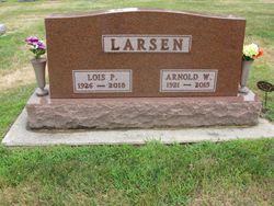
PVT Arnold William “Arnie” Larsen
| Birth | : | 27 Nov 1921 Lytton, Calhoun County, Iowa, USA |
| Death | : | 2 Nov 2015 |
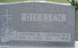
| Burial | : | Riverside Cemetery, Spencer, Clay County, USA |
| Coordinate | : | 43.1441994, -95.1671982 |
| Description | : | Army Air Corp 27 Aug 1942 Arnold "Arnie" William Larsen was called Home on November 2, 2015, at the age of 93 years, having lived at home on the farm until the last few days of his life. He was born on November 27, 1921 near Lytton, Iowa to William and Christine (Ditzel) Legge. Arnie grew up in Spencer and graduated from Spencer High School. As a self-taught radio electrician, he worked at Lockheed in California wiring military planes. When the war started, he was finally able to accomplish his goal; he gained entry into the U.S. Army... Read More |
frequently asked questions (FAQ):
-
Where is PVT Arnold William “Arnie” Larsen's memorial?
PVT Arnold William “Arnie” Larsen's memorial is located at: Riverside Cemetery, Spencer, Clay County, USA.
-
When did PVT Arnold William “Arnie” Larsen death?
PVT Arnold William “Arnie” Larsen death on 2 Nov 2015 in
-
Where are the coordinates of the PVT Arnold William “Arnie” Larsen's memorial?
Latitude: 43.1441994
Longitude: -95.1671982
Family Members:
Parent
Spouse
Siblings
Children

Flowers:


Nearby Cemetories:
1. Riverside Cemetery
Spencer, Clay County, USA
Coordinate: 43.1441994, -95.1671982
2. Dewey Readmore Books Memorial
Spencer, Clay County, USA
Coordinate: 43.1403999, -95.1443024
3. North Lawn Cemetery
Spencer, Clay County, USA
Coordinate: 43.1600000, -95.1470000
4. Evergreen Cemetery
Clay County, USA
Coordinate: 43.2052994, -95.2086029
5. Fairview Cemetery
Clay County, USA
Coordinate: 43.1899986, -95.0800018
6. Swedish Lutheran Cemetery
Royal, Clay County, USA
Coordinate: 43.0683000, -95.2350000
7. Dickens Cemetery
Dickens, Clay County, USA
Coordinate: 43.1280000, -95.0155000
8. Rosehill Cemetery
Clay County, USA
Coordinate: 43.0368996, -95.0919037
9. Lone Tree Cemetery
Everly, Clay County, USA
Coordinate: 43.1411018, -95.3347015
10. Little Sioux Lutheran Cemetery
Milford, Dickinson County, USA
Coordinate: 43.2702065, -95.2109528
11. First Reformed Cemetery
Clay County, USA
Coordinate: 43.2399500, -95.2889000
12. Lincoln Cemetery
Rossie, Clay County, USA
Coordinate: 43.0111008, -95.2313995
13. Willow Creek Cemetery
Royal, Clay County, USA
Coordinate: 43.0214005, -95.2885971
14. Liberty Cemetery
Greenville, Clay County, USA
Coordinate: 42.9897003, -95.1417007
15. Clay Center Cemetery
Royal, Clay County, USA
Coordinate: 43.0410995, -95.3272018
16. Milford Cemetery
Milford, Dickinson County, USA
Coordinate: 43.3092003, -95.1481018
17. TriMello Cemetery
Royal, Clay County, USA
Coordinate: 43.0682983, -95.3728027
18. Logan Township Cemetery
Clay County, USA
Coordinate: 43.0489006, -94.9747009
19. Zion Methodist Cemetery
Clay County, USA
Coordinate: 42.9808006, -95.2497025
20. Calvary Cemetery
Milford, Dickinson County, USA
Coordinate: 43.3213997, -95.1688995
21. Fanny Fern Cemetery
Clay County, USA
Coordinate: 42.9530983, -95.1607971
22. Crown Hill Cemetery
Ruthven, Palo Alto County, USA
Coordinate: 43.1328011, -94.8878021
23. Calvary Cemetery
Ruthven, Palo Alto County, USA
Coordinate: 43.1314011, -94.8869019
24. Westport Cemetery
Dickinson County, USA
Coordinate: 43.3130989, -95.3289032