
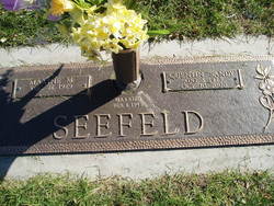
Quentin Keith “Sandy” Seefeld
| Birth | : | 3 Aug 1923 Platte County, Nebraska, USA |
| Death | : | 10 Oct 2000 Columbus, Platte County, Nebraska, USA |
| Burial | : | El Cajon Cemetery, El Cajon, San Diego County, USA |
| Coordinate | : | 32.7881012, -116.9077988 |
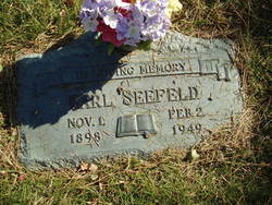
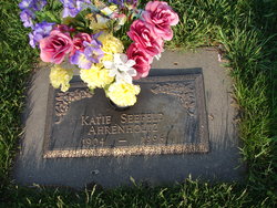
| Description | : | Son of Carl & Katie (Jelden) Seefeld. e attended grade school at Platte County District #11, graduated from Platte Center High School, Platte Center, Nebraska and attended Midland College in Fremont, Nebraska. On February 1, 1948, Quentin married Maxine Michaelson in Columbus, Nebraska. They farmed together for many years in the Madison, Nebraska area before moving back to the Columbus area where they continued to farm. Quentin, known as "Sandy" to most of his friends, enjoyed hunting, traveling, football, gardening, flowers, feeding the birds and making things with his hands. He was a member of the First Baptist Church in Columbus where... Read More |
frequently asked questions (FAQ):
-
Where is Quentin Keith “Sandy” Seefeld's memorial?
Quentin Keith “Sandy” Seefeld's memorial is located at: El Cajon Cemetery, El Cajon, San Diego County, USA.
-
When did Quentin Keith “Sandy” Seefeld death?
Quentin Keith “Sandy” Seefeld death on 10 Oct 2000 in Columbus, Platte County, Nebraska, USA
-
Where are the coordinates of the Quentin Keith “Sandy” Seefeld's memorial?
Latitude: 32.7881012
Longitude: -116.9077988
Family Members:
Parent
Spouse

Flowers:


Nearby Cemetories:
1. El Cajon Cemetery
El Cajon, San Diego County, USA
Coordinate: 32.7881012, -116.9077988
2. Singing Hills Memorial Park
El Cajon, San Diego County, USA
Coordinate: 32.7894280, -116.8891300
3. Saint Gregory of Nyssa Greek Orthodox Church
El Cajon, San Diego County, USA
Coordinate: 32.7711250, -116.9286150
4. Monument Hill Gravesite
Hillsdale, San Diego County, USA
Coordinate: 32.7722940, -116.9327470
5. Christ Church Unity Rose Garden
El Cajon, San Diego County, USA
Coordinate: 32.7925200, -116.9608200
6. Foothills United Methodist Church Columbarium
La Mesa, San Diego County, USA
Coordinate: 32.7526110, -116.9611950
7. Sycuan Indian Reservation Cemetery
El Cajon, San Diego County, USA
Coordinate: 32.7827560, -116.8373550
8. Flinn Springs Cemetery
Flinn Springs, San Diego County, USA
Coordinate: 32.8467102, -116.9213104
9. Saint Francis Xavier Cemetery
Jamul, San Diego County, USA
Coordinate: 32.7033005, -116.8707962
10. United Church of Christ Columbarium
La Mesa, San Diego County, USA
Coordinate: 32.7864100, -117.0184600
11. Alpine Mount Pisgah Pioneer Cemetery
Alpine, San Diego County, USA
Coordinate: 32.8123930, -116.7981940
12. Anton Sonka Burial Site
Lemon Grove, San Diego County, USA
Coordinate: 32.7401240, -117.0319330
13. Saint Dunstans Episcopal Church Columbarium
San Diego, San Diego County, USA
Coordinate: 32.7963070, -117.0498750
14. Alpine Cemetery
Alpine, San Diego County, USA
Coordinate: 32.8429985, -116.7664032
15. Barona Indian Cemetery
Barona, San Diego County, USA
Coordinate: 32.9341860, -116.8691150
16. Wat Lao Boubpharam Temple Columbarium
San Diego, San Diego County, USA
Coordinate: 32.7029900, -117.0574800
17. Tierrasanta Lutheran Church Memorial Garden
San Diego, San Diego County, USA
Coordinate: 32.8303840, -117.0866840
18. Beth Sarim House
San Diego, San Diego County, USA
Coordinate: 32.7712330, -117.0992590
19. Mission San Diego de Alcala Cemetery
San Diego, San Diego County, USA
Coordinate: 32.7858009, -117.1103973
20. Holy Cross Cemetery
San Diego, San Diego County, USA
Coordinate: 32.7168999, -117.0975037
21. Nhu Lai Thien Tu Temple Columbarium
San Diego County, USA
Coordinate: 32.7411200, -117.1084400
22. Normal Heights United Methodist Church Columbarium
San Diego, San Diego County, USA
Coordinate: 32.7625900, -117.1186200
23. Glen Abbey Memorial Park
Bonita, San Diego County, USA
Coordinate: 32.6529620, -117.0480180
24. Linda Vista Cemetery
Miramar, San Diego County, USA
Coordinate: 32.8800670, -117.0918130