
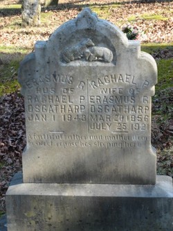
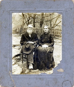
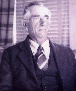
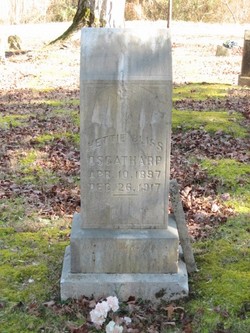
Rachael Prescovia Plumlee Osgatharp
| Birth | : | 20 Mar 1856 Jackson County, Tennessee, USA |
| Death | : | 25 Jul 1921 Clay County, Tennessee, USA |
| Burial | : | Salem Lutheran Cemetery, Woodville Township, Platte County, USA |
| Coordinate | : | 41.6525800, -97.8084000 |
| Description | : | Full name was Rachael Prescovia Plumlee Osgatharp, daughter of George Henshaw Plumlee and Marian "Polly" Kirk. She and each of her daughters died from tuberculosis. She is buried next to her husband, Erasmus Osgatharp. |
frequently asked questions (FAQ):
-
Where is Rachael Prescovia Plumlee Osgatharp's memorial?
Rachael Prescovia Plumlee Osgatharp's memorial is located at: Salem Lutheran Cemetery, Woodville Township, Platte County, USA.
-
When did Rachael Prescovia Plumlee Osgatharp death?
Rachael Prescovia Plumlee Osgatharp death on 25 Jul 1921 in Clay County, Tennessee, USA
-
Where are the coordinates of the Rachael Prescovia Plumlee Osgatharp's memorial?
Latitude: 41.6525800
Longitude: -97.8084000
Family Members:
Parent
Spouse
Siblings
Children
Flowers:


Nearby Cemetories:
1. Salem Lutheran Cemetery
Woodville Township, Platte County, USA
Coordinate: 41.6525800, -97.8084000
2. Looking Glass Cemetery
Rosenborg, Platte County, USA
Coordinate: 41.6571000, -97.7617000
3. Saint Ansgar Cemetery
Rosenborg, Platte County, USA
Coordinate: 41.6334000, -97.7539000
4. Bethany Lutheran Cemetery
Platte County, USA
Coordinate: 41.6232700, -97.7177200
5. Saint Edward Catholic Cemetery
Saint Edward, Boone County, USA
Coordinate: 41.5684800, -97.8424800
6. Evergreen Cemetery
Saint Edward, Boone County, USA
Coordinate: 41.5677986, -97.8411026
7. Hope Cemetery
Platte County, USA
Coordinate: 41.7383003, -97.7742004
8. Palestine Cemetery
Rosenborg, Platte County, USA
Coordinate: 41.5980000, -97.7057000
9. Boone Cemetery
Boone County, USA
Coordinate: 41.6272011, -97.9332962
10. Holy Family Cemetery
Lindsay, Platte County, USA
Coordinate: 41.6921997, -97.6832962
11. Trinity Cemetery
Newman Grove, Madison County, USA
Coordinate: 41.7574997, -97.8035965
12. West Hill Cemetery
Platte County, USA
Coordinate: 41.5558014, -97.7161026
13. Shell Creek Lutheran Cemetery
Newman Grove, Madison County, USA
Coordinate: 41.7717018, -97.7652969
14. Saint Paul Evangelical Lutheran Cemetery
Monroe, Platte County, USA
Coordinate: 41.5651140, -97.6740360
15. Saint Michael's Cemetery
Albion, Boone County, USA
Coordinate: 41.6991997, -97.9764023
16. Saint Johns Catholic Cemetery
Lindsay, Platte County, USA
Coordinate: 41.6293500, -97.6282500
17. Lingle Cemetery
Genoa, Nance County, USA
Coordinate: 41.5108000, -97.8384000
18. Rose Hill Cemetery
Albion, Boone County, USA
Coordinate: 41.6762000, -98.0003900
19. Evangelical Cemetery
Madison County, USA
Coordinate: 41.7625008, -97.6772003
20. Saint Bernard Cemetery
Lindsay, Platte County, USA
Coordinate: 41.7155991, -97.6286011
21. Postville Cemetery
Platte County, USA
Coordinate: 41.5924644, -97.6203079
22. Skeedee Cemetery
Nance County, USA
Coordinate: 41.5038986, -97.8850021
23. New Hope Cemetery
Monroe, Platte County, USA
Coordinate: 41.5413000, -97.6520000
24. Saint Pauls Lutheran Cemetery
Platte County, USA
Coordinate: 41.7425003, -97.6286011