Rachel Conner Matlick
| Birth | : | 3 Oct 1818 Preston County, West Virginia, USA |
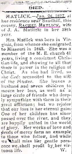
| Death | : | 24 Jan 1877 Sand Hill, Scotland County, Missouri, USA |
| Burial | : | Pine View Baptist Church Cemetery, Blythewood, Richland County, USA |
| Coordinate | : | 34.2370290, -80.9702230 |
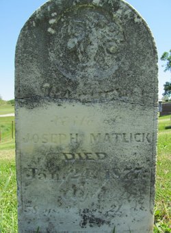
| Inscription | : | RACHEL Wife of JOSEPH MATLICK Died Jan. 24, 1877 Aged 58 ys, 3 ms, 21 ds |
| Description | : | Rachel was born in Preston County, West Virginia, the daughter of John and Martha A. (Glover) Conner. She married Joseph Matlick in 1834 in Preston County. They settled in Scotland County, Missouri in 1843. Joseph and Rachel had the following children: Josiah C., Elizabeth Jane, Martha Maria, Sarah A., Frances D., William R., John T., Mary D., Alice A., Joseph Talbert, Rachel Olinda, Amos Filmore, Taylor C., and a daughter that died in infancy. Cenotaph here |
frequently asked questions (FAQ):
-
Where is Rachel Conner Matlick's memorial?
Rachel Conner Matlick's memorial is located at: Pine View Baptist Church Cemetery, Blythewood, Richland County, USA.
-
When did Rachel Conner Matlick death?
Rachel Conner Matlick death on 24 Jan 1877 in Sand Hill, Scotland County, Missouri, USA
-
Where are the coordinates of the Rachel Conner Matlick's memorial?
Latitude: 34.2370290
Longitude: -80.9702230
Family Members:
Parent
Spouse
Siblings
Children
Flowers:
Nearby Cemetories:
1. Pine View Baptist Church Cemetery
Blythewood, Richland County, USA
Coordinate: 34.2370290, -80.9702230
2. Neeley Cemetery
Blythewood, Richland County, USA
Coordinate: 34.2453370, -80.9781110
3. Wright Family Cemetery
Richland County, USA
Coordinate: 34.2414100, -80.9523500
4. Bethel Baptist Church Cemetery
Blythewood, Richland County, USA
Coordinate: 34.2162740, -80.9781220
5. Saint Marks Lutheran Church Cemetery
Blythewood, Richland County, USA
Coordinate: 34.2119680, -80.9768454
6. Sandy Level Baptist Church Cemetery
Blythewood, Richland County, USA
Coordinate: 34.2139310, -80.9887430
7. Trinity United Methodist Church
Blythewood, Richland County, USA
Coordinate: 34.2143750, -80.9896770
8. Sandfield Cemetery
Richland County, USA
Coordinate: 34.2209900, -80.9391500
9. Raines Family Cemetery
Blythewood, Richland County, USA
Coordinate: 34.1993440, -80.9682550
10. Shepherd Cemetery
Blythewood, Richland County, USA
Coordinate: 34.1993400, -80.9682500
11. Mount Seir Baptist Church Cemetery
Blythewood, Richland County, USA
Coordinate: 34.1992820, -80.9663630
12. Hood Family Burial Site
Blythewood, Richland County, USA
Coordinate: 34.2100320, -80.9369330
13. Watts-Wilson Cemetery
Blythewood, Richland County, USA
Coordinate: 34.2304800, -80.9221000
14. Harmon-Kennedy-Rosborough Cemetery
Fairfield County, USA
Coordinate: 34.2752870, -80.9911570
15. Brown Family Cemetery
Blythewood, Richland County, USA
Coordinate: 34.2129910, -80.9256360
16. David H Montgomery Family Cemetery
Blythewood, Richland County, USA
Coordinate: 34.2141670, -80.9191670
17. Round Top Baptist Church Cemetery
Blythewood, Richland County, USA
Coordinate: 34.1993620, -80.9314080
18. Craig-Kennedy Family Cemetery
Fairfield County, USA
Coordinate: 34.2850000, -80.9950000
19. Johnson-Joyner Cemetery
Blythewood, Richland County, USA
Coordinate: 34.2557036, -80.9088908
20. Crankfield-Lawhorn Cemetery
Richland County, USA
Coordinate: 34.2310680, -80.9040460
21. Blanks Family Farm Cemetery
Blythewood, Richland County, USA
Coordinate: 34.2256050, -81.0372420
22. Saint Marks Lutheran Church Cemetery Annex
Blythewood, Richland County, USA
Coordinate: 34.1958000, -81.0194000
23. Mount Zion Baptist Church Cemetery
Blythewood, Richland County, USA
Coordinate: 34.1905400, -81.0236850
24. Broom Family Cemetery
Blythewood, Richland County, USA
Coordinate: 34.2227780, -81.0469440

