
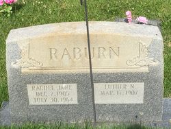
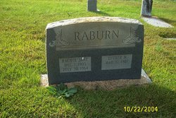
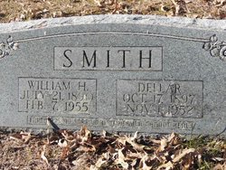
Rachel Jane Smith Raburn
| Birth | : | 7 Dec 1905 Alabama, USA |
| Death | : | 30 Jul 1964 Hackleburg, Marion County, Alabama, USA |
| Burial | : | Brown Cemetery, Donegal Township, Westmoreland County, USA |
| Coordinate | : | 40.1016998, -79.4064026 |
| Description | : | Rachell Jane Smith married Luther N. Raburn at the Brides home on 10 day of July 1927. By: Rev. L. M. Taylor. ∼Name: Rachel Raburn [Rachel Smith] Birth Date: abt 1906 Death Date: 30 Jul 1964 Death Place: Hackleburg, Marion, Alabama Death Age: 58 Marital Status: Married Gender: Female Father Name: George Smith Mother Name: Margaret Smith Spouse Name: Luther Raburn FHL Film Number: 1909069 Name: Rachel Jane Raburn Birth Date: 7 Dec 1905 Death Date: 30 Jul 1964 Cemetery: Union Hill Cemetery Burial or Cremation... Read More |
frequently asked questions (FAQ):
-
Where is Rachel Jane Smith Raburn's memorial?
Rachel Jane Smith Raburn's memorial is located at: Brown Cemetery, Donegal Township, Westmoreland County, USA.
-
When did Rachel Jane Smith Raburn death?
Rachel Jane Smith Raburn death on 30 Jul 1964 in Hackleburg, Marion County, Alabama, USA
-
Where are the coordinates of the Rachel Jane Smith Raburn's memorial?
Latitude: 40.1016998
Longitude: -79.4064026
Family Members:
Parent
Spouse
Siblings

Children
Flowers:


Nearby Cemetories:
1. Brown Cemetery
Donegal Township, Westmoreland County, USA
Coordinate: 40.1016998, -79.4064026
2. Keslar Cemetery
Fayette County, USA
Coordinate: 40.0995100, -79.4145100
3. Donegal Cemetery
Donegal, Westmoreland County, USA
Coordinate: 40.1112000, -79.3785000
4. Hays Cemetery
Mount Pleasant, Westmoreland County, USA
Coordinate: 40.1259000, -79.4021000
5. Walnut Hill Cemetery
Donegal, Westmoreland County, USA
Coordinate: 40.1040000, -79.3659000
6. Eutsey Cemetery Old
Fayette County, USA
Coordinate: 40.0781400, -79.4427900
7. Porch Cemetery
Donegal, Westmoreland County, USA
Coordinate: 40.1306000, -79.3711014
8. Byerly Freeman Cemetery
Mount Pleasant, Westmoreland County, USA
Coordinate: 40.1432500, -79.4100900
9. Eutsey Cemetery
Fayette County, USA
Coordinate: 40.0742400, -79.4474900
10. Melcroft Cemetery
Fayette County, USA
Coordinate: 40.0561000, -79.3829000
11. Knopsnider Cemetery New
Bullskin Township, Fayette County, USA
Coordinate: 40.0685400, -79.4686800
12. Knopsnider Cemetery (Old)
Bullskin Township, Fayette County, USA
Coordinate: 40.0691400, -79.4704800
13. Stouffer Cemetery
Bullskin Township, Fayette County, USA
Coordinate: 40.0848990, -79.4816900
14. Saint Raymonds Cemetery
Melcroft, Fayette County, USA
Coordinate: 40.0572014, -79.3531036
15. Mount Nebo Cemetery
Indian Head, Fayette County, USA
Coordinate: 40.0531000, -79.3556000
16. Dan Snyder Cemetery
Fayette County, USA
Coordinate: 40.0408000, -79.4317000
17. Mellinger Cemetery
Mellingertown, Westmoreland County, USA
Coordinate: 40.1432050, -79.4784730
18. Nicholson Cemetery
Clinton, Fayette County, USA
Coordinate: 40.0506100, -79.4745600
19. Good Hope Lutheran Cemetery
Fayette County, USA
Coordinate: 40.0282000, -79.3893900
20. Lobingier Cemetery
Mount Pleasant Township, Westmoreland County, USA
Coordinate: 40.1439030, -79.4887870
21. Franklin Lutheran Cemetery
Kregar, Westmoreland County, USA
Coordinate: 40.1215000, -79.3085000
22. Sparks Cemetery
Indian Head, Fayette County, USA
Coordinate: 40.0239200, -79.3892500
23. Brothers Cemetery
Fayette County, USA
Coordinate: 40.1360700, -79.5004300
24. Fairview Cemetery
Kecksburg, Westmoreland County, USA
Coordinate: 40.1696000, -79.4634000