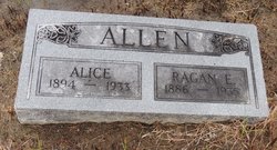
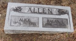
Ragan Ellsworth “Bob” Allen
| Birth | : | 24 Nov 1886 Goshen, Mercer County, Missouri, USA |
| Death | : | 10 May 1935 Parsons, Labette County, Kansas, USA |
| Burial | : | Lakeside Cemetery, Holly, Oakland County, USA |
| Coordinate | : | 42.7989006, -83.6164017 |
| Plot | : | Section 130 Block 08 Lot 017 Space 06 |
| Description | : | Ragan Elsworth “Bob” Allen, born November 24, 1886 in Goshen, Mercer, Missouri, USA and died May 10, 1935 in Parsons, Labette, Kansas. Parsons Sun, May 11, 1935 The funeral of Ragen Ellsworth Allen, 48, an MKT switchman who died suddenly Friday afternoon will be held at the Martin Funeral Home Monday afternoon at 3:30 conducted by the Rev. Riley Archer and interment in the family lot at Chanute. The funeral party driving overland at the conclusion of the services. Mr. Allen is survived by 2 daughters, Mrs. Edmond Stapleford, Madison Kansas, and Miss Evely of the home address, one son, Paul, 9 of... Read More |
frequently asked questions (FAQ):
-
Where is Ragan Ellsworth “Bob” Allen's memorial?
Ragan Ellsworth “Bob” Allen's memorial is located at: Lakeside Cemetery, Holly, Oakland County, USA.
-
When did Ragan Ellsworth “Bob” Allen death?
Ragan Ellsworth “Bob” Allen death on 10 May 1935 in Parsons, Labette County, Kansas, USA
-
Where are the coordinates of the Ragan Ellsworth “Bob” Allen's memorial?
Latitude: 42.7989006
Longitude: -83.6164017
Family Members:
Spouse
Children
Flowers:
Nearby Cemetories:
1. Lakeside Cemetery
Holly, Oakland County, USA
Coordinate: 42.7989006, -83.6164017
2. Oak Hill Cemetery
Holly, Oakland County, USA
Coordinate: 42.8067017, -83.6433029
3. Brookins Cemetery
Rose Township, Oakland County, USA
Coordinate: 42.7763062, -83.6528549
4. Olive Branch Cemetery
Holly, Oakland County, USA
Coordinate: 42.7907982, -83.5646973
5. Hadley Cemetery
Groveland Township, Oakland County, USA
Coordinate: 42.8302994, -83.5627975
6. Mitchell Family Cemetery
Holly, Oakland County, USA
Coordinate: 42.8492400, -83.6417500
7. Great Lakes National Cemetery
Holly, Oakland County, USA
Coordinate: 42.8597832, -83.6220322
8. Beebe Cemetery
Rose Township, Oakland County, USA
Coordinate: 42.7383003, -83.6468964
9. Saint Judes Episcopal Church Memorial Gardens
Fenton, Genesee County, USA
Coordinate: 42.7923440, -83.7050300
10. Saint John Catholic Cemetery
Fenton, Genesee County, USA
Coordinate: 42.8022530, -83.7100270
11. Bigelow Cemetery
Springfield, Oakland County, USA
Coordinate: 42.7797012, -83.5235977
12. Oakwood Cemetery
Fenton, Genesee County, USA
Coordinate: 42.7891998, -83.7133026
13. Rose Center Cemetery
Rose Township, Oakland County, USA
Coordinate: 42.7268982, -83.6102982
14. Davisburg Cemetery
Davisburg, Oakland County, USA
Coordinate: 42.7543983, -83.5306015
15. Gage Cemetery
Fenton Township, Genesee County, USA
Coordinate: 42.8570900, -83.6961900
16. South Grand Blanc Cemetery
Grand Blanc, Genesee County, USA
Coordinate: 42.8842010, -83.6410980
17. Smith Burial Site
Fenton, Genesee County, USA
Coordinate: 42.8631460, -83.7016000
18. Mount Bethel Cemetery
Ortonville, Oakland County, USA
Coordinate: 42.8027610, -83.4926610
19. Long Branch Cemetery
Fenton, Genesee County, USA
Coordinate: 42.8588700, -83.7230320
20. Horton Cemetery
Goodrich, Genesee County, USA
Coordinate: 42.8849983, -83.5330963
21. Rawda Cemetery
Fenton, Genesee County, USA
Coordinate: 42.7148868, -83.7046601
22. Tyrone Memory Gardens
Tyrone Township, Livingston County, USA
Coordinate: 42.7699630, -83.7560750
23. Colwell Cemetery
Tyrone Township, Livingston County, USA
Coordinate: 42.7708060, -83.7604740
24. Oakwood Cemetery
Grand Blanc, Genesee County, USA
Coordinate: 42.9122009, -83.6022034


