

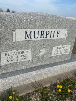
Ralph Dale Murphy
| Birth | : | 24 Feb 1914 Downs, Osborne County, Kansas, USA |
| Death | : | 23 Mar 2003 Plainville, Rooks County, Kansas, USA |
| Burial | : | Natoma Cemetery, Natoma, Osborne County, USA |
| Coordinate | : | 39.1907700, -99.0162700 |
| Description | : | Ralph D. Murphy, 89, died Sunday, March 23, 2003, at Rooks County Hospital, Plainville. He was born Feb. 24, 1914, on the family farm near Downs to Austin and Flossie (Earls) Murphy. He moved to Natoma and attended local schools. He married Eleanor J. Winder on Jan. 22, 1943, in Russell. He was a longtime Natoma area resident and area farmer and stockman. Survivors include his wife, of the home; three sons, Lonnie and Mark, both of Hays, and Ronnie, Natoma; a daughter, Connie McNeal, Paradise; two sisters, Ruth Winder, Osborne, and Hazel Winder, Waldo; 12 grandchildren;... Read More |
frequently asked questions (FAQ):
-
Where is Ralph Dale Murphy's memorial?
Ralph Dale Murphy's memorial is located at: Natoma Cemetery, Natoma, Osborne County, USA.
-
When did Ralph Dale Murphy death?
Ralph Dale Murphy death on 23 Mar 2003 in Plainville, Rooks County, Kansas, USA
-
Where are the coordinates of the Ralph Dale Murphy's memorial?
Latitude: 39.1907700
Longitude: -99.0162700
Family Members:
Parent
Spouse
Siblings
Flowers:


Nearby Cemetories:
1. Natoma Cemetery
Natoma, Osborne County, USA
Coordinate: 39.1907700, -99.0162700
2. Natoma Lutheran Cemetery
Natoma, Osborne County, USA
Coordinate: 39.1907700, -99.0162700
3. Natoma Catholic Cemetery
Natoma, Osborne County, USA
Coordinate: 39.2054050, -99.0289480
4. Immanuel Lutheran Cemetery
Natoma, Osborne County, USA
Coordinate: 39.2708015, -99.0096970
5. Mount Hermon Cemetery
Paradise, Russell County, USA
Coordinate: 39.1324997, -98.9439011
6. Bowlby Ranch Cemetery
Ellis County, USA
Coordinate: 39.1127430, -99.0513540
7. Round Mound Cemetery
Osborne County, USA
Coordinate: 39.2630997, -98.9636002
8. Conger Cemetery
Plainville, Rooks County, USA
Coordinate: 39.1978700, -99.1232100
9. IXL Cemetery
Natoma, Osborne County, USA
Coordinate: 39.2491989, -98.9218979
10. Aurora Cemetery
Laton, Rooks County, USA
Coordinate: 39.2778015, -99.0847015
11. Shiloh Cemetery
Codell, Rooks County, USA
Coordinate: 39.2350006, -99.1410980
12. Victor Cemetery
Osborne County, USA
Coordinate: 39.2380981, -98.8613968
13. Norman Cemetery
Ellis County, USA
Coordinate: 39.1044006, -99.1575012
14. Chalk Mound Cemetery
Laton, Rooks County, USA
Coordinate: 39.3208008, -99.0852966
15. Fairport Cemetery
Russell County, USA
Coordinate: 39.0463982, -99.0207977
16. Cedar Bluff Cemetery
Osborne County, USA
Coordinate: 39.2496986, -98.8431015
17. Pleasant Plain Cemetery
Osborne County, USA
Coordinate: 39.3367004, -99.0372009
18. Paradise Center Cemetery
Codell, Rooks County, USA
Coordinate: 39.2050570, -99.2058100
19. Cole Cemetery
Osborne County, USA
Coordinate: 39.2352982, -98.8060989
20. Waldo Catholic Cemetery
Waldo Township, Russell County, USA
Coordinate: 39.1036600, -98.8162400
21. Covert Cemetery
Osborne County, USA
Coordinate: 39.2896996, -98.8107986
22. Mount Ayr Cemetery
Alton, Osborne County, USA
Coordinate: 39.3764000, -98.9717026
23. Twin Mound Cemetery
Rooks County, USA
Coordinate: 39.2855988, -99.2319031
24. Survey Cemetery
Woodston, Rooks County, USA
Coordinate: 39.3722000, -99.1333008