
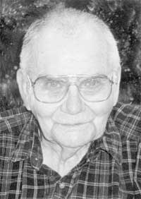

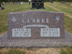
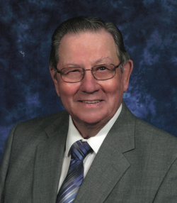
Ralph Harold Emil Clarke
| Birth | : | 15 Jan 1918 Wessington, Beadle County, South Dakota, USA |
| Death | : | 10 Dec 2007 Miller, Hand County, South Dakota, USA |
| Burial | : | Gympie Cemetery, Gympie, Gympie Region, Australia |
| Coordinate | : | -26.1749860, 152.6530570 |
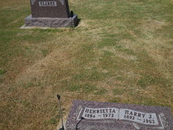
| Description | : | Ralph Clarke, age 89, of Miller, SD, and formerly of Wessington, died Monday, December 10, 2007, at the Prairie Good Samaritan Center at Miller, SD. Ralph Harold Emil Clarke was born on January 15, 1918, to Harry and Henrietta "Etta" (Martens) Clarke at his grandparent's farm house in Nance Township, Beadle County, near Wessington, SD. He moved with his parents to a farm in Hand County when he was one year old. He attended Brown School through the eighth grade and two years of high school in Wessington. He left school as he was needed to help on the family... Read More |
frequently asked questions (FAQ):
-
Where is Ralph Harold Emil Clarke's memorial?
Ralph Harold Emil Clarke's memorial is located at: Gympie Cemetery, Gympie, Gympie Region, Australia.
-
When did Ralph Harold Emil Clarke death?
Ralph Harold Emil Clarke death on 10 Dec 2007 in Miller, Hand County, South Dakota, USA
-
Where are the coordinates of the Ralph Harold Emil Clarke's memorial?
Latitude: -26.1749860
Longitude: 152.6530570
Family Members:
Parent

Spouse

Siblings
Children
Flowers:


Nearby Cemetories:
1. Gympie Cemetery
Gympie, Gympie Region, Australia
Coordinate: -26.1749860, 152.6530570
2. Cooloola Coast Crematorium
Monkland, Gympie Region, Australia
Coordinate: -26.2148230, 152.6868250
3. Tozer Park Cemetery (Defunct)
Gympie, Gympie Region, Australia
Coordinate: -26.0008330, 152.7438890
4. Neerdie Cemetery
Gympie, Gympie Region, Australia
Coordinate: -26.0008540, 152.7442570
5. Gunalda Cemetery
Gunalda, Gympie Region, Australia
Coordinate: -25.9877920, 152.5557680
6. Kandanga Cemetery
Kandanga, Gympie Region, Australia
Coordinate: -26.3842440, 152.6888120
7. Pomona Cemetery
Pomona, Noosa Shire, Australia
Coordinate: -26.3441600, 152.8530740
8. Dickabram Cemetery
Miva, Gympie Region, Australia
Coordinate: -25.9604510, 152.4848260
9. Munna Creek Cemetery
Gundiah, Fraser Coast Region, Australia
Coordinate: -25.8943010, 152.4806150
10. Cooroy Cemetery
Cooroy, Noosa Shire, Australia
Coordinate: -26.4095520, 152.9143240
11. Cooloola Coast Cemetery
Cooloola Cove, Gympie Region, Australia
Coordinate: -25.9831920, 152.9677170
12. Kilkivan Cemetery
Kilkivan, Gympie Region, Australia
Coordinate: -26.1072030, 152.2758930
13. Gheerulla Cemetery
Gheerulla, Sunshine Coast Council, Australia
Coordinate: -26.5538100, 152.7713320
14. Tewantin Cemetery
Tewantin, Noosa Shire, Australia
Coordinate: -26.3950054, 153.0254472
15. Eumundi Cemetery
Eumundi, Sunshine Coast Council, Australia
Coordinate: -26.4913680, 152.9405570
16. Deborah Cemetery
Netherby, Fraser Coast Region, Australia
Coordinate: -25.7827119, 152.4940048
17. Tiaro Cemetery
Tiaro, Fraser Coast Region, Australia
Coordinate: -25.7173650, 152.5856850
18. Yandina Cemetery
Yandina, Sunshine Coast Council, Australia
Coordinate: -26.5720000, 152.9570000
19. Mapleton Cemetery
Mapleton, Sunshine Coast Council, Australia
Coordinate: -26.6241030, 152.8479884
20. Kulangoor Lawn Cemetery
Kulangoor, Sunshine Coast Council, Australia
Coordinate: -26.5884880, 152.9647280
21. Nambour Garden Lawn Cemetery
Nambour, Sunshine Coast Council, Australia
Coordinate: -26.6116920, 152.9700810
22. Gregson & Weight Chapel & Crematorium
Nambour, Sunshine Coast Council, Australia
Coordinate: -26.6156420, 152.9649380
23. Nambour General Cemetery
Nambour, Sunshine Coast Council, Australia
Coordinate: -26.6156180, 152.9713150
24. Goomeri Cemetery
Goomeri, Gympie Region, Australia
Coordinate: -26.1825340, 152.0681620