
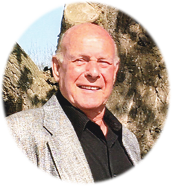
Ralph Holm
| Birth | : | 3 Jun 1938 Bon Homme County, South Dakota, USA |
| Death | : | 19 Feb 2021 Dell Rapids, Minnehaha County, South Dakota, USA |
| Burial | : | Emery Community Cemetery, Emery, Hanson County, USA |
| Coordinate | : | 43.5572014, -97.6474991 |
| Plot | : | Block 4 Lot 14 |
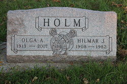
| Description | : | Ralph Holm, 82, of Dell Rapids, SD formerly of Selma, CA, passed away unexpectedly Friday, February 19, 2021 at Avera Dells Hospital in Dell Rapids. A funeral service will be 10:30 AM Friday, February 26, 2021 at First Baptist Church in Emery, SD. Burial will be at Emery Community Cemetery. Visitation will be one hour prior to the funeral service at the Church. The family requests masks are worn at the funeral services. Arrangements by Bittner Funeral Chapel. Ralph Donald Holm was born on June 3, 1938 to Hilmer and Olga Holm on the family farm near Scotland, SD.... Read More |
frequently asked questions (FAQ):
-
Where is Ralph Holm's memorial?
Ralph Holm's memorial is located at: Emery Community Cemetery, Emery, Hanson County, USA.
-
When did Ralph Holm death?
Ralph Holm death on 19 Feb 2021 in Dell Rapids, Minnehaha County, South Dakota, USA
-
Where are the coordinates of the Ralph Holm's memorial?
Latitude: 43.5572014
Longitude: -97.6474991
Family Members:
Parent

Spouse

Children
Flowers:


Nearby Cemetories:
1. Emery Community Cemetery
Emery, Hanson County, USA
Coordinate: 43.5572014, -97.6474991
2. Elfert Cemetery
Hanson County, USA
Coordinate: 43.5727997, -97.6868973
3. New Hope Cemetery
Hanson County, USA
Coordinate: 43.5102997, -97.6457977
4. Saint Martins Lutheran Cemetery
Hanson County, USA
Coordinate: 43.5729560, -97.7171440
5. Saint Martins Catholic Cemetery
Emery, Hanson County, USA
Coordinate: 43.6147003, -97.6271973
6. Plum Creek Baptist Cemetery
Emery, Hanson County, USA
Coordinate: 43.4905900, -97.6794100
7. Rasmussen Cemetery
Bridgewater, McCook County, USA
Coordinate: 43.5283012, -97.5567017
8. Saint Peters Lutheran Cemetery
Clayton, Hutchinson County, USA
Coordinate: 43.4721985, -97.6557999
9. Suelzle Seventh-day Adventist Cemetery
Milltown, Hutchinson County, USA
Coordinate: 43.4869194, -97.7195358
10. Bridgewater Cemetery
Bridgewater, McCook County, USA
Coordinate: 43.5541600, -97.5059400
11. Schrag Farm Cemetery
Bridgewater, McCook County, USA
Coordinate: 43.4760720, -97.5570940
12. Hofer Cemetery
Freeman, Hutchinson County, USA
Coordinate: 43.4726830, -97.5299150
13. Rademacher Cemetery
Hutchinson County, USA
Coordinate: 43.4361000, -97.6580963
14. Neu Hutterthal Mennonite Cemetery
Hutchinson County, USA
Coordinate: 43.4510040, -97.5605320
15. Saint Stephens Cemetery
Bridgewater, McCook County, USA
Coordinate: 43.5574989, -97.4766998
16. Old Elmspring Hutterite Cemetery
Alexandria, Hanson County, USA
Coordinate: 43.4984894, -97.7991001
17. Salem Mennonite Brethren Church Cemetery
Hutchinson County, USA
Coordinate: 43.4440240, -97.5660950
18. Green Hill Cemetery
Alexandria, Hanson County, USA
Coordinate: 43.6582985, -97.7641983
19. Saint Marys Cemetery
Alexandria, Hanson County, USA
Coordinate: 43.6486015, -97.7855988
20. Wolf Creek Congregational Cemetery
Freeman, Hutchinson County, USA
Coordinate: 43.4150150, -97.6385980
21. Unity Lutheran Cemetery
Freeman, Hutchinson County, USA
Coordinate: 43.4151550, -97.6198680
22. Pleasant Prairie Cemetery
Bridgewater, McCook County, USA
Coordinate: 43.5430984, -97.4496994
23. Friedhof Rockport Colony Cemetery
Alexandria, Hanson County, USA
Coordinate: 43.5834400, -97.8451200
24. New Elmspring Hutterite Cemetery
Parkston, Hutchinson County, USA
Coordinate: 43.4899411, -97.8312111