
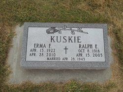
Ralph Kurkowski Kuskie
| Birth | : | 8 Oct 1916 Perkins County, Nebraska, USA |
| Death | : | 15 Apr 2005 Grant, Perkins County, Nebraska, USA |
| Burial | : | Crab Creek Baptist Church Cemetery, Henderson County, USA |
| Coordinate | : | 35.2454987, -82.5476990 |
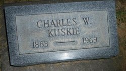
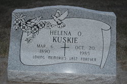
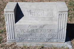
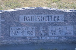
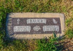
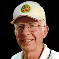
| Description | : | Ralph Kuskie Ralph Kuskie was born on Oct. 8, 1916 northwest of Grant, Neb. He was the fourth of eight children born to Charles and Helena Kurkowski Kuskie. He attended rural school through the eighth grade at District No. 43. After his schooling, Ralph began his lifelong career of farming. Ralph was married to Erma Bauer on April 28, 1943 in Grant. They made their first home 12 miles west of Grant and in 1945 they moved to their present farm location three miles west of Grant. In addition to his farming and milking cows, Ralph worked for a brief... Read More |
frequently asked questions (FAQ):
-
Where is Ralph Kurkowski Kuskie's memorial?
Ralph Kurkowski Kuskie's memorial is located at: Crab Creek Baptist Church Cemetery, Henderson County, USA.
-
When did Ralph Kurkowski Kuskie death?
Ralph Kurkowski Kuskie death on 15 Apr 2005 in Grant, Perkins County, Nebraska, USA
-
Where are the coordinates of the Ralph Kurkowski Kuskie's memorial?
Latitude: 35.2454987
Longitude: -82.5476990
Family Members:
Parent
Spouse

Siblings
Children
Flowers:


Nearby Cemetories:
1. Crab Creek Baptist Church Cemetery
Henderson County, USA
Coordinate: 35.2454987, -82.5476990
2. Crab Creek Church Cemetery
Henderson County, USA
Coordinate: 35.2536490, -82.5572710
3. Adriance Family Cemetery
Henderson County, USA
Coordinate: 35.2511700, -82.5238300
4. Harden Family Cemetery
Henderson County, USA
Coordinate: 35.2505100, -82.5191000
5. Saint Francis Chapel Memorial Garden
Henderson County, USA
Coordinate: 35.2641670, -82.5200440
6. Sentell Family Cemetery
Henderson County, USA
Coordinate: 35.2752991, -82.5468979
7. Brown Family Cemetery
Henderson County, USA
Coordinate: 35.2779600, -82.5336300
8. Follies Cemeteries
Etowah, Henderson County, USA
Coordinate: 35.2660600, -82.5817900
9. Hoxit Family Cemetery
Henderson County, USA
Coordinate: 35.2409400, -82.5958000
10. Holly Springs Baptist Church Cemetery
Henderson County, USA
Coordinate: 35.2406960, -82.5968940
11. Anderson Cemetery
Henderson County, USA
Coordinate: 35.2502000, -82.6002300
12. Pleasant Hill Cemetery
Valley Hill, Henderson County, USA
Coordinate: 35.2750015, -82.4993973
13. Sentell Cemetery
Henderson County, USA
Coordinate: 35.2593994, -82.6061020
14. Berea Baptist Church Cemetery
Flat Rock, Henderson County, USA
Coordinate: 35.2564011, -82.4875031
15. Cantrell Family Cemetery
Henderson County, USA
Coordinate: 35.2869119, -82.5096819
16. Mountain Valley Baptist Church Cemetery
Zirconia, Henderson County, USA
Coordinate: 35.2146988, -82.4938965
17. McDowell Cemetery
Zirconia, Henderson County, USA
Coordinate: 35.1971000, -82.5058000
18. Beulah Baptist Church Cemetery
Henderson County, USA
Coordinate: 35.3041992, -82.5580978
19. Mount Olivet Baptist Church Cemetery
Zirconia, Henderson County, USA
Coordinate: 35.2366900, -82.4749000
20. Pleasant Grove Cemetery
Etowah, Henderson County, USA
Coordinate: 35.2888985, -82.5999985
21. Thomas Cemetery
Transylvania County, USA
Coordinate: 35.2000008, -82.6007996
22. Thomas Fletcher Cemetery
Etowah, Henderson County, USA
Coordinate: 35.2969017, -82.5947037
23. McCall Cemetery
Transylvania County, USA
Coordinate: 35.2569008, -82.6268997
24. Little River Baptist Church Cemetery
Penrose, Transylvania County, USA
Coordinate: 35.2425308, -82.6288071