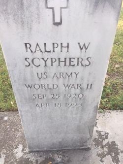
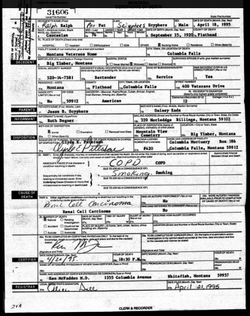
Ralph William “Pat” Scyphers
| Birth | : | 25 Sep 1920 Big Timber, Sweet Grass County, Montana, USA |
| Death | : | 18 Apr 1995 Columbia Falls, Flathead County, Montana, USA |
| Burial | : | Riverview Cemetery, Washburn, McLean County, USA |
| Coordinate | : | 47.2846985, -101.0113983 |
| Plot | : | Section 5 Block 23R Lot 1 Grave 9 |
| Description | : | Big Timber Pioneer, April 28, 1995 Ralph W. "Pat" Scyphers of Butte passed away April 18, 1995, in the Montana Veterans Home in Columbia Falls after a brief illness. He was born September 25, 1920, in Big Timber, the son of Jess and Daisy Scyphers. Pat was raised on a ranch on the Boulder River south of Big Timber where he attended school, later moving to Missoula. He met and married Alice Woods in 1939. Pat served in World War II with the 8th Air Force in North Africa, Tunesia, Rone, Anzio, and Southern France. His unit was awarded the... Read More |
frequently asked questions (FAQ):
-
Where is Ralph William “Pat” Scyphers's memorial?
Ralph William “Pat” Scyphers's memorial is located at: Riverview Cemetery, Washburn, McLean County, USA.
-
When did Ralph William “Pat” Scyphers death?
Ralph William “Pat” Scyphers death on 18 Apr 1995 in Columbia Falls, Flathead County, Montana, USA
-
Where are the coordinates of the Ralph William “Pat” Scyphers's memorial?
Latitude: 47.2846985
Longitude: -101.0113983
Family Members:
Spouse
Nearby Cemetories:
1. Riverview Cemetery
Washburn, McLean County, USA
Coordinate: 47.2846985, -101.0113983
2. Baptist Cemetery
Washburn, McLean County, USA
Coordinate: 47.3013500, -101.0243000
3. Zion Lutheran Cemetery
Washburn, McLean County, USA
Coordinate: 47.3015500, -101.0349000
4. Hensler Cemetery
Hensler, Oliver County, USA
Coordinate: 47.2708015, -101.0864029
5. Bagnell Cemetery
Oliver County, USA
Coordinate: 47.2224998, -101.0111008
6. Gaines Cemetery
Oliver County, USA
Coordinate: 47.2141991, -101.0108032
7. Sverdrup Cemetery
McLean County, USA
Coordinate: 47.3563995, -101.0028000
8. Wing Cemetery
McLean County, USA
Coordinate: 47.2291985, -100.9285965
9. Sanger Cemetery
Sanger, Oliver County, USA
Coordinate: 47.1852989, -101.0017014
10. Conkling Cemetery
McLean County, USA
Coordinate: 47.3125000, -101.1825027
11. Daub Hill Cemetery
Fort Clark, Oliver County, USA
Coordinate: 47.2365300, -101.1941760
12. Fairview Methodist Cemetery
Wilton, McLean County, USA
Coordinate: 47.2905952, -100.8125186
13. Bethal Baptist Cemetery
McLean County, USA
Coordinate: 47.4038700, -100.9071400
14. Zion Baptist Cemetery
McLean County, USA
Coordinate: 47.3518982, -100.7985992
15. Ingersoll Cemetery
Washburn, McLean County, USA
Coordinate: 47.4516000, -100.9915800
16. South Saint Olaf Cemetery
Turtle Lake, McLean County, USA
Coordinate: 47.4079933, -100.8432465
17. Birka Lutheran Cemetery
Falkirk, McLean County, USA
Coordinate: 47.3572300, -101.2478000
18. Saint Johns Cemetery
Underwood, McLean County, USA
Coordinate: 47.4364014, -101.1641998
19. Riverview Cemetery
Wilton, McLean County, USA
Coordinate: 47.1589012, -100.8007965
20. Saint Bonaventure Catholic Church Cemetery
Underwood, McLean County, USA
Coordinate: 47.4535800, -101.1422450
21. Sacred Heart Cemetery
Wilton, McLean County, USA
Coordinate: 47.1791992, -100.7705994
22. Holy Trinity Orthodox Cemetery
Wilton, McLean County, USA
Coordinate: 47.1780160, -100.7709360
23. Saints Peter and Paul Cemetery
Wilton, McLean County, USA
Coordinate: 47.1786003, -100.7703018
24. Zoar Cemetery
Underwood, McLean County, USA
Coordinate: 47.4157982, -101.2260971


