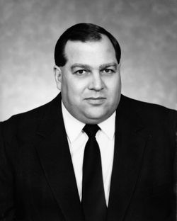
| Birth | : | 19 Aug 1950 |
| Death | : | 29 Aug 1998 |
| Burial | : | Shreve Cemetery, Shreve, Wayne County, USA |
| Coordinate | : | 40.6981010, -82.0056000 |
| Plot | : | Section 1 |
| Description | : | MISSOULA – Randall Aaron Haker, 48, a Great Falls native and electrician, drowned in a boating accident Saturday at Lake Mary Ronan. Services are noon Saturday at his cabin, 18 miles south of Stanford on the Dry Wolf Road in the Little Belt Mountains. Garden City Funeral Home of Missoula is in charge of arrangements. Memorials are suggested to the Randy Haker Athletic Memorial Fund c/o Hellgate High School, 900 South Higgins, Missoula, MT 59801. He was born Aug. 19, 1950, in Great Falls. He graduated from Stanford High School and attended Montana State University at Bozeman. |
frequently asked questions (FAQ):
-
Where is Randall Aaron Haker's memorial?
Randall Aaron Haker's memorial is located at: Shreve Cemetery, Shreve, Wayne County, USA.
-
When did Randall Aaron Haker death?
Randall Aaron Haker death on 29 Aug 1998 in
-
Where are the coordinates of the Randall Aaron Haker's memorial?
Latitude: 40.6981010
Longitude: -82.0056000
Family Members:
Parent
Siblings
Flowers:
Nearby Cemetories:
1. Shreve Cemetery
Shreve, Wayne County, USA
Coordinate: 40.6981010, -82.0056000
2. Bills Cemetery
Shreve, Wayne County, USA
Coordinate: 40.6797930, -82.0225600
3. Millbrook Cemetery
Millbrook, Wayne County, USA
Coordinate: 40.7234001, -82.0052032
4. Pioneer Cemetery
Clinton Township, Wayne County, USA
Coordinate: 40.6792500, -82.0368180
5. County Line Cemetery
Prairie Township, Holmes County, USA
Coordinate: 40.6671480, -81.9812940
6. Manley Cemetery
Shreve, Wayne County, USA
Coordinate: 40.6975331, -82.0534689
7. Butler Cemetery
Moreland, Wayne County, USA
Coordinate: 40.6796670, -81.9557780
8. Moreland Cemetery
Moreland, Wayne County, USA
Coordinate: 40.7120018, -81.9434967
9. Maple Grove Cemetery
Blachleyville, Wayne County, USA
Coordinate: 40.7464447, -82.0487595
10. Branch Cemetery
Wooster, Wayne County, USA
Coordinate: 40.7550011, -81.9828033
11. Ripley Cemetery
Big Prairie, Holmes County, USA
Coordinate: 40.6517258, -82.0623703
12. Ripley Township Cemetery
Big Prairie, Holmes County, USA
Coordinate: 40.6640710, -82.0766050
13. Moorhead Cemetery
Holmesville, Holmes County, USA
Coordinate: 40.6292620, -81.9960310
14. Miller Cemetery #1
Guerne, Wayne County, USA
Coordinate: 40.7153380, -81.9158380
15. Plain Lutheran Cemetery
Blachleyville, Wayne County, USA
Coordinate: 40.7672997, -82.0241013
16. Andy M Yoder Farm Cemetery
Holmesville, Holmes County, USA
Coordinate: 40.6277040, -81.9891520
17. Peniel Christian Fellowship Cemetery
Holmesville, Holmes County, USA
Coordinate: 40.6288967, -81.9762194
18. Bigelow Cemetery
Big Prairie, Holmes County, USA
Coordinate: 40.6324348, -82.0517654
19. Newkirk Cemetery
Shreve, Wayne County, USA
Coordinate: 40.6823006, -82.1017990
20. Rittenhouse Farm Cemetery
Blachleyville, Wayne County, USA
Coordinate: 40.7665810, -82.0475410
21. Franks Cemetery
Moreland, Wayne County, USA
Coordinate: 40.7107010, -81.9057007
22. Nonpariel Cemetery
Wayne County, USA
Coordinate: 40.7107346, -81.9056154
23. Bethany Mennonite Church Cemetery
Holmesville, Holmes County, USA
Coordinate: 40.6494580, -81.9238940
24. Gorrell Cemetery
Holmes County, USA
Coordinate: 40.6208000, -81.9841995


