
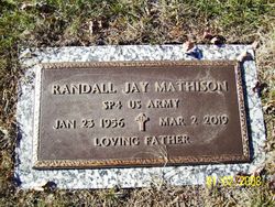
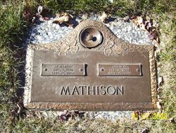
Randall Jay “Randy” Mathison
| Birth | : | 23 Jan 1956 Spencer, Clay County, Iowa, USA |
| Death | : | 2 Mar 2019 Bella Vista, Benton County, Arkansas, USA |
| Burial | : | North Lawn Cemetery, Spencer, Clay County, USA |
| Coordinate | : | 43.1600000, -95.1470000 |
| Inscription | : | SP4 US ARMY LOVING FATHER |
| Description | : | Randy was the second of three children born to Lillie and Marv Mathison. He was born in Spencer, Iowa and grew up in Laurens, Iowa. He learned his lifetime hobbies of hunting, fishing, trapping, and trap shooting, and motorcycling from his dad at a very young age. Randy was a dedicated worker with an engaged work ethic his entire life. He served in the US Army from 1974 to 1978. After the Army he worked building bridges in Kansas City and settled shortly thereafter in his loved Bella Vista, Arkansas. He obtained his HVAC certification and spent the... Read More |
frequently asked questions (FAQ):
-
Where is Randall Jay “Randy” Mathison's memorial?
Randall Jay “Randy” Mathison's memorial is located at: North Lawn Cemetery, Spencer, Clay County, USA.
-
When did Randall Jay “Randy” Mathison death?
Randall Jay “Randy” Mathison death on 2 Mar 2019 in Bella Vista, Benton County, Arkansas, USA
-
Where are the coordinates of the Randall Jay “Randy” Mathison's memorial?
Latitude: 43.1600000
Longitude: -95.1470000
Family Members:
Parent

Flowers:


Nearby Cemetories:
1. North Lawn Cemetery
Spencer, Clay County, USA
Coordinate: 43.1600000, -95.1470000
2. Dewey Readmore Books Memorial
Spencer, Clay County, USA
Coordinate: 43.1403999, -95.1443024
3. Riverside Cemetery
Spencer, Clay County, USA
Coordinate: 43.1441994, -95.1671982
4. Fairview Cemetery
Clay County, USA
Coordinate: 43.1899986, -95.0800018
5. Evergreen Cemetery
Clay County, USA
Coordinate: 43.2052994, -95.2086029
6. Dickens Cemetery
Dickens, Clay County, USA
Coordinate: 43.1280000, -95.0155000
7. Swedish Lutheran Cemetery
Royal, Clay County, USA
Coordinate: 43.0683000, -95.2350000
8. Little Sioux Lutheran Cemetery
Milford, Dickinson County, USA
Coordinate: 43.2702065, -95.2109528
9. Rosehill Cemetery
Clay County, USA
Coordinate: 43.0368996, -95.0919037
10. First Reformed Cemetery
Clay County, USA
Coordinate: 43.2399500, -95.2889000
11. Lone Tree Cemetery
Everly, Clay County, USA
Coordinate: 43.1411018, -95.3347015
12. Milford Cemetery
Milford, Dickinson County, USA
Coordinate: 43.3092003, -95.1481018
13. Lincoln Cemetery
Rossie, Clay County, USA
Coordinate: 43.0111008, -95.2313995
14. Calvary Cemetery
Milford, Dickinson County, USA
Coordinate: 43.3213997, -95.1688995
15. Logan Township Cemetery
Clay County, USA
Coordinate: 43.0489006, -94.9747009
16. Liberty Cemetery
Greenville, Clay County, USA
Coordinate: 42.9897003, -95.1417007
17. Willow Creek Cemetery
Royal, Clay County, USA
Coordinate: 43.0214005, -95.2885971
18. Clay Center Cemetery
Royal, Clay County, USA
Coordinate: 43.0410995, -95.3272018
19. TriMello Cemetery
Royal, Clay County, USA
Coordinate: 43.0682983, -95.3728027
20. Crown Hill Cemetery
Ruthven, Palo Alto County, USA
Coordinate: 43.1328011, -94.8878021
21. Calvary Cemetery
Ruthven, Palo Alto County, USA
Coordinate: 43.1314011, -94.8869019
22. Zion Methodist Cemetery
Clay County, USA
Coordinate: 42.9808006, -95.2497025
23. Westport Cemetery
Dickinson County, USA
Coordinate: 43.3130989, -95.3289032
24. Okoboji Cemetery
Arnolds Park, Dickinson County, USA
Coordinate: 43.3649406, -95.1303558