
| Birth | : | 25 May 1954 Moncks Corner, Berkeley County, South Carolina, USA |
| Death | : | 25 Aug 2018 Florence, Florence County, South Carolina, USA |
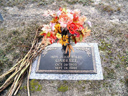
| Burial | : | Clarendon Memorial Gardens, Manning, Clarendon County, USA |
| Coordinate | : | 33.6863922, -80.1952051 |
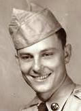
| Description | : | Randolph Lee “Randy” Garrett, Jr., 64, widower of Barbara Brock Garrett, died Saturday, August 25, 2018, at McLeod Regional Medical Center. Born May 25, 1954, in Moncks Corner, he was a son of the late Randolph Lee Garrett, Sr. and the late Ada Jean Wiles Garrett. He was a former Chief of Police for the City of Manning and the former Sheriff of Clarendon County. |
frequently asked questions (FAQ):
-
Where is Randolph Lee “Randy” Garrett Jr.'s memorial?
Randolph Lee “Randy” Garrett Jr.'s memorial is located at: Clarendon Memorial Gardens, Manning, Clarendon County, USA.
-
When did Randolph Lee “Randy” Garrett Jr. death?
Randolph Lee “Randy” Garrett Jr. death on 25 Aug 2018 in Florence, Florence County, South Carolina, USA
-
Where are the coordinates of the Randolph Lee “Randy” Garrett Jr.'s memorial?
Latitude: 33.6863922
Longitude: -80.1952051
Family Members:
Parent
Spouse

Siblings

Flowers:


Nearby Cemetories:
1. Clarendon Memorial Gardens
Manning, Clarendon County, USA
Coordinate: 33.6863922, -80.1952051
2. Price-Snyder Cemetery
Manning, Clarendon County, USA
Coordinate: 33.6863670, -80.1948270
3. Manning Cemetery
Manning, Clarendon County, USA
Coordinate: 33.7024994, -80.2061005
4. Oak Grove Methodist Cemetery
Manning, Clarendon County, USA
Coordinate: 33.6660230, -80.1916550
5. Holladay Family Cemetery
Manning, Clarendon County, USA
Coordinate: 33.6763030, -80.2255100
6. Fellowship Missionary Baptist Church Cemetery
Manning, Clarendon County, USA
Coordinate: 33.6906160, -80.2297120
7. Blackwell Grave Site
Manning, Clarendon County, USA
Coordinate: 33.6566730, -80.1888140
8. Scarborough Cemetery
Clarendon County, USA
Coordinate: 33.6591610, -80.1792220
9. Providence Christian Church Cemetery
Manning, Clarendon County, USA
Coordinate: 33.6709470, -80.1621820
10. Freewill Goodwill Baptist Church Cemetery
Manning, Clarendon County, USA
Coordinate: 33.6533690, -80.1947830
11. Saint Matthew Cemetery
Manning, Clarendon County, USA
Coordinate: 33.6809600, -80.1550610
12. Thompson-Juneburn Cemetery
Clarendon County, USA
Coordinate: 33.7124901, -80.1680984
13. Community Deliverance Temple
Alcolu, Clarendon County, USA
Coordinate: 33.7219530, -80.1942370
14. Fair Heaven Baptist Church
Manning, Clarendon County, USA
Coordinate: 33.7119810, -80.1643690
15. Providence AME Church Cemetery
Clarendon County, USA
Coordinate: 33.6628800, -80.1591340
16. Ridgill Cemetery
Manning, Clarendon County, USA
Coordinate: 33.6846140, -80.2429930
17. Grace Christian Fellowship Cemetery
Manning, Clarendon County, USA
Coordinate: 33.6936030, -80.2429600
18. Fellowship Cemetery
Manning, Clarendon County, USA
Coordinate: 33.6660995, -80.2382965
19. Paxville Baptist Church Cemetery
Paxville, Clarendon County, USA
Coordinate: 33.6472244, -80.2154541
20. Fourth Crossroad Baptist Church
Clarendon County, USA
Coordinate: 33.7120510, -80.2394930
21. William Chapel Christian Church
Manning, Clarendon County, USA
Coordinate: 33.6741530, -80.1428600
22. Jayroe Family Cemetery
Clarendon County, USA
Coordinate: 33.7111350, -80.2420010
23. Lees Cemetery
Clarendon County, USA
Coordinate: 33.7127991, -80.1421967
24. Bethel AME Church Cemetery
Manning, Clarendon County, USA
Coordinate: 33.6423660, -80.2331030