

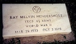

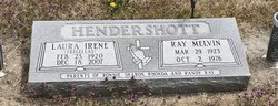
Ray Melvin Hendershott
| Birth | : | 29 May 1923 Paradise, Russell County, Kansas, USA |
| Death | : | 2 Oct 1976 Larned, Pawnee County, Kansas, USA |
| Burial | : | Natoma Cemetery, Natoma, Osborne County, USA |
| Coordinate | : | 39.1907700, -99.0162700 |
| Description | : | Melvin Hendershott, 53, died Sat. Oct. 2, at St. Joseph Hospital in Larned. He had spent the past few years in Larned but most of his life was around Natoma. He was born Mar. 29, 1923 at Paradise. He married Irene Ewing Aug. 16, 1945 in Natoma. Survivors are the widow; a son, Ronnie, Wichita; two daughters, Mrs. Gene (Sharon) Angel, and Mrs. Glen (Rhonda) Strecker, both of Paradise; 2 grandchildren; two brothers, Roy, Buena Park, CA; and Everett, Louisville, KY; sister, Mrs. Ted (Lois) Lindshield, Lindsborg. Services at the Church of God with Rev.... Read More |
frequently asked questions (FAQ):
-
Where is Ray Melvin Hendershott's memorial?
Ray Melvin Hendershott's memorial is located at: Natoma Cemetery, Natoma, Osborne County, USA.
-
When did Ray Melvin Hendershott death?
Ray Melvin Hendershott death on 2 Oct 1976 in Larned, Pawnee County, Kansas, USA
-
Where are the coordinates of the Ray Melvin Hendershott's memorial?
Latitude: 39.1907700
Longitude: -99.0162700
Family Members:
Parent
Spouse
Siblings
Children
Flowers:


Nearby Cemetories:
1. Natoma Cemetery
Natoma, Osborne County, USA
Coordinate: 39.1907700, -99.0162700
2. Natoma Lutheran Cemetery
Natoma, Osborne County, USA
Coordinate: 39.1907700, -99.0162700
3. Natoma Catholic Cemetery
Natoma, Osborne County, USA
Coordinate: 39.2054050, -99.0289480
4. Immanuel Lutheran Cemetery
Natoma, Osborne County, USA
Coordinate: 39.2708015, -99.0096970
5. Mount Hermon Cemetery
Paradise, Russell County, USA
Coordinate: 39.1324997, -98.9439011
6. Bowlby Ranch Cemetery
Ellis County, USA
Coordinate: 39.1127430, -99.0513540
7. Round Mound Cemetery
Osborne County, USA
Coordinate: 39.2630997, -98.9636002
8. Conger Cemetery
Plainville, Rooks County, USA
Coordinate: 39.1978700, -99.1232100
9. IXL Cemetery
Natoma, Osborne County, USA
Coordinate: 39.2491989, -98.9218979
10. Aurora Cemetery
Laton, Rooks County, USA
Coordinate: 39.2778015, -99.0847015
11. Shiloh Cemetery
Codell, Rooks County, USA
Coordinate: 39.2350006, -99.1410980
12. Victor Cemetery
Osborne County, USA
Coordinate: 39.2380981, -98.8613968
13. Norman Cemetery
Ellis County, USA
Coordinate: 39.1044006, -99.1575012
14. Chalk Mound Cemetery
Laton, Rooks County, USA
Coordinate: 39.3208008, -99.0852966
15. Fairport Cemetery
Russell County, USA
Coordinate: 39.0463982, -99.0207977
16. Cedar Bluff Cemetery
Osborne County, USA
Coordinate: 39.2496986, -98.8431015
17. Pleasant Plain Cemetery
Osborne County, USA
Coordinate: 39.3367004, -99.0372009
18. Paradise Center Cemetery
Codell, Rooks County, USA
Coordinate: 39.2050570, -99.2058100
19. Cole Cemetery
Osborne County, USA
Coordinate: 39.2352982, -98.8060989
20. Waldo Catholic Cemetery
Waldo Township, Russell County, USA
Coordinate: 39.1036600, -98.8162400
21. Covert Cemetery
Osborne County, USA
Coordinate: 39.2896996, -98.8107986
22. Mount Ayr Cemetery
Alton, Osborne County, USA
Coordinate: 39.3764000, -98.9717026
23. Twin Mound Cemetery
Rooks County, USA
Coordinate: 39.2855988, -99.2319031
24. Survey Cemetery
Woodston, Rooks County, USA
Coordinate: 39.3722000, -99.1333008