
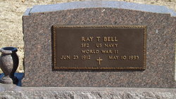

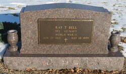
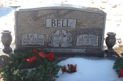
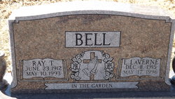
Ray Thomas Bell
| Birth | : | 23 Jun 1912 |
| Death | : | 10 May 1993 |
| Burial | : | Sullivan Cemetery, Winthrop, Okanogan County, USA |
| Coordinate | : | 48.4742012, -120.1707993 |
| Plot | : | Section D |
| Description | : | the following obituary was provided by Find A Grave contributor, KUfan: Onaga Herald, May 13, 1993: Obituary-Ray T. Bell Ray T. Bell, 80, Holton, died Monday, May 10, 1993, at the Holton Hospital. Mr. Bell was a welder for Standard Oil Co. He was a Navy veteran of World War II, having served on the USS Fredrick T. Turner a Guam and Guadalcanal in the Pacific. He was born June 23, 1912, in WaKeeney, the son of Harry E. and Nellie Shell Bell. He spent most of his life in Denison and Arrington communities. Mr. Bell was a member of First Christian Church in Holton. He was... Read More |
frequently asked questions (FAQ):
-
Where is Ray Thomas Bell's memorial?
Ray Thomas Bell's memorial is located at: Sullivan Cemetery, Winthrop, Okanogan County, USA.
-
When did Ray Thomas Bell death?
Ray Thomas Bell death on 10 May 1993 in
-
Where are the coordinates of the Ray Thomas Bell's memorial?
Latitude: 48.4742012
Longitude: -120.1707993
Family Members:
Parent

Spouse
Siblings
Flowers:


Nearby Cemetories:
1. Sullivan Cemetery
Winthrop, Okanogan County, USA
Coordinate: 48.4742012, -120.1707993
2. Old Winthrop Cemetery
Winthrop, Okanogan County, USA
Coordinate: 48.4748000, -120.1864700
3. Beaver Creek Cemetery
Twisp, Okanogan County, USA
Coordinate: 48.3272000, -120.0564000
4. Conconully Cemetery
Conconully, Okanogan County, USA
Coordinate: 48.5441600, -119.7400100
5. Ruby Cemetery
Okanogan County, USA
Coordinate: 48.5085983, -119.7221985
6. Chiliwist Cemetery
Okanogan County, USA
Coordinate: 48.2630997, -119.7363968
7. Malott Community Cemetery
Malott, Okanogan County, USA
Coordinate: 48.2925000, -119.7047300
8. Paradise Hill Cemetery
Brewster, Okanogan County, USA
Coordinate: 48.1848980, -119.8411900
9. Spring Coulee Family Cemetery
Okanogan County, USA
Coordinate: 48.3895950, -119.6289460
10. Methow Cemetery
Methow, Okanogan County, USA
Coordinate: 48.1102982, -120.0124969
11. Pine Creek Cemetery
Tonasket, Okanogan County, USA
Coordinate: 48.6330560, -119.6502780
12. Okanogan City Cemetery
Okanogan, Okanogan County, USA
Coordinate: 48.3546982, -119.6061020
13. Okanogan Valley Memorial Gardens
Omak, Okanogan County, USA
Coordinate: 48.3911018, -119.5691986
14. Omak Memorial Cemetery
Okanogan, Okanogan County, USA
Coordinate: 48.3874000, -119.5565800
15. South Pine Creek Cemetery
Riverside, Okanogan County, USA
Coordinate: 48.5925900, -119.5663400
16. Stoddard Gravesite
Okanogan, Okanogan County, USA
Coordinate: 48.4531140, -119.5411680
17. Elizabeth Osborn Mikel Gravesite
Brewster, Okanogan County, USA
Coordinate: 48.1498900, -119.7514700
18. Riverside Cemetery
Riverside, Okanogan County, USA
Coordinate: 48.4944400, -119.5022200
19. Cameron Lake Pioneer Memorial Cemetery
Malott, Okanogan County, USA
Coordinate: 48.2708330, -119.5700000
20. Locust Grove Cemetery
Brewster, Okanogan County, USA
Coordinate: 48.1114006, -119.7746964
21. Miller Family Cemetery
Okanogan County, USA
Coordinate: 48.0530300, -119.9288000
22. Dick Family Cemetery
Okanogan County, USA
Coordinate: 48.0502700, -119.9241700
23. Pateros Cemetery
Pateros, Okanogan County, USA
Coordinate: 48.0516600, -119.9097300
24. Sand Flats Cemetery
Omak, Okanogan County, USA
Coordinate: 48.4157600, -119.4836600