
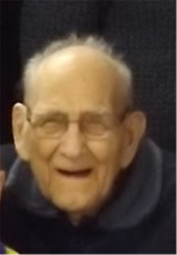

Raymond E “Ray” Stoebner
| Birth | : | 11 Dec 1924 Tripp, Hutchinson County, South Dakota, USA |
| Death | : | 8 May 2018 Sioux Falls, Minnehaha County, South Dakota, USA |
| Burial | : | Friedens Reformed Cemetery, Tripp, Hutchinson County, USA |
| Coordinate | : | 43.2113991, -97.9657974 |
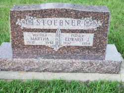
| Description | : | Raymond "Ray" E. Stoebner, 93, of Tripp, South Dakota passed away on Tuesday, May 8, 2018 at Ava's House by Sanford in Sioux Falls, South Dakota. Ray was born on December 11, 1924 to Edward and Martha (Brandt) Stoebner in Tripp, South Dakota. He attended Tripp High School. In 1944, he enlisted in the U.S. Army. He was honorably discharged in 1946 and returned home to the farm. On February 8, 1948, he was united in marriage to Agnes Hahn at the Zion Lutheran Church in Delmont, South Dakota. Together they farmed north of Delmont until 1986 when... Read More |
frequently asked questions (FAQ):
-
Where is Raymond E “Ray” Stoebner's memorial?
Raymond E “Ray” Stoebner's memorial is located at: Friedens Reformed Cemetery, Tripp, Hutchinson County, USA.
-
When did Raymond E “Ray” Stoebner death?
Raymond E “Ray” Stoebner death on 8 May 2018 in Sioux Falls, Minnehaha County, South Dakota, USA
-
Where are the coordinates of the Raymond E “Ray” Stoebner's memorial?
Latitude: 43.2113991
Longitude: -97.9657974
Family Members:
Parent

Spouse

Siblings
Flowers:


Nearby Cemetories:
1. Friedens Reformed Cemetery
Tripp, Hutchinson County, USA
Coordinate: 43.2113991, -97.9657974
2. Grace Hill Cemetery
Tripp, Hutchinson County, USA
Coordinate: 43.2111015, -97.9638977
3. Cathedral Catholic Cemetery
Tripp, Hutchinson County, USA
Coordinate: 43.2121100, -97.9619600
4. Zion Lutheran Cemetery
Tripp, Hutchinson County, USA
Coordinate: 43.1974400, -97.9917300
5. Haffner Family Farm Cemetery
Hutchinson County, USA
Coordinate: 43.2134840, -98.0312720
6. Pietz Cemetery
Hutchinson County, USA
Coordinate: 43.2703018, -97.9599991
7. Postahl Lutheran Cemetery
Kaylor, Hutchinson County, USA
Coordinate: 43.1834710, -97.8880710
8. Nagel Family Cemetery
Avon, Bon Homme County, USA
Coordinate: 43.1558851, -98.0101013
9. Oak Hollow Cemetery
Hutchinson County, USA
Coordinate: 43.1963997, -98.0599976
10. Dennewitz Cemetery
Hutchinson County, USA
Coordinate: 43.2400017, -97.8735962
11. Immanuel Reformed Church Cemetery
Bon Homme County, USA
Coordinate: 43.1250000, -97.9392014
12. Bethel Reformed Cemetery #1
Hutchinson County, USA
Coordinate: 43.2840710, -97.8878830
13. Emil G. Mogck Farm Cemetery
Hutchinson County, USA
Coordinate: 43.2308210, -97.8326250
14. Saints Cyril and Methodius Cemetery
Scotland, Bon Homme County, USA
Coordinate: 43.1305560, -97.8819440
15. Hoffnungsberg Cemetery
Hutchinson County, USA
Coordinate: 43.2972600, -98.0485700
16. Lake Baptist Cemetery
Hutchinson County, USA
Coordinate: 43.3106003, -97.9147034
17. Saint Johns Lutheran Cemetery
Kaylor, Hutchinson County, USA
Coordinate: 43.1763992, -97.8274994
18. Hoffnungstahl Cemetery
Kaylor, Hutchinson County, USA
Coordinate: 43.2708015, -97.8367004
19. Christina Koth Gravesite
Parkston, Hutchinson County, USA
Coordinate: 43.3203870, -97.9154910
20. Simental Cemetery
Hutchinson County, USA
Coordinate: 43.2132988, -97.8052979
21. New Salem Reformed Cemetery
Charles Mix County, USA
Coordinate: 43.1683006, -98.1271973
22. Bethel Reformed Cemetery #2
Hutchinson County, USA
Coordinate: 43.2967900, -97.8348800
23. Rosenfeld Cemetery
Hutchinson County, USA
Coordinate: 43.3381004, -97.9344025
24. Wittmeier Cemetery
Scotland, Bon Homme County, USA
Coordinate: 43.0825000, -97.9186900