
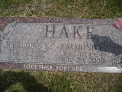
Raymond Earl Hake
| Birth | : | 30 May 1924 Creston, Platte County, Nebraska, USA |
| Death | : | 29 Nov 2000 Creston, Platte County, Nebraska, USA |
| Burial | : | Saint Anns Cemetery, Vail, Crawford County, USA |
| Coordinate | : | 42.0513992, -95.1868973 |
| Description | : | Son of Siegfried & Anna (Boning) Hake. Married to Jeraldine Beran on 12-26-1949. |
frequently asked questions (FAQ):
-
Where is Raymond Earl Hake's memorial?
Raymond Earl Hake's memorial is located at: Saint Anns Cemetery, Vail, Crawford County, USA.
-
When did Raymond Earl Hake death?
Raymond Earl Hake death on 29 Nov 2000 in Creston, Platte County, Nebraska, USA
-
Where are the coordinates of the Raymond Earl Hake's memorial?
Latitude: 42.0513992
Longitude: -95.1868973
Family Members:
Parent

Spouse

Siblings

Children
Flowers:


Nearby Cemetories:
1. Saint Anns Cemetery
Vail, Crawford County, USA
Coordinate: 42.0513992, -95.1868973
2. Vail Cemetery
Vail, Crawford County, USA
Coordinate: 42.0647011, -95.2102966
3. King Cemetery
Vail, Crawford County, USA
Coordinate: 42.1007996, -95.2319031
4. Hayes Township Cemetery
Westside, Crawford County, USA
Coordinate: 42.0083199, -95.1216583
5. Westside Cemetery
Westside, Crawford County, USA
Coordinate: 42.0602989, -95.0922012
6. Old Catholic Cemetery
Denison, Crawford County, USA
Coordinate: 42.0043983, -95.3189011
7. Deloit Cemetery
Deloit, Crawford County, USA
Coordinate: 42.1075325, -95.3136520
8. Saint Rose of Lima Cemetery
Denison, Crawford County, USA
Coordinate: 42.0247002, -95.3394012
9. Saint Johns Catholic Cemetery
Arcadia, Carroll County, USA
Coordinate: 42.0855406, -95.0341577
10. Crawford Heights Memory Gardens
Denison, Crawford County, USA
Coordinate: 42.0008011, -95.3469009
11. Zion Lutheran Cemetery
Denison, Crawford County, USA
Coordinate: 41.9958000, -95.3450012
12. Oakland Cemetery
Denison, Crawford County, USA
Coordinate: 41.9972000, -95.3478012
13. Arcadia Cemetery
Arcadia Township, Carroll County, USA
Coordinate: 42.1000680, -95.0130550
14. Saint John Lutheran Church Cemetery
Crawford County, USA
Coordinate: 42.1780000, -95.2650000
15. Iowa Township Cemetery
Aspinwall, Crawford County, USA
Coordinate: 41.9216995, -95.1113968
16. Nishnabotna Cemetery
Manilla, Crawford County, USA
Coordinate: 41.9086952, -95.2464447
17. Kiron Cemetery
Kiron, Crawford County, USA
Coordinate: 42.1817017, -95.3133011
18. Mount Olivet Cemetery
Manilla, Crawford County, USA
Coordinate: 41.8922005, -95.2200012
19. Wheatland Cemetery
Carroll County, USA
Coordinate: 42.1814003, -95.0582962
20. Washington Township Cemetery
Buck Grove, Crawford County, USA
Coordinate: 41.9354000, -95.3387000
21. Saint Augustine Cemetery
Halbur, Carroll County, USA
Coordinate: 42.0066986, -94.9744034
22. Lehfeldt Cemetery
Kiron, Crawford County, USA
Coordinate: 42.1458170, -95.3724972
23. Sacred Heart Cemetery
Manning, Carroll County, USA
Coordinate: 41.9132500, -95.0540000
24. Manning Cemetery
Manning, Carroll County, USA
Coordinate: 41.8990000, -95.0620000