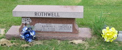
Raymond Edwin “Rocky” Rothwell
| Birth | : | 16 Oct 1924 Douglas County, Kansas, USA |
| Death | : | 8 Jul 1993 Topeka, Shawnee County, Kansas, USA |
| Burial | : | Pine Grove Cemetery, Thessalon, Algoma District, Canada |
| Coordinate | : | 46.3111420, -83.5409620 |
| Description | : | Services for Rocky E. Rothwell, 68, Topeka, were Sunday at Penwell-Gabel Funeral Home here. Burial was in Bethel Cemetery. Mr. Rothwell died Thursday, July 8, 1993, at a Topeka hospital. He was born Oct. 16, 1924, in Douglas County, the son of Thurman and Mabel Carr Rothwell. He graduated in 1943 from Lecompton High School and received an electrical engineering degree while serving in the Navy. He and his wife owned and operated Rocky's Refrigeration in Topeka for 13 years. He later was a store engineer for two Topeka supermarkets until he retired in 1990. He also raised Limousin cattle... Read More |
frequently asked questions (FAQ):
-
Where is Raymond Edwin “Rocky” Rothwell's memorial?
Raymond Edwin “Rocky” Rothwell's memorial is located at: Pine Grove Cemetery, Thessalon, Algoma District, Canada.
-
When did Raymond Edwin “Rocky” Rothwell death?
Raymond Edwin “Rocky” Rothwell death on 8 Jul 1993 in Topeka, Shawnee County, Kansas, USA
-
Where are the coordinates of the Raymond Edwin “Rocky” Rothwell's memorial?
Latitude: 46.3111420
Longitude: -83.5409620
Family Members:
Siblings
Flowers:
Nearby Cemetories:
1. Pine Grove Cemetery
Thessalon, Algoma District, Canada
Coordinate: 46.3111420, -83.5409620
2. Little Rapids Cemetery
Little Rapids, Algoma District, Canada
Coordinate: 46.2971500, -83.5546100
3. Forest Lawn Cemetery
Thessalon, Algoma District, Canada
Coordinate: 46.2966640, -83.5545540
4. Maple Ridge Cemetery
Thessalon, Algoma District, Canada
Coordinate: 46.2787630, -83.4324530
5. Cloudslee Cemetery
Cloudslee, Algoma District, Canada
Coordinate: 46.3229580, -83.7078990
6. Humphrey Maple Grove Cemetery
Rydal Bank, Algoma District, Canada
Coordinate: 46.3818890, -83.7276440
7. Trunk Road Cemetery
Bruce Mines, Algoma District, Canada
Coordinate: 46.3079480, -83.7614200
8. Wharncliffe Cemetery
Wharncliffe, Algoma District, Canada
Coordinate: 46.4220820, -83.3754110
9. Sands Cemetery
Plummer, Algoma District, Canada
Coordinate: 46.4222200, -83.7193410
10. Dunn's Valley Cemetery
Dunns Valley, Algoma District, Canada
Coordinate: 46.4679832, -83.6253586
11. Rock Lake Cemetery
Rock Lake, Algoma District, Canada
Coordinate: 46.4361992, -83.7270660
12. Plummer Cemetery
Plummer, Algoma District, Canada
Coordinate: 46.4030510, -83.7705810
13. Bellingham United Church Cemetery
Bellingham, Algoma District, Canada
Coordinate: 46.3960860, -83.2854860
14. Bruce Mines Cemetery
Bruce Mines, Algoma District, Canada
Coordinate: 46.4167600, -83.7832200
15. Spruce Grove Cemetery
Iron Bridge, Algoma District, Canada
Coordinate: 46.2783570, -83.2384830
16. Arnill United Cemetery
Iron Bridge, Algoma District, Canada
Coordinate: 46.2780320, -83.2281310
17. Carlyle Cemetery
Algoma District, Canada
Coordinate: 46.2637700, -83.2177140
18. Saint Boniface Catholic Cemetery
Hilton Beach, Algoma District, Canada
Coordinate: 46.2518340, -83.8799940
19. Mount Pleasant Cemetery
Gordon Lake, Algoma District, Canada
Coordinate: 46.4087150, -83.8672590
20. Poplar Dale Cemetery
Poplar Dale, Algoma District, Canada
Coordinate: 46.5209300, -83.7317400
21. Sunset Cemetery
Iron Bridge, Algoma District, Canada
Coordinate: 46.2549870, -83.1864410
22. Saint John's Anglican Cemetery
Hilton Beach, Algoma District, Canada
Coordinate: 46.2537500, -83.8982600
23. Grace United Cemetery
Hilton Beach, Algoma District, Canada
Coordinate: 46.2524630, -83.9040880
24. Aberdeen Cemetery
Algoma District, Canada
Coordinate: 46.4661000, -83.8801000


