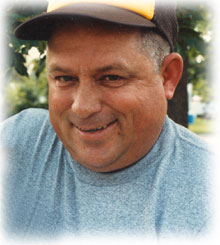
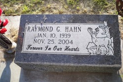
Raymond Glenn Hahn
| Birth | : | 10 Jan 1939 Ord, Valley County, Nebraska, USA |
| Death | : | 25 Nov 2004 Lincoln, Lancaster County, Nebraska, USA |
| Burial | : | Pleasant View Cemetery, Winside, Wayne County, USA |
| Coordinate | : | 42.1713982, -97.1917038 |
| Description | : | Son of Raymond M. & Irene (Whiting) Hahn. Ray was raised in Wheeler County, Nebraska by Thelma and Jay Horwart. He graduated from Wheeler County High School in 1957. On September 4, 1957, Ray entered the U.S. Air Force and was honorably discharged on October 17, 1957. On March 13, 1976, Ray married Norma Kretz in Columbus. They lived in Columbus for many years and moved to rural Bellwood in the early 1980's. Ray worked at Soil Mover's, Fleischer Manufacturing, Virg's Blacksmith Shop, and was the groundskeeper at the Elk's Country Club and at Quail Run Golf Course. He was... Read More |
frequently asked questions (FAQ):
-
Where is Raymond Glenn Hahn's memorial?
Raymond Glenn Hahn's memorial is located at: Pleasant View Cemetery, Winside, Wayne County, USA.
-
When did Raymond Glenn Hahn death?
Raymond Glenn Hahn death on 25 Nov 2004 in Lincoln, Lancaster County, Nebraska, USA
-
Where are the coordinates of the Raymond Glenn Hahn's memorial?
Latitude: 42.1713982
Longitude: -97.1917038
Family Members:
Parent
Spouse
Flowers:
Nearby Cemetories:
1. Pleasant View Cemetery
Winside, Wayne County, USA
Coordinate: 42.1713982, -97.1917038
2. Immanuel Cemetery
Wayne County, USA
Coordinate: 42.1594009, -97.2502975
3. Theophilus Cemetery
Winside, Wayne County, USA
Coordinate: 42.1929500, -97.0959000
4. Muller Cemetery
Pilger, Stanton County, USA
Coordinate: 42.0780940, -97.1781920
5. E U B Cemetery
Hoskins, Wayne County, USA
Coordinate: 42.1137900, -97.3015700
6. Elmwood Cemetery
Carroll, Wayne County, USA
Coordinate: 42.2719002, -97.1928024
7. Swedish Cemetery
Winside, Wayne County, USA
Coordinate: 42.1706400, -97.3297400
8. Bega Cemetery
Stanton County, USA
Coordinate: 42.0736008, -97.2343979
9. Bethany Presbyterian Cemetery
Carroll, Wayne County, USA
Coordinate: 42.2562600, -97.2710300
10. Trinity Cemetery
Hoskins, Wayne County, USA
Coordinate: 42.1055984, -97.3274994
11. Zion Lutheran Cemetery
Hoskins, Wayne County, USA
Coordinate: 42.1920100, -97.3593700
12. Spring Branch Cemetery
Spring Branch Township, Stanton County, USA
Coordinate: 42.0789400, -97.3297400
13. Greenwood Cemetery
Wayne, Wayne County, USA
Coordinate: 42.2372017, -97.0258026
14. Bethlehem Cemetery
Stanton County, USA
Coordinate: 42.0332985, -97.2241974
15. Hermann Sohne Cemetery
Altona, Wayne County, USA
Coordinate: 42.1051500, -97.0041700
16. First Trinity Lutheran Church Cemetery
Altona, Wayne County, USA
Coordinate: 42.1051200, -96.9906100
17. LaPorte Cemetery
Wayne County, USA
Coordinate: 42.2064018, -96.9574966
18. Norfolk State Hospital Old Cemetery
Norfolk, Madison County, USA
Coordinate: 42.0535400, -97.3733100
19. Pilger Cemetery
Pilger, Stanton County, USA
Coordinate: 42.0217018, -97.0591965
20. Hunters Grove Cemetery
Wayne, Wayne County, USA
Coordinate: 42.1963800, -96.9521900
21. Salem Cemetery
Wayne, Wayne County, USA
Coordinate: 42.1775100, -96.9495700
22. Christ Lutheran Cemetery
Stanton County, USA
Coordinate: 42.0433006, -97.3636017
23. Norfolk State Hospital New Cemetery
Norfolk, Madison County, USA
Coordinate: 42.0475500, -97.3698300
24. Zion Cemetery
Stanton County, USA
Coordinate: 42.0421982, -97.3638992


