

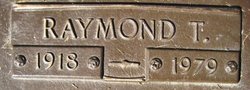

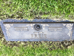
Raymond Theodore Freie
| Birth | : | 29 Jan 1918 Grant Township, Boone County, Iowa, USA |
| Death | : | 11 Jan 1979 Iowa, USA |
| Burial | : | St. John the Baptist Churchyard, Aylmerton, North Norfolk District, England |
| Coordinate | : | 52.9139032, 1.2435925 |
frequently asked questions (FAQ):
-
Where is Raymond Theodore Freie's memorial?
Raymond Theodore Freie's memorial is located at: St. John the Baptist Churchyard, Aylmerton, North Norfolk District, England.
-
When did Raymond Theodore Freie death?
Raymond Theodore Freie death on 11 Jan 1979 in Iowa, USA
-
Where are the coordinates of the Raymond Theodore Freie's memorial?
Latitude: 52.9139032
Longitude: 1.2435925
Family Members:
Parent
Spouse
Siblings

Children
Flowers:


Nearby Cemetories:
1. St. John the Baptist Churchyard
Aylmerton, North Norfolk District, England
Coordinate: 52.9139032, 1.2435925
2. St. Margaret Churchyard
Felbrigg, North Norfolk District, England
Coordinate: 52.9035450, 1.2660760
3. Cromer Cemetery
Cromer, North Norfolk District, England
Coordinate: 52.9204800, 1.2730300
4. All Saints Churchyard
Gresham, North Norfolk District, England
Coordinate: 52.9005410, 1.2210720
5. All Saints Churchyard
Beeston Regis, North Norfolk District, England
Coordinate: 52.9408700, 1.2340790
6. St. Andrew's Churchyard
Metton, North Norfolk District, England
Coordinate: 52.8880460, 1.2670590
7. St. Mary's Churchyard
Bessingham, North Norfolk District, England
Coordinate: 52.8871980, 1.2193150
8. Cromer Old Cemetery
Cromer, North Norfolk District, England
Coordinate: 52.9292270, 1.2897670
9. St. Peter's Churchyard
North Barningham, North Norfolk District, England
Coordinate: 52.8888040, 1.1954330
10. St. Peter and St. Paul Churchyard
Cromer, North Norfolk District, England
Coordinate: 52.9312500, 1.3011111
11. St. Mary Churchyard
Roughton, North Norfolk District, England
Coordinate: 52.8801901, 1.2976948
12. St. Bartholomew Churchyard
Hanworth, North Norfolk District, England
Coordinate: 52.8664290, 1.2718830
13. St. Mary's Churchyard
Barningham, North Norfolk District, England
Coordinate: 52.8757410, 1.1882470
14. All Saints Churchyard
Bodham, North Norfolk District, England
Coordinate: 52.9057700, 1.1596200
15. St. Martin's Churchyard
Overstrand, North Norfolk District, England
Coordinate: 52.9174550, 1.3314910
16. St. Peter's Churchyard
Matlaske, North Norfolk District, England
Coordinate: 52.8683511, 1.1946365
17. St. Mary's Churchyard
Aldborough, North Norfolk District, England
Coordinate: 52.8575340, 1.2354660
18. Saint Mary's Churchyard
Baconsthorpe, North Norfolk District, England
Coordinate: 52.8872500, 1.1606900
19. St. Mary's Churchyard
Northrepps, North Norfolk District, England
Coordinate: 52.9019100, 1.3361300
20. All Saints Churchyard
Alby with Thwaite, North Norfolk District, England
Coordinate: 52.8533000, 1.2555000
21. St. Ethelbert's Church Burial Ground
Alby with Thwaite, North Norfolk District, England
Coordinate: 52.8548760, 1.2701850
22. St. Michael's Churchyard
Plumstead, North Norfolk District, England
Coordinate: 52.8691700, 1.1669320
23. St Andrew's Churchyard
Gunton, North Norfolk District, England
Coordinate: 52.8584910, 1.3097280
24. St. Andrew’s Churchyard
Little Barningham, North Norfolk District, England
Coordinate: 52.8547270, 1.1795150