

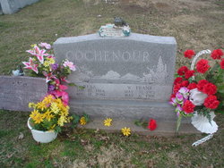
Reba Eileene Stott Cochenour
| Birth | : | 25 Jan 1924 Azen, Scotland County, Missouri, USA |
| Death | : | 12 Aug 2010 Memphis, Scotland County, Missouri, USA |
| Burial | : | Big Tygart Cemetery, Rockport, Wood County, USA |
| Coordinate | : | 39.1328011, -81.5457993 |
| Description | : | Reba Eileene Stott Cochenour, 86, of Arbela, MO, died Thursday, August 12, 2010 at the Scotland County Memorial Hospital in Memphis, MO. She was born on January 25, 1924 in Azen, MO, the daughter of Alvin and Ava Cowan Stott. On December 25, 1938 Reba was united in marriage to Wane Franklin Cochenour. He preceded her in death on May 6, 1991. She had been employed at Freuhauf Corporation in Ft. Madison, IA and Swifts in Keokuk, IA. Reba was a loving mother, grandmother and great-grandmother. She worked hard raising her children and watching her grandchildren. With all her children, if anyone stopped... Read More |
frequently asked questions (FAQ):
-
Where is Reba Eileene Stott Cochenour's memorial?
Reba Eileene Stott Cochenour's memorial is located at: Big Tygart Cemetery, Rockport, Wood County, USA.
-
When did Reba Eileene Stott Cochenour death?
Reba Eileene Stott Cochenour death on 12 Aug 2010 in Memphis, Scotland County, Missouri, USA
-
Where are the coordinates of the Reba Eileene Stott Cochenour's memorial?
Latitude: 39.1328011
Longitude: -81.5457993
Family Members:
Parent

Spouse
Siblings

Children
Flowers:


Nearby Cemetories:
1. Big Tygart Cemetery
Rockport, Wood County, USA
Coordinate: 39.1328011, -81.5457993
2. Stephens Cemetery
Mineral Wells, Wood County, USA
Coordinate: 39.1371994, -81.5606003
3. Graham Cemetery
Wood County, USA
Coordinate: 39.1556015, -81.5468979
4. Brand Cemetery
Mineral Wells, Wood County, USA
Coordinate: 39.1247670, -81.5125000
5. Deem Cemetery
Mineral Wells, Wood County, USA
Coordinate: 39.1455994, -81.5017014
6. Stephens Cemetery
Mineral Wells, Wood County, USA
Coordinate: 39.1694000, -81.5432500
7. Reeder Cemetery
Wood County, USA
Coordinate: 39.1725006, -81.5419006
8. Naylor Cemetery
Wood County, USA
Coordinate: 39.1074982, -81.5896988
9. Compton Cemetery
Mineral Wells, Wood County, USA
Coordinate: 39.1749992, -81.5314026
10. Spencer Cemetery
Chesterville, Wood County, USA
Coordinate: 39.1576690, -81.4975690
11. Chesterville Cemetery
Mineral Wells, Wood County, USA
Coordinate: 39.1603310, -81.4998870
12. Mount Zion Cemetery
Mineral Wells, Wood County, USA
Coordinate: 39.1739100, -81.5062000
13. Central Cemetery
Rockport, Wood County, USA
Coordinate: 39.0887500, -81.5814700
14. Slate Baptist Cemetery
Slate, Wood County, USA
Coordinate: 39.1022400, -81.4887500
15. Cooper Family Cemetery
Mineral Wells, Wood County, USA
Coordinate: 39.1774380, -81.5066670
16. Amos Cemetery
Rockport, Wood County, USA
Coordinate: 39.0964012, -81.5986023
17. Dye Cemetery
Mineral Wells, Wood County, USA
Coordinate: 39.1545790, -81.4803500
18. Mount Pleasant Cemetery
Mineral Wells, Wood County, USA
Coordinate: 39.1842000, -81.5194000
19. Blair Cemetery
Wood County, USA
Coordinate: 39.1469002, -81.6149979
20. Butcher Cemetery
Mineral Wells, Wood County, USA
Coordinate: 39.1899986, -81.5464020
21. Slate Chapel Cemetery
Slate, Wood County, USA
Coordinate: 39.1067000, -81.4791000
22. Sams Cemetery
Wood County, USA
Coordinate: 39.1885986, -81.5730972
23. Slate Chapel Cemetery Old
Slate, Wood County, USA
Coordinate: 39.1084000, -81.4747000
24. Lott Cemetery
Wood County, USA
Coordinate: 39.1039009, -81.6157990