
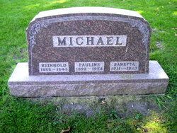
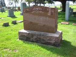
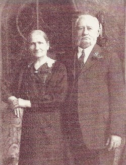
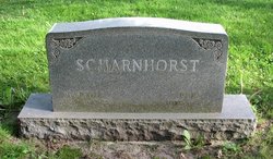
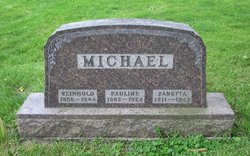
Reinhold Albert Michael
| Birth | : | 12 Apr 1888 Germany |
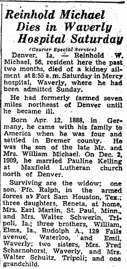
| Death | : | 29 Jul 1944 Waverly, Bremer County, Iowa, USA |
| Burial | : | Te Puke Cemetery, Te Puke, Western Bay of Plenty District, New Zealand |
| Coordinate | : | -37.8054430, 176.3078800 |
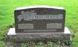
| Description | : | father: Wilhelm Michael mother: Friederika Volbrecht marriage: 2 Dec 1908 Maxfield Twp, Bremer, Ia spouse: Pauline W. Kelling parents: Joachim & Wilhelmine (Klausing) Kelling Census 1930 Fremont, Bremer, Iowa Age: 42 Marital Status: Married Race: White Birthplace: Germany Immigration Year: 1892 Father's Birthplace: Germany Mother's Birthplace: Germany Head Reinhold A Michael M 42 Germany Wife Pauline Michael F 37 Iowa Daughter Renetta Michael F 18 Iowa Daughter Ruth Michael F 15 Iowa Son Ralph Michael M 12 Iowa Daughter Rosetta Michael F 9 ... Read More |
frequently asked questions (FAQ):
-
Where is Reinhold Albert Michael's memorial?
Reinhold Albert Michael's memorial is located at: Te Puke Cemetery, Te Puke, Western Bay of Plenty District, New Zealand.
-
When did Reinhold Albert Michael death?
Reinhold Albert Michael death on 29 Jul 1944 in Waverly, Bremer County, Iowa, USA
-
Where are the coordinates of the Reinhold Albert Michael's memorial?
Latitude: -37.8054430
Longitude: 176.3078800
Family Members:
Parent
Spouse

Siblings

Children
Flowers:


Nearby Cemetories:
1. Te Puke Cemetery
Te Puke, Western Bay of Plenty District, New Zealand
Coordinate: -37.8054430, 176.3078800
2. Old Te Puke Cemetery
Te Puke, Western Bay of Plenty District, New Zealand
Coordinate: -37.7884910, 176.3354700
3. Te Kahika Māori Cemetery
Te Puke, Western Bay of Plenty District, New Zealand
Coordinate: -37.7884600, 176.3445600
4. Mangatawa Marae Urupa
Kairua, Tauranga City, New Zealand
Coordinate: -37.6996840, 176.2507010
5. Ngapeke Asher Family Cemetery
Welcome Bay, Tauranga City, New Zealand
Coordinate: -37.7121560, 176.2225240
6. Otukōpiri Urupā
Welcome Bay, Tauranga City, New Zealand
Coordinate: -37.7133500, 176.2162900
7. Maketu Cemetery
Maketu, Western Bay of Plenty District, New Zealand
Coordinate: -37.7634700, 176.4511500
8. St. Thomas's Anglican Churchyard
Maketu, Western Bay of Plenty District, New Zealand
Coordinate: -37.7600849, 176.4555692
9. Maungatapu (Waitaia) Māori Cemetery
Tauranga, Tauranga City, New Zealand
Coordinate: -37.7217300, 176.1708000
10. Hairini
Hairini, Tauranga City, New Zealand
Coordinate: -37.7241530, 176.1656207
11. Otumoko Urupa
Matapihi, Tauranga City, New Zealand
Coordinate: -37.6857230, 176.2064760
12. Waikari Marae Urupa
Matapihi, Tauranga City, New Zealand
Coordinate: -37.6966650, 176.1840190
13. Okahu Urupa
Matapihi, Tauranga City, New Zealand
Coordinate: -37.6891560, 176.1866182
14. Anglican Cemetery
Tauranga, Tauranga City, New Zealand
Coordinate: -37.7111520, 176.1575680
15. Matapihi Māori Cemetery
Matapihi, Tauranga City, New Zealand
Coordinate: -37.6772600, 176.2048900
16. Catholic Cemetery
Tauranga, Tauranga City, New Zealand
Coordinate: -37.7111740, 176.1552620
17. Latter Day Saints Cemetery
Tauranga, Tauranga City, New Zealand
Coordinate: -37.7095940, 176.1557600
18. Presbyterian Cemetery
Tauranga, Tauranga City, New Zealand
Coordinate: -37.7099350, 176.1536910
19. Old Cemetery Methodist Reserve
Tauranga, Tauranga City, New Zealand
Coordinate: -37.7088290, 176.1533750
20. Pyes Pa Memorial Park
Tauranga, Tauranga City, New Zealand
Coordinate: -37.7689800, 176.1162770
21. Mission Cemetery
Tauranga, Tauranga City, New Zealand
Coordinate: -37.6749040, 176.1706930
22. Te Pirau Māori Cemetery
Rangiwaea Marae, Western Bay of Plenty District, New Zealand
Coordinate: -37.6362200, 176.1230700
23. Okere Māori Cemetery
Okere Falls, Rotorua District, New Zealand
Coordinate: -38.0332900, 176.3464800
24. Motutawa Māori Cemetery
Mourea, Rotorua District, New Zealand
Coordinate: -38.0458300, 176.3381400