Releaf Nutting Moors
| Birth | : | 28 Sep 1758 Groton, Middlesex County, Massachusetts, USA |
| Death | : | 5 Nov 1849 Otisfield, Oxford County, Maine, USA |
| Burial | : | Bell Hill Cemetery, Otisfield, Oxford County, USA |
| Coordinate | : | 44.0883130, -70.5602760 |
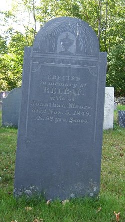
| Inscription | : | ERECTED in memory of RELEAF, wife of Jonathan Moors, died Nov. 5, 1849, AE. 92 yrs. 2 mos. |
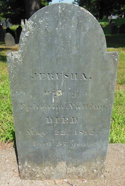
| Description | : | Relief was the daughter of Ephraim Nutting of Groton, Middlesex County, Massachusetts and Jerusha Parker Nutting of Groton, Middlesex County, Massachusetts. Jerusha and Ephraim were married on 29 May 1754 in Groton, Middlesex County, Massachusetts. Jerusha and Ephraim had five children. They were: Jonathan Nutting was born on 19 May 1755; Relief Nutting was born on 28 September 1758; Nathan Nutting was born on 16 March 1761; Ephraim Nutting was born on 18 August 1765; and Peter Nutting was born on 21 September 1766. All the children were born in Groton, Middlesex County, Massachusetts. Relief married Major Jonathan... Read More |
frequently asked questions (FAQ):
-
Where is Releaf Nutting Moors's memorial?
Releaf Nutting Moors's memorial is located at: Bell Hill Cemetery, Otisfield, Oxford County, USA.
-
When did Releaf Nutting Moors death?
Releaf Nutting Moors death on 5 Nov 1849 in Otisfield, Oxford County, Maine, USA
-
Where are the coordinates of the Releaf Nutting Moors's memorial?
Latitude: 44.0883130
Longitude: -70.5602760
Family Members:
Parent
Spouse
Siblings
Children
Flowers:
Nearby Cemetories:
1. Elmwood Cemetery
Otisfield, Oxford County, USA
Coordinate: 44.1019630, -70.5504070
2. Wight Cemetery
Otisfield, Oxford County, USA
Coordinate: 44.0890990, -70.5381570
3. Highland Cemetery
Otisfield, Oxford County, USA
Coordinate: 44.1007100, -70.5796200
4. Scribner Hill Cemetery Lower Yard
Otisfield, Oxford County, USA
Coordinate: 44.0769660, -70.5261470
5. East Otisfield Cemetery
Otisfield, Oxford County, USA
Coordinate: 44.0950300, -70.5237500
6. Oakdale Cemetery
Otisfield, Oxford County, USA
Coordinate: 44.1013900, -70.6014500
7. Cobb Hill Cemetery
Otisfield, Oxford County, USA
Coordinate: 44.0746000, -70.5095000
8. Bolster's Mills Cemetery
Harrison, Cumberland County, USA
Coordinate: 44.1171700, -70.5987020
9. Oak Hill Cemetery
Otisfield, Oxford County, USA
Coordinate: 44.0464040, -70.5762640
10. Cedar Crest Cemetery
Otisfield, Oxford County, USA
Coordinate: 44.0442009, -70.5438995
11. Maple Ridge Cemetery
Harrison, Cumberland County, USA
Coordinate: 44.0936012, -70.6278000
12. Richville Cemetery
Oxford, Oxford County, USA
Coordinate: 44.1340390, -70.5226510
13. Carsley Cemetery
Harrison, Cumberland County, USA
Coordinate: 44.0586560, -70.6224610
14. South Harrison Cemetery
Harrison, Cumberland County, USA
Coordinate: 44.0539017, -70.6188965
15. South Otisfield Cemetery
Otisfield, Oxford County, USA
Coordinate: 44.0428560, -70.5131290
16. Merrill Memorial Cemetery
Otisfield, Oxford County, USA
Coordinate: 44.1474250, -70.5608830
17. Stuarts Corner Cemetery
Bolsters Mills, Cumberland County, USA
Coordinate: 44.1417700, -70.5975200
18. Caswells Corner Cemetery
Harrison, Cumberland County, USA
Coordinate: 44.1312003, -70.6191605
19. Ryefield Cemetery
Cumberland County, USA
Coordinate: 44.1417007, -70.5994034
20. Unidentified Cemetery
Harrison, Cumberland County, USA
Coordinate: 44.1222448, -70.6322634
21. Perley Cemetery
Harrison, Cumberland County, USA
Coordinate: 44.1222220, -70.6324794
22. Johnson Cemetery
Harrison, Cumberland County, USA
Coordinate: 44.0638910, -70.6459670
23. Trafton Cemetery
Harrison, Cumberland County, USA
Coordinate: 44.0596910, -70.6436170
24. Summit Hill Cemetery
Harrison, Cumberland County, USA
Coordinate: 44.1269770, -70.6354860

