

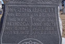

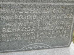
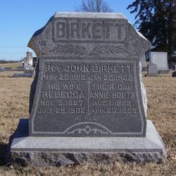
Rev John Birkett
| Birth | : | 23 Nov 1818 Kendal, South Lakeland District, Cumbria, England |
| Death | : | 25 Jan 1902 Holton, Jackson County, Kansas, USA |
| Burial | : | Sullivan Cemetery, Winthrop, Okanogan County, USA |
| Coordinate | : | 48.4742012, -120.1707993 |
| Plot | : | Section 3, Block 6, Lot 66 |
| Description | : | The Holton Recorder, January 30, 1902: The Rev. John Birkett was born at Kendall, in the north of England, November 23, 1818. His father had been a Wesleyan Methodist preacher, who had to locate because of poor health. When a boy of only thirteen his mother died and the lad was apprenticed to a cabinet maker, which business he continued until he emigrated to America. At 19 years of age he was converted and united with the Wesleyan church. Very soon after his conversion he was licensed as a local preacher and placed on the plan of the Manchester circuit, which... Read More |
frequently asked questions (FAQ):
-
Where is Rev John Birkett's memorial?
Rev John Birkett's memorial is located at: Sullivan Cemetery, Winthrop, Okanogan County, USA.
-
When did Rev John Birkett death?
Rev John Birkett death on 25 Jan 1902 in Holton, Jackson County, Kansas, USA
-
Where are the coordinates of the Rev John Birkett's memorial?
Latitude: 48.4742012
Longitude: -120.1707993
Family Members:
Parent

Spouse

Siblings
Children
Flowers:


Nearby Cemetories:
1. Sullivan Cemetery
Winthrop, Okanogan County, USA
Coordinate: 48.4742012, -120.1707993
2. Old Winthrop Cemetery
Winthrop, Okanogan County, USA
Coordinate: 48.4748000, -120.1864700
3. Beaver Creek Cemetery
Twisp, Okanogan County, USA
Coordinate: 48.3272000, -120.0564000
4. Conconully Cemetery
Conconully, Okanogan County, USA
Coordinate: 48.5441600, -119.7400100
5. Ruby Cemetery
Okanogan County, USA
Coordinate: 48.5085983, -119.7221985
6. Chiliwist Cemetery
Okanogan County, USA
Coordinate: 48.2630997, -119.7363968
7. Malott Community Cemetery
Malott, Okanogan County, USA
Coordinate: 48.2925000, -119.7047300
8. Paradise Hill Cemetery
Brewster, Okanogan County, USA
Coordinate: 48.1848980, -119.8411900
9. Spring Coulee Family Cemetery
Okanogan County, USA
Coordinate: 48.3895950, -119.6289460
10. Methow Cemetery
Methow, Okanogan County, USA
Coordinate: 48.1102982, -120.0124969
11. Pine Creek Cemetery
Tonasket, Okanogan County, USA
Coordinate: 48.6330560, -119.6502780
12. Okanogan City Cemetery
Okanogan, Okanogan County, USA
Coordinate: 48.3546982, -119.6061020
13. Okanogan Valley Memorial Gardens
Omak, Okanogan County, USA
Coordinate: 48.3911018, -119.5691986
14. Omak Memorial Cemetery
Okanogan, Okanogan County, USA
Coordinate: 48.3874000, -119.5565800
15. South Pine Creek Cemetery
Riverside, Okanogan County, USA
Coordinate: 48.5925900, -119.5663400
16. Stoddard Gravesite
Okanogan, Okanogan County, USA
Coordinate: 48.4531140, -119.5411680
17. Elizabeth Osborn Mikel Gravesite
Brewster, Okanogan County, USA
Coordinate: 48.1498900, -119.7514700
18. Riverside Cemetery
Riverside, Okanogan County, USA
Coordinate: 48.4944400, -119.5022200
19. Cameron Lake Pioneer Memorial Cemetery
Malott, Okanogan County, USA
Coordinate: 48.2708330, -119.5700000
20. Locust Grove Cemetery
Brewster, Okanogan County, USA
Coordinate: 48.1114006, -119.7746964
21. Miller Family Cemetery
Okanogan County, USA
Coordinate: 48.0530300, -119.9288000
22. Dick Family Cemetery
Okanogan County, USA
Coordinate: 48.0502700, -119.9241700
23. Pateros Cemetery
Pateros, Okanogan County, USA
Coordinate: 48.0516600, -119.9097300
24. Sand Flats Cemetery
Omak, Okanogan County, USA
Coordinate: 48.4157600, -119.4836600