

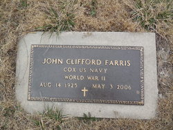

Rev John Clifford Farris
| Birth | : | 14 Aug 1925 Russellville, Cole County, Missouri, USA |
| Death | : | 3 May 2006 Jefferson City, Cole County, Missouri, USA |
| Burial | : | Crown Hill Cemetery, Madison, Madison County, USA |
| Coordinate | : | 41.8171997, -97.4439011 |
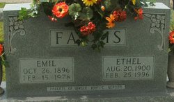
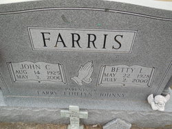
| Description | : | The Rev. John Clifford Farris, 80, son of Emil and Ethel Blank Farris, was born Aug. 14, 1925, near Russellville. He died May 3, 2006, at Jefferson City Nursing and Rehabilitation Center. The Rev. Farris was a 1943 graduate of Russellville High School and was a Navy veteran. He served during World War II in the South Pacific. He married Betty Blankenship April 20, 1947. She preceded him in death July 2, 2000. He worked for Eldon Ford Motor Co. before moving to Salem, where he was an equipment supervisor for the south-central state region of the Missouri Department of Conservation for 19.5... Read More |
frequently asked questions (FAQ):
-
Where is Rev John Clifford Farris's memorial?
Rev John Clifford Farris's memorial is located at: Crown Hill Cemetery, Madison, Madison County, USA.
-
When did Rev John Clifford Farris death?
Rev John Clifford Farris death on 3 May 2006 in Jefferson City, Cole County, Missouri, USA
-
Where are the coordinates of the Rev John Clifford Farris's memorial?
Latitude: 41.8171997
Longitude: -97.4439011
Family Members:
Parent

Spouse
Siblings


Children


Nearby Cemetories:
1. Crown Hill Cemetery
Madison, Madison County, USA
Coordinate: 41.8171997, -97.4439011
2. Saint Leonards Cemetery
Madison, Madison County, USA
Coordinate: 41.8182983, -97.4464035
3. Barnes Reserve Cemetery
Madison, Madison County, USA
Coordinate: 41.8227500, -97.4582000
4. Pleasant Valley Cemetery
Madison County, USA
Coordinate: 41.8877983, -97.3972015
5. Tracy Valley Cemetery
Humphrey, Platte County, USA
Coordinate: 41.7214012, -97.4480972
6. Green Garden Cemetery
Madison County, USA
Coordinate: 41.8100014, -97.5796967
7. Zion Evangelical Cemetery
Madison, Madison County, USA
Coordinate: 41.8010000, -97.5793000
8. Fairview Cemetery
Madison County, USA
Coordinate: 41.8883018, -97.5622025
9. Fairview Cemetery
Creston, Platte County, USA
Coordinate: 41.7136002, -97.3506012
10. Humphrey Cemetery
Humphrey, Platte County, USA
Coordinate: 41.6963997, -97.4931030
11. Saint Francis Cemetery
Humphrey, Platte County, USA
Coordinate: 41.6921997, -97.4935989
12. Kalamazoo Cemetery
Madison County, USA
Coordinate: 41.7787000, -97.6195000
13. Norwegian Cemetery
Stanton, Stanton County, USA
Coordinate: 41.9171600, -97.2907160
14. Saint Pauls Lutheran Cemetery
Platte County, USA
Coordinate: 41.7425003, -97.6286011
15. Iowa Valley Cemetery
Madison County, USA
Coordinate: 41.8292007, -97.6588974
16. Sacred Heart Cemetery
Cornlea, Platte County, USA
Coordinate: 41.6808014, -97.5708008
17. Granville Cemetery
Cornlea, Platte County, USA
Coordinate: 41.6712450, -97.5542160
18. Allbery Cemetery
Norfolk, Madison County, USA
Coordinate: 41.9738998, -97.5246964
19. Osborn Cemetery
Madison County, USA
Coordinate: 41.8807983, -97.6528015
20. Creston Pioneer Cemetery
Platte County, USA
Coordinate: 41.6892014, -97.2917023
21. Saint Bernard Cemetery
Lindsay, Platte County, USA
Coordinate: 41.7155991, -97.6286011
22. Saint Mary of the Angels Cemetery
Humphrey, Platte County, USA
Coordinate: 41.6444000, -97.4584000
23. Erychleb Cemetery
Stanton County, USA
Coordinate: 41.8664017, -97.2138977
24. Evangelical Cemetery
Madison County, USA
Coordinate: 41.7625008, -97.6772003