
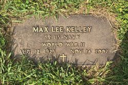


Rev. Max Lee Kelley
| Birth | : | 12 Aug 1925 Blount County, Tennessee, USA |
| Death | : | 14 Nov 2002 Blount County, Tennessee, USA |
| Burial | : | Sacred Heart Cemetery, Monticello, Jones County, USA |
| Coordinate | : | 42.2606010, -91.1905975 |
| Description | : | Reverend Max L. Kelly, age 77 of Alcoa, passed away November 14, 2002. He was born less than two miles away from where he lived most of his life. Jesus came for him while he was cleaning leaves in his yard. He always said that he would rather wear out than rust out. Rev. Kelley was a Sailor on the U.S.S. D.R. Hill during World War II when she was sunk in the Atlantic by a German U-Boat. Many lives were lost when the destroyer went down. He worked at the ALCOA... Read More |
frequently asked questions (FAQ):
-
Where is Rev. Max Lee Kelley's memorial?
Rev. Max Lee Kelley's memorial is located at: Sacred Heart Cemetery, Monticello, Jones County, USA.
-
When did Rev. Max Lee Kelley death?
Rev. Max Lee Kelley death on 14 Nov 2002 in Blount County, Tennessee, USA
-
Where are the coordinates of the Rev. Max Lee Kelley's memorial?
Latitude: 42.2606010
Longitude: -91.1905975
Family Members:
Parent
Spouse
Siblings

Children
Flowers:


Nearby Cemetories:
1. Sacred Heart Cemetery
Monticello, Jones County, USA
Coordinate: 42.2606010, -91.1905975
2. East Monticello Cemetery
East Monticello, Jones County, USA
Coordinate: 42.2597200, -91.1610000
3. Chestnut Street Cemetery
Monticello, Jones County, USA
Coordinate: 42.2382940, -91.1924700
4. Grand Street Cemetery
Monticello, Jones County, USA
Coordinate: 42.2369690, -91.1922590
5. Oakwood Cemetery
Monticello, Jones County, USA
Coordinate: 42.2322006, -91.1761017
6. Bowens Prairie Cemetery
Jones County, USA
Coordinate: 42.2821999, -91.1153030
7. Sand Springs Cemetery
Delaware County, USA
Coordinate: 42.3191986, -91.1706009
8. Saint John's Evangelical Lutheran Cemetery
Monticello, Jones County, USA
Coordinate: 42.2079200, -91.1420500
9. Castle Grove Baptist Cemetery
Jones County, USA
Coordinate: 42.2670100, -91.2936100
10. Livingston Cemetery
Hopkinton, Delaware County, USA
Coordinate: 42.3278008, -91.2438965
11. Langworthy Cemetery
Langworthy, Jones County, USA
Coordinate: 42.1878014, -91.2380981
12. Kiburz Cemetery
Jones County, USA
Coordinate: 42.1758003, -91.1513977
13. Hopkinton Cemetery
Hopkinton, Delaware County, USA
Coordinate: 42.3425000, -91.2405000
14. Zimmerman Cemetery
Jones County, USA
Coordinate: 42.1758003, -91.1496964
15. Immaculate Conception Cemetery
Jones County, USA
Coordinate: 42.2824670, -91.3100540
16. Wayne Zion Cemetery
Jones County, USA
Coordinate: 42.1650009, -91.1825027
17. Prairie Hill Cemetery
Monticello, Jones County, USA
Coordinate: 42.2383003, -91.3193970
18. Grove Creek Cemetery
Delaware County, USA
Coordinate: 42.3013992, -91.3146973
19. Willard Cemetery
York, Delaware County, USA
Coordinate: 42.3641500, -91.2199000
20. Mount Pleasant Cemetery
Hopkinton, Delaware County, USA
Coordinate: 42.3618000, -91.1478000
21. Four Horn Cemetery
Scotch Grove, Jones County, USA
Coordinate: 42.1594009, -91.1307983
22. Zion Reformed Church Cemetery
Cascade, Dubuque County, USA
Coordinate: 42.3465000, -91.0813000
23. Cass Cemetery
Jones County, USA
Coordinate: 42.1684500, -91.3102700
24. Cascade Community Cemetery
Cascade, Dubuque County, USA
Coordinate: 42.2975200, -91.0236200