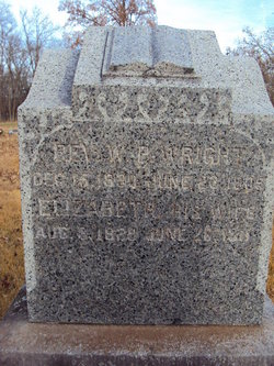
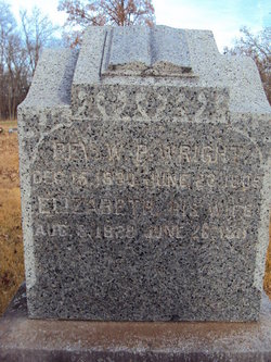
Rev William Parson “Parson Billy” Wright
| Birth | : | 15 Dec 1830 Lincoln County, Missouri, USA |
| Death | : | 23 Jun 1905 St. Clair County, Missouri, USA |
| Burial | : | Mount Pleasant Cemetery, Porterville, Crawford County, USA |
| Coordinate | : | 39.1072006, -87.8244019 |
| Description | : | Rev. William P. Wright, pastor of the Wright Creek Baptist Church, was born in Lincoln County, Missouri December 15, 1830, his parents being William Wright, originally of Washington County, Kentucky, born in 1808, and Ann (Thomas) Wright, also a Kentuckian by birth, born in 1812. They were married in 1830, and have seven children living: William P., Elizabeth P., Morgan, Martin V., Nancy J., Milton F., and Henry F. One son, Thomas J., died in June, 1875. Coming to Missouri the senior Wright settled in Lincoln County in 1830, and after remaining there four years moved to this county (then... Read More |
frequently asked questions (FAQ):
-
Where is Rev William Parson “Parson Billy” Wright's memorial?
Rev William Parson “Parson Billy” Wright's memorial is located at: Mount Pleasant Cemetery, Porterville, Crawford County, USA.
-
When did Rev William Parson “Parson Billy” Wright death?
Rev William Parson “Parson Billy” Wright death on 23 Jun 1905 in St. Clair County, Missouri, USA
-
Where are the coordinates of the Rev William Parson “Parson Billy” Wright's memorial?
Latitude: 39.1072006
Longitude: -87.8244019
Family Members:
Spouse
Children
Flowers:
Nearby Cemetories:
1. Mount Pleasant Cemetery
Porterville, Crawford County, USA
Coordinate: 39.1072006, -87.8244019
2. Faught-Lionberger Cemetery
Dogwood, Crawford County, USA
Coordinate: 39.0897636, -87.8014145
3. Prairie Cemetery
Oblong, Crawford County, USA
Coordinate: 39.0780560, -87.8616670
4. Prairie Grove Cemetery
Licking Township, Crawford County, USA
Coordinate: 39.0780920, -87.8622360
5. Dix Cemetery
Prairie Township, Crawford County, USA
Coordinate: 39.1584760, -87.8359380
6. Grand Prairie Cemetery
Prairie Township, Crawford County, USA
Coordinate: 39.0803000, -87.7420000
7. Cox Cemetery
Crawford County, USA
Coordinate: 39.1693993, -87.7778015
8. Harmony Cemetery
Bellair, Crawford County, USA
Coordinate: 39.1154594, -87.9231949
9. Johnson Cemetery
Licking Township, Crawford County, USA
Coordinate: 39.1636230, -87.8940260
10. Kirk Cemetery
Robinson, Crawford County, USA
Coordinate: 39.0347214, -87.7786102
11. Olive Branch Cemetery
Martinsville, Clark County, USA
Coordinate: 39.1897049, -87.8210877
12. Newlin Cemetery
Robinson, Crawford County, USA
Coordinate: 39.0625000, -87.7311020
13. Randolph Cemetery
Crawford County, USA
Coordinate: 39.0786018, -87.9321976
14. Mount Olive Cemetery
Melrose, Clark County, USA
Coordinate: 39.1743270, -87.7394220
15. Bellair Cemetery
Annapolis, Crawford County, USA
Coordinate: 39.1403160, -87.9389191
16. White Oak Cemetery
Oblong, Crawford County, USA
Coordinate: 39.0683327, -87.9366684
17. Ball Cemetery
Hutsonville, Crawford County, USA
Coordinate: 39.1138992, -87.7016983
18. Guyer Cemetery
Crawford County, USA
Coordinate: 39.1474991, -87.7114029
19. Rains Cemetery
Annapolis, Crawford County, USA
Coordinate: 39.1507301, -87.7099533
20. Wesley Chapel Cemetery
Marshall, Clark County, USA
Coordinate: 39.2072220, -87.8152771
21. Crawford County Poor Farm Cemetery
Robinson, Crawford County, USA
Coordinate: 39.0734420, -87.7017360
22. Davis-Brown Cemetery
Robinson, Crawford County, USA
Coordinate: 39.0324720, -87.7340210
23. Butternut-Willow Creek Cemetery
Moonshine, Clark County, USA
Coordinate: 39.2050400, -87.8888910
24. Plymouth Cemetery
Clark County, USA
Coordinate: 39.1861000, -87.7221985


