


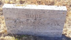
Rhita Marie Bode Hock
| Birth | : | 16 Dec 1923 Elgin, Antelope County, Nebraska, USA |
| Death | : | 21 Mar 2019 Lexington, Dawson County, Nebraska, USA |
| Burial | : | Saint Anns Cemetery, Lexington, Dawson County, USA |
| Coordinate | : | 40.7789001, -99.7114029 |
| Plot | : | DIV. D, LOT 44, SPACE 4. (CREMATION) |
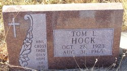
| Description | : | Rhita M. Hock, 95, of Lexington, Nebraska died on Thursday, March 21, 2019 at Plum Creek Care Center in Lexington. Rhita was born December 16, 1923 in Elgin, Nebraska to Charles K. and Ida (Jouchum) Bode. At the age of 8, her family moved to Sutherland, Nebraska where she graduated with the class of 1942. Following graduation Rhita moved to Lexington where she was the bookkeeper at Banks Clothing and met the love of her life, Thomas. She was united in marriage to Tom Hock on February 6, 1944 in Kansas. To this union, nine children were born, Larry,... Read More |
frequently asked questions (FAQ):
-
Where is Rhita Marie Bode Hock's memorial?
Rhita Marie Bode Hock's memorial is located at: Saint Anns Cemetery, Lexington, Dawson County, USA.
-
When did Rhita Marie Bode Hock death?
Rhita Marie Bode Hock death on 21 Mar 2019 in Lexington, Dawson County, Nebraska, USA
-
Where are the coordinates of the Rhita Marie Bode Hock's memorial?
Latitude: 40.7789001
Longitude: -99.7114029
Family Members:
Parent

Spouse
Siblings

Flowers:


Nearby Cemetories:
1. Greenwood Cemetery
Lexington, Dawson County, USA
Coordinate: 40.7956467, -99.7286682
2. First United Methodist Church Columbarium
Lexington, Dawson County, USA
Coordinate: 40.7810000, -99.7397000
3. Evergreen Cemetery
Lexington, Dawson County, USA
Coordinate: 40.7639008, -99.6791992
4. Mount Hope Cemetery
Dawson County, USA
Coordinate: 40.8293991, -99.6733017
5. Hewitt Cemetery
Lexington, Dawson County, USA
Coordinate: 40.8588982, -99.7769012
6. Robb Cemetery
Smithfield, Gosper County, USA
Coordinate: 40.6710691, -99.6996001
7. Buffalo Grove Presbyterian Church Cemetery
Buffalo, Dawson County, USA
Coordinate: 40.8721000, -99.8270000
8. Hillside Cemetery
Dawson County, USA
Coordinate: 40.8946991, -99.7869034
9. Plum Creek Massacre Cemetery
Phelps County, USA
Coordinate: 40.6726840, -99.6058220
10. Grace Cemetery
Cozad, Dawson County, USA
Coordinate: 40.8602982, -99.8644028
11. Overton Cemetery
Overton, Dawson County, USA
Coordinate: 40.7317009, -99.5222015
12. Saint Johns Lutheran Cemetery
Lexington, Dawson County, USA
Coordinate: 40.9019012, -99.8458023
13. Quakerville Cemetery
Gosper County, USA
Coordinate: 40.6189003, -99.8097000
14. Adullam Cemetery
Bertrand, Phelps County, USA
Coordinate: 40.6265000, -99.5856000
15. Cozad Cemetery
Cozad, Dawson County, USA
Coordinate: 40.8605995, -99.9475021
16. Elwood Cemetery
Elwood, Gosper County, USA
Coordinate: 40.5999300, -99.8397300
17. Platte Valley Cemetery
Phelps County, USA
Coordinate: 40.6425018, -99.5028000
18. Keely Cemetery
Smithfield, Gosper County, USA
Coordinate: 40.5727500, -99.6563500
19. Saint Patricks Cemetery
Eddyville, Dawson County, USA
Coordinate: 40.9747009, -99.6093979
20. Sandstrom Cemetery
Phelps County, USA
Coordinate: 40.5983009, -99.5661011
21. Jewell Cemetery
Sumner, Dawson County, USA
Coordinate: 40.9599991, -99.5646973
22. Hope Lutheran Cemetery
Smithfield, Gosper County, USA
Coordinate: 40.5667500, -99.6800000
23. Fairview Cemetery
Dawson County, USA
Coordinate: 40.7719002, -99.9955978
24. Cottonwood Cemetery
Dawson County, USA
Coordinate: 40.9322014, -99.9197006