
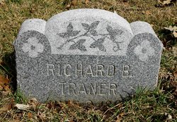
Richard B “Dick” Traner
| Birth | : | 2 Jun 1854 Wisconsin, USA |
| Death | : | 14 Apr 1908 Atkinson, Holt County, Nebraska, USA |
| Burial | : | Carroll City Cemetery, Carroll, Carroll County, USA |
| Coordinate | : | 42.0560963, -94.8599856 |
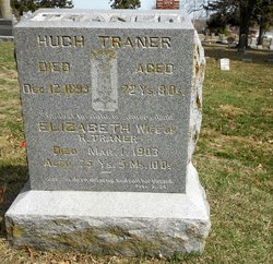
| Description | : | Richard was the son of Hugh Traner and Elizabeth Brown. He married Ellen Walrod Young on 29 Mar 1880 in Carroll, Iowa. They were the parents of Roy. April 16, 1908 - Carroll Times - The news of the death Tuesday at Atkinson, Neb., of Richard Traner, formerly a resident of this city and of Lake View, reached friends of the family that evening. The remains were brought here yesterday afternoon by way of Sioux City. The local lodge of Odd Fellows, of which order deceased was a member, took the remains in charge and conducted the obsequies at... Read More |
frequently asked questions (FAQ):
-
Where is Richard B “Dick” Traner's memorial?
Richard B “Dick” Traner's memorial is located at: Carroll City Cemetery, Carroll, Carroll County, USA.
-
When did Richard B “Dick” Traner death?
Richard B “Dick” Traner death on 14 Apr 1908 in Atkinson, Holt County, Nebraska, USA
-
Where are the coordinates of the Richard B “Dick” Traner's memorial?
Latitude: 42.0560963
Longitude: -94.8599856
Family Members:
Parent

Spouse

Siblings
Flowers:


Nearby Cemetories:
1. Carroll City Cemetery
Carroll, Carroll County, USA
Coordinate: 42.0560963, -94.8599856
2. Mount Olivet Cemetery
Carroll, Carroll County, USA
Coordinate: 42.0536340, -94.8595510
3. Holy Angels Cemetery
Carroll County, USA
Coordinate: 42.0014000, -94.9141998
4. Saint Francis Cemetery
Maple River, Carroll County, USA
Coordinate: 42.0969009, -94.9372025
5. Saint Marys Catholic Cemetery
Willey, Carroll County, USA
Coordinate: 41.9783363, -94.8212204
6. Holy Family Cemetery
Lidderdale, Carroll County, USA
Coordinate: 42.1178017, -94.7839966
7. West Lawn Cemetery
Glidden, Carroll County, USA
Coordinate: 42.0649986, -94.7406006
8. Immanuel Cemetery
Lidderdale, Carroll County, USA
Coordinate: 42.1389008, -94.8022003
9. Saint Augustine Cemetery
Halbur, Carroll County, USA
Coordinate: 42.0066986, -94.9744034
10. Our Lady Of Mount Carmel Cemetery
Mount Carmel, Carroll County, USA
Coordinate: 42.1547012, -94.9088974
11. Arcadia Cemetery
Arcadia Township, Carroll County, USA
Coordinate: 42.1000680, -95.0130550
12. East Liberty Cemetery
Lidderdale, Carroll County, USA
Coordinate: 42.1591988, -94.7636032
13. Saint Johns Catholic Cemetery
Arcadia, Carroll County, USA
Coordinate: 42.0855406, -95.0341577
14. Dickson Cemetery
Glidden Township, Carroll County, USA
Coordinate: 42.1074982, -94.6939011
15. McCurdy Cemetery
Carroll County, USA
Coordinate: 41.9403000, -94.7649994
16. Saint Bernards Cemetery
Breda, Carroll County, USA
Coordinate: 42.1786003, -94.9732971
17. Elba Cemetery
Templeton, Carroll County, USA
Coordinate: 41.9068985, -94.9131012
18. Sacred Heart Cemetery
Templeton, Carroll County, USA
Coordinate: 41.9138746, -94.9460994
19. North Coon Cemetery
Carroll County, USA
Coordinate: 42.1260986, -94.6716995
20. Dedham Cemetery
Dedham, Carroll County, USA
Coordinate: 41.8993988, -94.8225021
21. Saint Josephs Cemetery
Dedham, Carroll County, USA
Coordinate: 41.8993988, -94.8210983
22. Old Carrollton Cemetery
Carrollton, Carroll County, USA
Coordinate: 41.9233017, -94.7403030
23. Lanesboro Cemetery
Lanesboro, Carroll County, USA
Coordinate: 42.1810989, -94.7230988
24. Luckow Cemetery
Auburn, Sac County, USA
Coordinate: 42.2168999, -94.9266968