
| Birth | : | 28 Feb 1926 Lidderdale, Carroll County, Iowa, USA |
| Death | : | 2 May 2016 Omaha, Douglas County, Nebraska, USA |
| Burial | : | East Liberty Cemetery, Lidderdale, Carroll County, USA |
| Coordinate | : | 42.1591988, -94.7636032 |
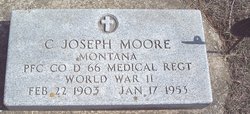
| Description | : | Dick was born to Geraldine(Gotsch) and Chester (Joe)Moore He attended Lidderdale public school. On March 23-1943 he enlisted in the United States Navy. He was assigned as a gunner on the destroyer, USS Brown, serving in the South Asiatic-Pacific Theater during World War II. In 1947 he enlisted in the Army as a MP Stationed at Fort Sheridan, IL. He married Colleen Grace Schleisman September 3-1949. To this union 4 children were born. Dick received his high school diploma from Fort Dodge Community College. He worked for the ASCS USDA in Carroll, IA for 14 years. In 1967 he too a... Read More |
frequently asked questions (FAQ):
-
Where is Richard Charles “Dick” Moore's memorial?
Richard Charles “Dick” Moore's memorial is located at: East Liberty Cemetery, Lidderdale, Carroll County, USA.
-
When did Richard Charles “Dick” Moore death?
Richard Charles “Dick” Moore death on 2 May 2016 in Omaha, Douglas County, Nebraska, USA
-
Where are the coordinates of the Richard Charles “Dick” Moore's memorial?
Latitude: 42.1591988
Longitude: -94.7636032
Family Members:
Parent
Siblings


Nearby Cemetories:
1. East Liberty Cemetery
Lidderdale, Carroll County, USA
Coordinate: 42.1591988, -94.7636032
2. Immanuel Cemetery
Lidderdale, Carroll County, USA
Coordinate: 42.1389008, -94.8022003
3. Lanesboro Cemetery
Lanesboro, Carroll County, USA
Coordinate: 42.1810989, -94.7230988
4. Holy Family Cemetery
Lidderdale, Carroll County, USA
Coordinate: 42.1178017, -94.7839966
5. Dickson Cemetery
Glidden Township, Carroll County, USA
Coordinate: 42.1074982, -94.6939011
6. North Coon Cemetery
Carroll County, USA
Coordinate: 42.1260986, -94.6716995
7. Cottonwood Cemetery
Lake City, Calhoun County, USA
Coordinate: 42.2491989, -94.7936020
8. West Lawn Cemetery
Glidden, Carroll County, USA
Coordinate: 42.0649986, -94.7406006
9. Our Lady Of Mount Carmel Cemetery
Mount Carmel, Carroll County, USA
Coordinate: 42.1547012, -94.9088974
10. Bishop Cemetery
Calhoun Township, Calhoun County, USA
Coordinate: 42.2230400, -94.6453190
11. Lake City Cemetery
Lake City, Calhoun County, USA
Coordinate: 42.2719002, -94.7574997
12. Saint Marys Catholic Cemetery
Lake City, Calhoun County, USA
Coordinate: 42.2730000, -94.7567000
13. Carroll City Cemetery
Carroll, Carroll County, USA
Coordinate: 42.0560963, -94.8599856
14. Mount Olivet Cemetery
Carroll, Carroll County, USA
Coordinate: 42.0536340, -94.8595510
15. Luckow Cemetery
Auburn, Sac County, USA
Coordinate: 42.2168999, -94.9266968
16. Saint Marys Cemetery
Sac County, USA
Coordinate: 42.2611008, -94.8839035
17. Oak Lawn Cemetery
Auburn, Sac County, USA
Coordinate: 42.2611008, -94.8852997
18. Dillavou Cemetery
Kendrick Township, Greene County, USA
Coordinate: 42.0802994, -94.6138992
19. Saint Francis Cemetery
Maple River, Carroll County, USA
Coordinate: 42.0969009, -94.9372025
20. Grant City Cemetery
Grant City, Sac County, USA
Coordinate: 42.2681007, -94.8908005
21. Saint Bernards Cemetery
Breda, Carroll County, USA
Coordinate: 42.1786003, -94.9732971
22. Saint Patricks Cemetery
Churdan, Greene County, USA
Coordinate: 42.1605988, -94.5511017
23. Old Cedar Cemetery
Adaza, Greene County, USA
Coordinate: 42.1874821, -94.5419194
24. Saint Marys Catholic Cemetery
Willey, Carroll County, USA
Coordinate: 41.9783363, -94.8212204