

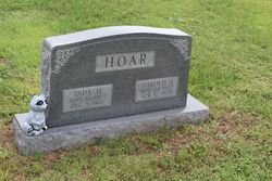
Richard Gail Hoar
| Birth | : | 1 Sep 1927 Kansas, USA |
| Death | : | 16 May 2020 |
| Burial | : | Woodston Cemetery, Woodston, Rooks County, USA |
| Coordinate | : | 39.4375000, -99.1268997 |
| Description | : | Richard Gail Hoar was born on September 1, 1927 to Harold H. and Inda (Merriman) Hoar in Lowell Township, Woodston, KS. He grew up on the family farm south & west of Woodston. He attended country school, 3miles by country road, but learned it was much quicker by crossing the river & cutting across the field and pastures. After graduating from Woodston Rural High School in 1945, Gail joined the Navy and served as a cook on the USS Shakle Ship at San Diego, California. He returned home to Woodston from the service in 1946 and began working. |
frequently asked questions (FAQ):
-
Where is Richard Gail Hoar's memorial?
Richard Gail Hoar's memorial is located at: Woodston Cemetery, Woodston, Rooks County, USA.
-
When did Richard Gail Hoar death?
Richard Gail Hoar death on 16 May 2020 in
-
Where are the coordinates of the Richard Gail Hoar's memorial?
Latitude: 39.4375000
Longitude: -99.1268997
Family Members:
Parent

Spouse

Siblings
Flowers:


Nearby Cemetories:
1. Woodston Cemetery
Woodston, Rooks County, USA
Coordinate: 39.4375000, -99.1268997
2. Survey Cemetery
Woodston, Rooks County, USA
Coordinate: 39.3722000, -99.1333008
3. Spring Branch Cemetery
Woodston, Rooks County, USA
Coordinate: 39.5099983, -99.0580978
4. West Hope Cemetery
Rooks County, USA
Coordinate: 39.5024986, -99.2110977
5. Ash Rock Cemetery
Woodston, Rooks County, USA
Coordinate: 39.5248909, -99.0817719
6. Pleasant Valley Cemetery
Osborne County, USA
Coordinate: 39.4583015, -99.0077972
7. Johnson Cemetery
Stockton, Rooks County, USA
Coordinate: 39.3493996, -99.1941986
8. Stockton Cemetery
Stockton, Rooks County, USA
Coordinate: 39.4406700, -99.2647400
9. Saint Thomas Cemetery
Stockton, Rooks County, USA
Coordinate: 39.4449997, -99.2771988
10. Chalk Mound Cemetery
Laton, Rooks County, USA
Coordinate: 39.3208008, -99.0852966
11. Pleasant Plain Cemetery
Osborne County, USA
Coordinate: 39.3367004, -99.0372009
12. Pioneer Cemetery
Alton, Osborne County, USA
Coordinate: 39.4742012, -98.9749985
13. Mount Ayr Cemetery
Alton, Osborne County, USA
Coordinate: 39.3764000, -98.9717026
14. Old Stockton Cemetery
Stockton, Rooks County, USA
Coordinate: 39.4597015, -99.3050003
15. Bigge Family Cemetery
Stockton, Rooks County, USA
Coordinate: 39.4584700, -99.3053200
16. Grant Center Cemetery
Alton, Osborne County, USA
Coordinate: 39.5242004, -98.9708023
17. Sumner Cemetery
Alton, Osborne County, USA
Coordinate: 39.4799995, -98.9338913
18. Pleasant Ridge Cemetery
Kirwin, Phillips County, USA
Coordinate: 39.5963000, -99.1234000
19. Aurora Cemetery
Laton, Rooks County, USA
Coordinate: 39.2778015, -99.0847015
20. Greenwood Cemetery
Kirwin, Phillips County, USA
Coordinate: 39.5931900, -99.2064600
21. Bow Creek Cemetery
Glade, Phillips County, USA
Coordinate: 39.5681000, -99.2696991
22. Twin Mound Cemetery
Rooks County, USA
Coordinate: 39.2855988, -99.2319031
23. Kill Creek Cemetery
Alton, Osborne County, USA
Coordinate: 39.3805528, -98.8967658
24. Leasburg Cemetery
Cedar, Smith County, USA
Coordinate: 39.5819016, -98.9728012