
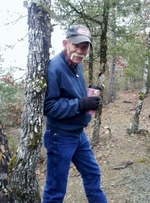
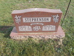
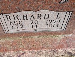
Richard Lee Stephenson
| Birth | : | 20 Aug 1954 Clarence, Shelby County, Missouri, USA |
| Death | : | 14 Apr 2014 Tulsa, Tulsa County, Oklahoma, USA |
| Burial | : | Maplewood Cemetery, Clarence, Shelby County, USA |
| Coordinate | : | 39.7508011, -92.2572021 |
| Description | : | Richard Lee Stephenson, 59, city of Broken Arrow truck driver, died Monday. Service 2 p.m. Thursday, Sunnyside Baptist Church, and graveside service 10 a.m. Saturday, Maple Wood Cemetery, Clarence, Mo. Wright-Brown, Coweta. -------------- Richard Lee Stephenson, age 59, of Broken Arrow, OK was born at home in Clarence, Missouri to Juanita (Saunders) Stephenson Cockrum and Richard Glenn Stephenson on August 20, 1954. He married Deborah Kay Copenhaver on May 12, 1973. Together they raised two wonderful sons. Richard went to Heaven to be with his Lord and Savior on Monday, April 14th, 2014 at 1:55 in the afternoon at St. Francis Heart... Read More |
frequently asked questions (FAQ):
-
Where is Richard Lee Stephenson's memorial?
Richard Lee Stephenson's memorial is located at: Maplewood Cemetery, Clarence, Shelby County, USA.
-
When did Richard Lee Stephenson death?
Richard Lee Stephenson death on 14 Apr 2014 in Tulsa, Tulsa County, Oklahoma, USA
-
Where are the coordinates of the Richard Lee Stephenson's memorial?
Latitude: 39.7508011
Longitude: -92.2572021
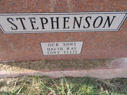
Family Members:
Parent
Spouse

Siblings


Nearby Cemetories:
1. Maplewood Cemetery
Clarence, Shelby County, USA
Coordinate: 39.7508011, -92.2572021
2. Clarence City Cemetery
Clarence, Shelby County, USA
Coordinate: 39.7493750, -92.2624800
3. Saint Patricks Cemetery
Clarence, Shelby County, USA
Coordinate: 39.7352982, -92.2714005
4. Hopper Cemetery
Shelby County, USA
Coordinate: 39.8083000, -92.2683029
5. Amish Cemetery
Macon County, USA
Coordinate: 39.7858009, -92.3208008
6. Hawkins Cemetery
Shelby County, USA
Coordinate: 39.8111000, -92.2874985
7. Bethel Christian Church Cemetery
Anabel, Macon County, USA
Coordinate: 39.8018200, -92.3252200
8. Patton Cemetery
Hagers Grove, Shelby County, USA
Coordinate: 39.8155700, -92.2022800
9. Ebenezer Cemetery
Hagers Grove, Shelby County, USA
Coordinate: 39.8302994, -92.2652969
10. Walker Cemetery
Macon County, USA
Coordinate: 39.6823640, -92.3117360
11. Winn Family Cemetery
Macon County, USA
Coordinate: 39.7589684, -92.3646774
12. Hagers Grove Cemetery
Hagers Grove, Shelby County, USA
Coordinate: 39.8305000, -92.2236000
13. Ewing Cemetery
Macon County, USA
Coordinate: 39.7616997, -92.3688965
14. Union Grove Cemetery
Clarence, Shelby County, USA
Coordinate: 39.6630360, -92.2602920
15. Ten Mile Baptist Church Cemetery
Ten Mile, Macon County, USA
Coordinate: 39.8082120, -92.3440980
16. Bethlehem Cemetery
Macon, Macon County, USA
Coordinate: 39.7070007, -92.3570023
17. Brown Cemetery
Macon County, USA
Coordinate: 39.7499140, -92.3723280
18. Sage Cemetery
Macon County, USA
Coordinate: 39.6738570, -92.3175640
19. Graves Chapel Cemetery
Anabel, Macon County, USA
Coordinate: 39.6815900, -92.3337200
20. Bacon Chapel Cemetery
Shelbyville, Shelby County, USA
Coordinate: 39.7511487, -92.1368436
21. Morris Cemetery
Shelby County, USA
Coordinate: 39.8227997, -92.1808014
22. Mount Hope Cemetery
Shelby County, USA
Coordinate: 39.7930984, -92.1442032
23. Harris Graveyard
Woodville, Macon County, USA
Coordinate: 39.6863850, -92.3543810
24. Mitts Cemetery
Macon County, USA
Coordinate: 39.8466988, -92.2913971