
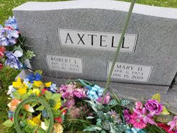
Robert “Bob” Axtell
| Birth | : | 24 Jan 1926 Davis County, Iowa, USA |
| Death | : | 16 Jan 2007 Des Moines, Polk County, Iowa, USA |
| Burial | : | Drakesville Cemetery, Drakesville, Davis County, USA |
| Coordinate | : | 40.7947006, -92.4852982 |
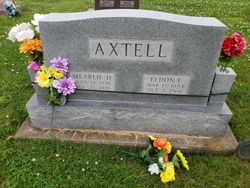
| Description | : | DRAKESVILLE. ROBERT “BOB” AXTELL, age 80 of Ottumwa and former Drakesville resident died January 16, 2007 at Iowa Methodist Medical Center in Des Moines. He was born January 24, 1926 in Davis County, Iowa to Eldon and Mearlie Cayton Axtell. He married Mary Baird April 29, 1951 in Nashua, Iowa. He served in the United States Army. He had been a resident of Davis and Wapello counties his lifetime and was a farmer. He was a member of the National Farmers Organization. He is survived by his wife; 2 sons Phill (Cindy) Axtell of... Read More |
frequently asked questions (FAQ):
-
Where is Robert “Bob” Axtell's memorial?
Robert “Bob” Axtell's memorial is located at: Drakesville Cemetery, Drakesville, Davis County, USA.
-
When did Robert “Bob” Axtell death?
Robert “Bob” Axtell death on 16 Jan 2007 in Des Moines, Polk County, Iowa, USA
-
Where are the coordinates of the Robert “Bob” Axtell's memorial?
Latitude: 40.7947006
Longitude: -92.4852982
Family Members:
Parent

Spouse


Nearby Cemetories:
1. Drakesville Cemetery
Drakesville, Davis County, USA
Coordinate: 40.7947006, -92.4852982
2. McConnell Cemetery
Drakesville, Davis County, USA
Coordinate: 40.8044440, -92.5294440
3. Breeding Cemetery
Drakesville, Davis County, USA
Coordinate: 40.8302994, -92.4950027
4. Cammack Cemetery
Drakesville, Davis County, USA
Coordinate: 40.7611008, -92.4664001
5. Lester Cemetery
Drakesville, Davis County, USA
Coordinate: 40.7835999, -92.4336014
6. Pleasant Valley Cemetery
Davis County, USA
Coordinate: 40.7510000, -92.4879000
7. Harbour Cemetery
Davis County, USA
Coordinate: 40.8314018, -92.4419022
8. Hammans Cemetery
Davis County, USA
Coordinate: 40.8059998, -92.5530014
9. Runkles Cemetery
West Grove, Davis County, USA
Coordinate: 40.7602997, -92.5496979
10. Apostolic Christian Cemetery
Bloomfield, Davis County, USA
Coordinate: 40.7623740, -92.4168850
11. West Union Cemetery
Bloomfield, Davis County, USA
Coordinate: 40.7916850, -92.5668560
12. Bloomfield IOOF Cemetery
Bloomfield, Davis County, USA
Coordinate: 40.7621080, -92.4124770
13. Pollard Cemetery
Davis County, USA
Coordinate: 40.7275009, -92.4682999
14. Kingdom Cemetery
Davis County, USA
Coordinate: 40.8428001, -92.4194031
15. Wheeler Cemetery
Davis County, USA
Coordinate: 40.8530000, -92.5378000
16. Atwood Cemetery
West Grove, Davis County, USA
Coordinate: 40.7669400, -92.5722300
17. Adams Cemetery
Marion Township, Davis County, USA
Coordinate: 40.8280890, -92.5776570
18. Wesley Chapel Cemetery
Ash Grove, Davis County, USA
Coordinate: 40.8643990, -92.5330963
19. Baer Cemetery
Davis County, USA
Coordinate: 40.8709984, -92.5100021
20. Bloomfield South Cemetery
Bloomfield, Davis County, USA
Coordinate: 40.7402992, -92.4075012
21. Stufflebeam Cemetery
Drakesville, Davis County, USA
Coordinate: 40.7894440, -92.5969440
22. Dunnville Cemetery
Floris, Davis County, USA
Coordinate: 40.8227997, -92.3796997
23. West Grove Cemetery
West Grove, Davis County, USA
Coordinate: 40.7289009, -92.5567017
24. Glassburner Cemetery
Davis County, USA
Coordinate: 40.8335991, -92.5856018