
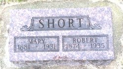
Robert Burns Short
| Birth | : | 25 May 1874 Greenwood County, Kansas, USA |
| Death | : | 12 Mar 1936 Carroll County, Iowa, USA |
| Burial | : | Dillavou Cemetery, Kendrick Township, Greene County, USA |
| Coordinate | : | 42.0802994, -94.6138992 |
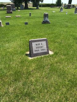
| Description | : | Notes for ROBERT BURNS SHORT:. R. B. Short Died Of Heart Disease --. Was at Work on Sewer Ditch at the Time on Wednesday . Robert B. Short 68, one of our well-known long time residents, fell dead Wednesday at 10:30 while at work on a sewer ditch at the home of Mrs. Marie Snyder, in northeast Glidden.. He had been in his usual health and his death was entirely unexpected. With his son Ray, he had made an excavation at the Snyder place and at work in the bottom of the ditch when, as told by his son, he... Read More |
frequently asked questions (FAQ):
-
Where is Robert Burns Short's memorial?
Robert Burns Short's memorial is located at: Dillavou Cemetery, Kendrick Township, Greene County, USA.
-
When did Robert Burns Short death?
Robert Burns Short death on 12 Mar 1936 in Carroll County, Iowa, USA
-
Where are the coordinates of the Robert Burns Short's memorial?
Latitude: 42.0802994
Longitude: -94.6138992
Family Members:
Parent
Spouse

Siblings
Children

Flowers:


Nearby Cemetories:
1. Dillavou Cemetery
Kendrick Township, Greene County, USA
Coordinate: 42.0802994, -94.6138992
2. Scranton Township Cemetery
Scranton, Greene County, USA
Coordinate: 42.0306015, -94.5783005
3. North Coon Cemetery
Carroll County, USA
Coordinate: 42.1260986, -94.6716995
4. Dickson Cemetery
Glidden Township, Carroll County, USA
Coordinate: 42.1074982, -94.6939011
5. Saint Patricks Cemetery
Churdan, Greene County, USA
Coordinate: 42.1605988, -94.5511017
6. Gibson-Fleck-Thompson Cemetery
Scranton, Greene County, USA
Coordinate: 42.0428870, -94.4988800
7. West Lawn Cemetery
Glidden, Carroll County, USA
Coordinate: 42.0649986, -94.7406006
8. Old Cedar Cemetery
Adaza, Greene County, USA
Coordinate: 42.1874821, -94.5419194
9. Highland Township Cemetery
Churdan, Greene County, USA
Coordinate: 42.1518310, -94.4699120
10. Lanesboro Cemetery
Lanesboro, Carroll County, USA
Coordinate: 42.1810989, -94.7230988
11. Holy Family Cemetery
Lidderdale, Carroll County, USA
Coordinate: 42.1178017, -94.7839966
12. Fair Oaks Cemetery
Scranton, Greene County, USA
Coordinate: 42.0355988, -94.4460983
13. Wright Cemetery
Jefferson, Greene County, USA
Coordinate: 42.0228004, -94.4477997
14. East Liberty Cemetery
Lidderdale, Carroll County, USA
Coordinate: 42.1591988, -94.7636032
15. Bishop Cemetery
Calhoun Township, Calhoun County, USA
Coordinate: 42.2230400, -94.6453190
16. Immanuel Cemetery
Lidderdale, Carroll County, USA
Coordinate: 42.1389008, -94.8022003
17. Headley Cemetery
Jefferson, Greene County, USA
Coordinate: 42.0041504, -94.4335815
18. Willow Cemetery
Greene County, USA
Coordinate: 41.9067001, -94.5730972
19. McCurdy Cemetery
Carroll County, USA
Coordinate: 41.9403000, -94.7649994
20. Saint Joseph Cemetery
Jefferson, Greene County, USA
Coordinate: 42.0289001, -94.3818970
21. Evergreen Cemetery
Lohrville, Calhoun County, USA
Coordinate: 42.2505989, -94.5330963
22. Old Carrollton Cemetery
Carrollton, Carroll County, USA
Coordinate: 41.9233017, -94.7403030
23. Carroll City Cemetery
Carroll, Carroll County, USA
Coordinate: 42.0560963, -94.8599856
24. Mount Olivet Cemetery
Carroll, Carroll County, USA
Coordinate: 42.0536340, -94.8595510