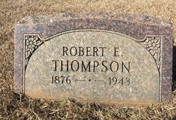
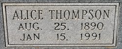
Robert E Thompson
| Birth | : | 1876 |
| Death | : | 1943 |
| Burial | : | Norton Summit Cemetery, Norton Summit, Adelaide Hills Council, Australia |
| Coordinate | : | -34.9273630, 138.7311780 |
| Description | : | Sabine Index, Many, La., Apr 23, 1943 23 Apr 1943 - Funeral rites for R. E. Thompson, age 67 years, were held Monday at Prospect church. Rev. C. W. Williams of Many and Rev. Henry Chance of Hornbeck officiated. Interment in Prospect cemetery, Dennis-Green funeral home in charge. Surviving are father, E. P. Thompson, Gandy; four brothers, Trudeaux of Baton Rouge, Levy of Waterproof, John of Houma and Alcide of New Orleans; three sisters, Mrs. H. H. Simmons of Monroe, Mrs. L. L. Sandel of Gandy and Mrs. Virginia Conerly of Logansport. |
frequently asked questions (FAQ):
-
Where is Robert E Thompson's memorial?
Robert E Thompson's memorial is located at: Norton Summit Cemetery, Norton Summit, Adelaide Hills Council, Australia.
-
When did Robert E Thompson death?
Robert E Thompson death on 1943 in
-
Where are the coordinates of the Robert E Thompson's memorial?
Latitude: -34.9273630
Longitude: 138.7311780
Family Members:
Parent
Siblings
Nearby Cemetories:
1. Grassy Flat Cemetery
Norton Summit, Adelaide Hills Council, Australia
Coordinate: -34.9225490, 138.7271780
2. Summertown Cemetery
Summertown, Adelaide Hills Council, Australia
Coordinate: -34.9584300, 138.7366600
3. Montacute Cemetery
Montacute, Adelaide Hills Council, Australia
Coordinate: -34.8911600, 138.7505000
4. Mt. Lofty Cemetery
Uraidla, Adelaide Hills Council, Australia
Coordinate: -34.9710900, 138.7389300
5. Magill General Cemetery
Magill, Campbelltown City, Australia
Coordinate: -34.9163970, 138.6744980
6. Saint George's Cemetery
Magill, Campbelltown City, Australia
Coordinate: -34.9070310, 138.6763380
7. St David's Anglican Church
Burnside City, Australia
Coordinate: -34.9356740, 138.6601381
8. Athelstone Independent Cemetery
Athelstone, Campbelltown City, Australia
Coordinate: -34.8744850, 138.6956870
9. Athelstone Gorge Primitive Methodist Cemetery
Athelstone, Campbelltown City, Australia
Coordinate: -34.8646690, 138.7133650
10. Kensington Norwood Pioneers Park
Kensington, Norwood Payneham St Peters City, Australia
Coordinate: -34.9248780, 138.6461020
11. St. Matthew's Anglican Church Cemetery
Marryatville, Norwood Payneham St Peters City, Australia
Coordinate: -34.9274120, 138.6443630
12. Clayton-Wesley Uniting Church Cemetery
Kensington, Norwood Payneham St Peters City, Australia
Coordinate: -34.9204920, 138.6416820
13. St. Martin's Anglican Church Cemetery
Campbelltown, Campbelltown City, Australia
Coordinate: -34.8762440, 138.6662340
14. Payneham Cemetery
Payneham, Norwood Payneham St Peters City, Australia
Coordinate: -34.9025719, 138.6443172
15. St. Saviour's Cemetery
Glen Osmond, Burnside City, Australia
Coordinate: -34.9615400, 138.6457300
16. Monastery Memorial Garden
Urrbrae, Mitcham City, Australia
Coordinate: -34.9639340, 138.6409670
17. Klemzig Pioneer Memorial Garden
Klemzig, Port Adelaide Enfield City, Australia
Coordinate: -34.8832580, 138.6432830
18. Bridgewater Methodist Cemetery
Bridgewater, Adelaide Hills Council, Australia
Coordinate: -35.0091800, 138.7641800
19. Hope Valley Cemetery
Hope Valley, Tea Tree Gully City, Australia
Coordinate: -34.8441550, 138.6954700
20. Bonney Flat Methodist Cemetery
Balhannah, Adelaide Hills Council, Australia
Coordinate: -34.9887520, 138.8157610
21. Stirling District Cemetery
Stirling, Adelaide Hills Council, Australia
Coordinate: -35.0204710, 138.7512770
22. St. Thomas Anglican Church Cemetery
Balhannah, Adelaide Hills Council, Australia
Coordinate: -34.9910900, 138.8260410
23. Walkerville Wesleyan Cemetery
Walkerville, Australia
Coordinate: -34.8921000, 138.6130500
24. Houghton Cemetery
Houghton, Adelaide Hills Council, Australia
Coordinate: -34.8280580, 138.7680070


