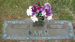
| Birth | : | 13 Feb 1892 Leesburg, Loudoun County, Virginia, USA |
| Death | : | 4 Nov 1962 |
| Burial | : | Lone Tree Cemetery, Lone Tree, Johnson County, USA |
| Coordinate | : | 41.4922900, -91.4254330 |
| Inscription | : | ROBERT E. SR. / FEB. 13, 1892 / NOV. 4, 1962 / HARRIET A. / APR. 26, 1894 / MAY 12, 1969 |
| Description | : | Son of George W. and Lorena Darr. Robert Earl Darr married Harriet Alice Williams in Washington, D. C., on 21 September 1918. |
frequently asked questions (FAQ):
-
Where is Robert Earl Darr Sr.'s memorial?
Robert Earl Darr Sr.'s memorial is located at: Lone Tree Cemetery, Lone Tree, Johnson County, USA.
-
When did Robert Earl Darr Sr. death?
Robert Earl Darr Sr. death on 4 Nov 1962 in
-
Where are the coordinates of the Robert Earl Darr Sr.'s memorial?
Latitude: 41.4922900
Longitude: -91.4254330
Family Members:
Parent
Spouse
Siblings
Children
Flowers:
Left by Anonymous on 04 May 2011
about 50 years ago you wrote in my autograph book. Roses are red, violets are blue,There is no girl, as sweet as youI love and miss you Granddad
Left by Anonymous on 20 Jun 2011
So many memories... the cherry tree you had us kids climb and throw down cherries to you. The old chicken house where you'd roast peanuts on the wood stove for us kids. I love you Granddad and always will.
Left by Anonymous on 18 Mar 2012
Hi Granddad,You never met your youngest grandson Robbie. Over the years I've tried to tell him all about you. All about the big beautiful garden you had every year, and the push mower you'd cut all the grass with, the peanuts you'd roast us kids, just everything I can remember. Hopefully through this he'll understand what an honest, sweet, loving person we had as a grandfather. Read less
Left by Anonymous on 14 Sep 2012
Left by Anonymous on 20 Aug 2014

1st cousin 2x removed
Left by Anonymous on 26 Mar 2021
Nearby Cemetories:
1. Lone Tree Cemetery
Lone Tree, Johnson County, USA
Coordinate: 41.4922900, -91.4254330
2. Evans Cemetery
Johnson County, USA
Coordinate: 41.4688988, -91.4741974
3. Fountain Cemetery
Johnson County, USA
Coordinate: 41.5200005, -91.4728012
4. Lenz Cemetery
Nichols, Muscatine County, USA
Coordinate: 41.5101370, -91.3631260
5. River Junction Cemetery
Lone Tree, Johnson County, USA
Coordinate: 41.4914856, -91.4958267
6. Walker Cemetery
Johnson County, USA
Coordinate: 41.5186005, -91.4903030
7. Saint Marys Cemetery
Nichols, Muscatine County, USA
Coordinate: 41.4843000, -91.3480000
8. Trowbridge-Lenz Cemetery
Lone Tree, Johnson County, USA
Coordinate: 41.5523490, -91.4587780
9. Swank Cemetery
Johnson County, USA
Coordinate: 41.4273911, -91.4497299
10. Clark Cemetery
Iowa Township, Washington County, USA
Coordinate: 41.4305769, -91.4918283
11. Grave Yard Point Cemetery
Riverside, Washington County, USA
Coordinate: 41.4272436, -91.4862725
12. Cline Cemetery
Johnson County, USA
Coordinate: 41.5182100, -91.5336350
13. Sandtown Cemetery
Hills, Johnson County, USA
Coordinate: 41.5544014, -91.5068970
14. Clarke Cemetery
Union Township, Louisa County, USA
Coordinate: 41.4155998, -91.4824982
15. Forbes Cemetery
Louisa County, USA
Coordinate: 41.4000230, -91.4140480
16. Knight Cemetery
Oakland Township, Louisa County, USA
Coordinate: 41.4041886, -91.4668272
17. South Prairie Cemetery
West Liberty, Muscatine County, USA
Coordinate: 41.5541992, -91.3308029
18. Litsey Cemetery
Washington County, USA
Coordinate: 41.4071999, -91.4843979
19. Kupka Cemetery
Riverside, Washington County, USA
Coordinate: 41.4515000, -91.5549000
20. Earhart Cemetery
Hills, Johnson County, USA
Coordinate: 41.5547300, -91.5424800
21. Watkins Cemetery
Nichols, Muscatine County, USA
Coordinate: 41.4516983, -91.2908020
22. Nichols Cemetery
Nichols, Muscatine County, USA
Coordinate: 41.4782000, -91.2792000
23. Brockway Cemetery
Conesville, Muscatine County, USA
Coordinate: 41.4063988, -91.3300018
24. Thompson Cemetery
Iowa City, Johnson County, USA
Coordinate: 41.6038000, -91.4440500


