
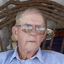

Robert Emanuel Ware
| Birth | : | 17 Dec 1928 Grenola, Elk County, Kansas, USA |
| Death | : | 16 Jan 2013 Moline, Elk County, Kansas, USA |
| Burial | : | Green Lawn Cemetery, Grenola, Elk County, USA |
| Coordinate | : | 37.3466988, -96.4364014 |
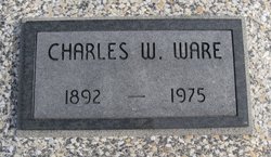
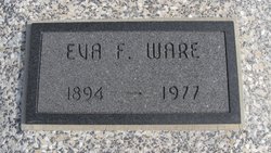
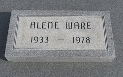
| Description | : | Robert Emanuel Ware, age 84, a resident of Moline, Kansas passed away Wednesday, January 16, 2013 at his home. He was born on December 17, 1928 in Grenola, Kansas the son of Charles Wilson and Eva Frances (Hankins) Ware. Robert was a lifelong farmer and rancher in Elk County. He was employed by Elk County Road Department for 26 years and was the road foreman for many of those years. He enjoyed woodworking and made many picture frames that he gave to family and friends. On November 8, 1949 he was united in marriage to Alene McGlasson and to this... Read More |
frequently asked questions (FAQ):
-
Where is Robert Emanuel Ware's memorial?
Robert Emanuel Ware's memorial is located at: Green Lawn Cemetery, Grenola, Elk County, USA.
-
When did Robert Emanuel Ware death?
Robert Emanuel Ware death on 16 Jan 2013 in Moline, Elk County, Kansas, USA
-
Where are the coordinates of the Robert Emanuel Ware's memorial?
Latitude: 37.3466988
Longitude: -96.4364014
Family Members:
Parent
Spouse
Siblings
Flowers:


Nearby Cemetories:
1. Green Lawn Cemetery
Grenola, Elk County, USA
Coordinate: 37.3466988, -96.4364014
2. Sallee Family Cemetery
Moline, Elk County, USA
Coordinate: 37.3634600, -96.3627900
3. Pleasant Valley Cemetery
Chautauqua County, USA
Coordinate: 37.2725296, -96.3998795
4. Moline Cemetery
Moline, Elk County, USA
Coordinate: 37.3746986, -96.3094025
5. Old Boston Cemetery
Chautauqua County, USA
Coordinate: 37.2986540, -96.3174390
6. Mount Olivet Cemetery
Moline, Elk County, USA
Coordinate: 37.3527985, -96.2893982
7. Belknap Cemetery
Chautauqua County, USA
Coordinate: 37.2508316, -96.3459778
8. Old Cloverdale Cemetery
Chautauqua County, USA
Coordinate: 37.2206001, -96.4756012
9. Ames Chapel Cemetery
Moline, Elk County, USA
Coordinate: 37.3147011, -96.2727966
10. Caneyville Cemetery
Cedar Vale, Chautauqua County, USA
Coordinate: 37.2142200, -96.4982700
11. Clear Creek Cemetery
Howard, Elk County, USA
Coordinate: 37.4874992, -96.4171982
12. Hilltop Cemetery
Cowley County, USA
Coordinate: 37.3229900, -96.6308400
13. Glen Grouse Cemetery
Cowley County, USA
Coordinate: 37.4617004, -96.5858002
14. Box Cemetery
Atlanta, Cowley County, USA
Coordinate: 37.4067800, -96.6365200
15. Grace Lawn Cemetery
Howard, Elk County, USA
Coordinate: 37.4583015, -96.2722015
16. Otter Creek Cemetery
Cowley County, USA
Coordinate: 37.1977700, -96.5475800
17. South Prairie Cemetery
Cowley County, USA
Coordinate: 37.2597008, -96.6256027
18. Lazette Cemetery
Cowley County, USA
Coordinate: 37.3459200, -96.6657200
19. Round Mound Cemetery
Cedar Vale, Chautauqua County, USA
Coordinate: 37.1632614, -96.3995438
20. Elk Falls Cemetery
Elk Falls, Elk County, USA
Coordinate: 37.3767100, -96.2005400
21. Cambridge Cemetery
Cambridge, Cowley County, USA
Coordinate: 37.3114014, -96.6791992
22. Forest Cemetery
Howard, Elk County, USA
Coordinate: 37.5416985, -96.3796997
23. Spring Creek Cemetery
Chautauqua County, USA
Coordinate: 37.1856003, -96.2842026
24. Mount Vernon Cemetery North
Atlanta, Cowley County, USA
Coordinate: 37.4025002, -96.6908035