

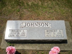
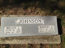
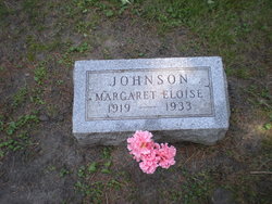
Robert George “Bob” Johnson
| Birth | : | 21 Oct 1911 Hardin County, Iowa, USA |
| Death | : | 1 Aug 2003 Eldora, Hardin County, Iowa, USA |
| Burial | : | Mount Perry Cemetery, Mount Perry, North Burnett Region, Australia |
| Coordinate | : | -25.1844540, 151.6523560 |
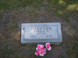
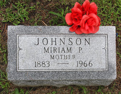
| Description | : | Robert "Bob" Johnson By: 08/06/2003 October 21, 1911-August 1, 2003 IOW A FALLS - Robert "Bob" George Johnson, 91, of Iowa Falls, formerly of Latimer, died Saturday, Aug. 1, 2003, at the Valley View Nursing Center, Eldora. Private family graveside inurnment of his cremated remains will be held at Union Cemetery, Iowa Falls. Memorials may directed to the First Congregation Church, 520 College Ave., Iowa Falls, IA 50126. R obert was born Oct. 21, 1911, on Sunnyside Farm, south of Iowa Falls, to Warren T. and Miriam Pyle Johnson. In 1915, the family moved to Oaklawn Farm five miles southeast... Read More |
frequently asked questions (FAQ):
-
Where is Robert George “Bob” Johnson's memorial?
Robert George “Bob” Johnson's memorial is located at: Mount Perry Cemetery, Mount Perry, North Burnett Region, Australia.
-
When did Robert George “Bob” Johnson death?
Robert George “Bob” Johnson death on 1 Aug 2003 in Eldora, Hardin County, Iowa, USA
-
Where are the coordinates of the Robert George “Bob” Johnson's memorial?
Latitude: -25.1844540
Longitude: 151.6523560
Family Members:
Parent
Spouse
Siblings
Flowers:


Nearby Cemetories:
1. Mount Perry Cemetery
Mount Perry, North Burnett Region, Australia
Coordinate: -25.1844540, 151.6523560
2. Boolboonda Cemetery
Boolboonda, Bundaberg Region, Australia
Coordinate: -25.0652000, 151.6921200
3. Walla Station Cemetery
Gin Gin, Bundaberg Region, Australia
Coordinate: -25.1250040, 151.9782540
4. Gin Gin Cemetery
Gin Gin, Bundaberg Region, Australia
Coordinate: -24.9966870, 151.9487120
5. Booyal Cemetery
Booyal, Bundaberg Region, Australia
Coordinate: -25.1758160, 152.0520170
6. Chowey Cemetery
Chowey, North Burnett Region, Australia
Coordinate: -25.4513533, 151.9287490
7. Binjour Cemetery
Binjour, North Burnett Region, Australia
Coordinate: -25.3074300, 151.2626200
8. Degilbo Cemetery
Degilbo, North Burnett Region, Australia
Coordinate: -25.4774440, 151.9982160
9. Gayndah Cemetery
Gayndah, North Burnett Region, Australia
Coordinate: -25.6310400, 151.6143200
10. Coalstoun Lakes Cemetery
Coalstoun Lakes, North Burnett Region, Australia
Coordinate: -25.6147010, 151.8871120
11. Philips Private Cemetery
Pine Creek, Bundaberg Region, Australia
Coordinate: -25.0532680, 152.1633390
12. South Kolan Cemetery
South Kolan, Bundaberg Region, Australia
Coordinate: -24.9390920, 152.1427140
13. Cordalba Cemetery
Cordalba, Bundaberg Region, Australia
Coordinate: -25.1562560, 152.2146830
14. Mulgildie Cemetery
Mulgildie, North Burnett Region, Australia
Coordinate: -24.9688690, 151.1355900
15. Mundubbera Cemetery
Mundubbera, North Burnett Region, Australia
Coordinate: -25.6057882, 151.3107160
16. Apostolic Church of Queensland Cemetery Malmoe
O'Bil Bil, North Burnett Region, Australia
Coordinate: -25.5445737, 151.2313607
17. Eidsvold Cemetery
Eidsvold, North Burnett Region, Australia
Coordinate: -25.3948440, 151.1182060
18. Apple Tree Creek Cemetery
Apple Tree Creek, Bundaberg Region, Australia
Coordinate: -25.2254030, 152.2386650
19. Agnes Vale Station Cemetery
Childers, Bundaberg Region, Australia
Coordinate: -25.2720660, 152.2496070
20. Childers Lawn Cemetery
Childers, Bundaberg Region, Australia
Coordinate: -25.2241618, 152.2642764
21. Monto Cemetery
Monto, North Burnett Region, Australia
Coordinate: -24.8481228, 151.1401369
22. Rosedale Cemetery
Rosedale, Gladstone Region, Australia
Coordinate: -24.6180630, 151.9158230
23. Avondale Independent Cemetery
Rockhampton Region, Australia
Coordinate: -24.7368700, 152.1627900
24. Bundaberg Crematorium and Memorial Park
Bundaberg, Bundaberg Region, Australia
Coordinate: -24.9131630, 152.2998890