Robert Gordon Field
| Birth | : | 22 Jul 1922 Milton, Cabell County, West Virginia, USA |
| Death | : | 26 Nov 1953 Huntington, Cabell County, West Virginia, USA |
| Burial | : | Poplar Springs Baptist Cemetery, State Road, Surry County, USA |
| Coordinate | : | 36.3107780, -80.8358500 |
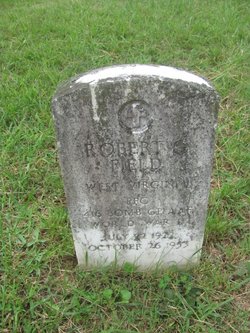
| Inscription | : | ROBERT G FIELD WEST VIRGINIA PFC 416 BOMB GP AAF WORLD WAR II JULY 22 1922 OCTOBER 26 1953 |
| Description | : | AUTO WRECK VICTIM DIES Cabell County counted its 18th traffic fatality of the year yesterday with the death of Robert G. Field, 31, of 1351 Jefferson Avenue. The salesman for the Electrolux Corp. suffered a brain injury Monday when his automobile went out of control in a highway cut on U. S. Route 60 near the Fudge's Creek bridge. The car climbed an embankment and Mr. Field was thrown out. He died at 12:20 A. M. in a Huntington hospital. Funeral services will be conducted Sunday at 2 P. M. at the home of his mother, Mrs. Vena Field of... Read More |
frequently asked questions (FAQ):
-
Where is Robert Gordon Field's memorial?
Robert Gordon Field's memorial is located at: Poplar Springs Baptist Cemetery, State Road, Surry County, USA.
-
When did Robert Gordon Field death?
Robert Gordon Field death on 26 Nov 1953 in Huntington, Cabell County, West Virginia, USA
-
Where are the coordinates of the Robert Gordon Field's memorial?
Latitude: 36.3107780
Longitude: -80.8358500
Family Members:
Parent
Siblings
Flowers:
Nearby Cemetories:
1. Poplar Springs Baptist Cemetery
State Road, Surry County, USA
Coordinate: 36.3107780, -80.8358500
2. Guyer Family Cemetery
Poplar Springs, Surry County, USA
Coordinate: 36.3112820, -80.8358360
3. Rigsby-Ray Cemetery
Elkin, Surry County, USA
Coordinate: 36.3067000, -80.8414200
4. Eldridge Family Cemetery
Elkin, Surry County, USA
Coordinate: 36.3089260, -80.8227040
5. Crestwood Memorial Gardens
State Road, Surry County, USA
Coordinate: 36.3153076, -80.8590851
6. Grassy Creek Methodist Church Cemetery
Elkin, Surry County, USA
Coordinate: 36.2976112, -80.8575592
7. Ebenezer United Methodist Cemetery
Elkin, Surry County, USA
Coordinate: 36.2879448, -80.8231125
8. Jackson-Roberts Cemetery
Elkin, Surry County, USA
Coordinate: 36.2831930, -80.8333580
9. Mulberry Primitive Baptist Church Cemetery
Mulberry, Surry County, USA
Coordinate: 36.3258210, -80.8045120
10. Welborn Family Cemetery
Elkin, Surry County, USA
Coordinate: 36.2938330, -80.8054440
11. Mount Pleasant Baptist Church Cemetery
State Road, Surry County, USA
Coordinate: 36.3289030, -80.8670950
12. Gentry Family Cemetery
Elkin, Surry County, USA
Coordinate: 36.2874170, -80.8640740
13. Oak Grove Cemetery
Elkin, Surry County, USA
Coordinate: 36.2794000, -80.8203000
14. Welcome Valley Baptist Cemetery
Elkin, Surry County, USA
Coordinate: 36.3161390, -80.7932220
15. Bessies Chapel Baptist Church Cemetery
Mulberry, Surry County, USA
Coordinate: 36.3329460, -80.8001340
16. Jones Graveyard
Elkin, Surry County, USA
Coordinate: 36.2981960, -80.7930710
17. Golden Family Cemetery
State Road, Surry County, USA
Coordinate: 36.3439700, -80.8567300
18. Swift Family Cemetery
Mountain Park, Surry County, USA
Coordinate: 36.3474731, -80.8469162
19. Elkin Valley Baptist Church Cemetery
Elkin, Surry County, USA
Coordinate: 36.2734250, -80.8513320
20. Central Full Gospel Church Cemetery
State Road, Surry County, USA
Coordinate: 36.3346252, -80.8777466
21. Cockerham Graveyard
Mountain Park, Surry County, USA
Coordinate: 36.3518100, -80.8540160
22. Laster Wall Cemetery
Elkin, Surry County, USA
Coordinate: 36.3557222, -80.8224722
23. Hughs Cockerham Family Cemetery
Mulberry, Surry County, USA
Coordinate: 36.3121770, -80.7779970
24. Moody Family Cemetery
State Road, Surry County, USA
Coordinate: 36.3382510, -80.8846200

