
| Birth | : | 1815 County Wexford, Ireland |
| Death | : | 15 May 1890 Ashton, Ottawa Municipality, Ontario, Canada |
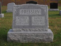
| Burial | : | Dewar Cemetery, Beckwith, Lanark County, Canada |
| Coordinate | : | 45.1325500, -76.0333900 |
| Description | : | From Motabower Townland, County Wexford, Ireland. In 1839, the tenant list of the massive Coolattin Estate in Co. Wicklow, Ireland (owned by Lord Earl Fitzwilliam) listed Robert, age 24, farmer, living with his wife (Susan, age 25), father Joseph (age 67), and 1 male child (his son, Joseph). In 1847, Robert and his wife Susan were again on the tenant list of the Coolattin Estate, along with their children Joseph, Henry, William, and Rachel (ages 2-9), and Robert's sister Henrietta. It was the time of the Great Famine in Ireland (1845-1849), with mass starvation and tenants unable to... Read More |
frequently asked questions (FAQ):
-
Where is Robert Prestley's memorial?
Robert Prestley's memorial is located at: Dewar Cemetery, Beckwith, Lanark County, Canada.
-
When did Robert Prestley death?
Robert Prestley death on 15 May 1890 in Ashton, Ottawa Municipality, Ontario, Canada
-
Where are the coordinates of the Robert Prestley's memorial?
Latitude: 45.1325500
Longitude: -76.0333900
Family Members:
Flowers:


Nearby Cemetories:
1. Dewar Cemetery
Beckwith, Lanark County, Canada
Coordinate: 45.1325500, -76.0333900
2. Kennedy Cemetery
Beckwith, Lanark County, Canada
Coordinate: 45.1324920, -76.0344890
3. Christ Church Anglican Cemetery
Ashton, Ottawa Municipality, Canada
Coordinate: 45.1582110, -76.0307590
4. United Cemeteries
Beckwith, Lanark County, Canada
Coordinate: 45.1410550, -76.0799730
5. Prospect United Church Cemetery
Prospect, Lanark County, Canada
Coordinate: 45.0973820, -75.9824840
6. Saint Augustine's Anglican Cemetery
Prospect, Lanark County, Canada
Coordinate: 45.1016510, -75.9751260
7. Baird Family Plot
Carleton Place, Lanark County, Canada
Coordinate: 45.1659683, -76.1214453
8. Munster Union Cemetery
Munster, Ottawa Municipality, Canada
Coordinate: 45.1663400, -75.9397700
9. Morphy Family Burying Ground
Carleton Place, Lanark County, Canada
Coordinate: 45.1383090, -76.1465250
10. Willis Family Cemetery
Carleton Place, Lanark County, Canada
Coordinate: 45.1317640, -76.1508170
11. St. Clare's Roman Catholic Cemetery
Ottawa, Ottawa Municipality, Canada
Coordinate: 45.1067760, -75.9215970
12. Saint James Cemetery
Carleton Place, Lanark County, Canada
Coordinate: 45.1571400, -76.1472900
13. Franktown Public Cemetery
Franktown, Lanark County, Canada
Coordinate: 45.0494280, -76.0551910
14. Shillington Cemetery
Munster, Ottawa Municipality, Canada
Coordinate: 45.1629900, -75.9177800
15. Saint Mary's Roman Catholic Cemetery
Beckwith, Lanark County, Canada
Coordinate: 45.1288890, -76.1716670
16. Dwyer Hill Pioneer Catholic Cemetery
Dwyer Hill, Ottawa Municipality, Canada
Coordinate: 45.0899140, -75.8969100
17. Sinclair Pioneer Cemetery
Carleton Place, Lanark County, Canada
Coordinate: 45.0689030, -76.1891210
18. Tennyson-McGregor Cemetery
Drummond, Lanark County, Canada
Coordinate: 45.0364720, -76.1603360
19. Wesleyan Methodist Cemetery
Mississippi Mills, Lanark County, Canada
Coordinate: 45.2081040, -76.1889840
20. Saint Thomas Anglican Cemetery
Stanley Corners, Ottawa Municipality, Canada
Coordinate: 45.2342200, -75.9058100
21. Saint Marys Roman Catholic Cemetery
Almonte, Lanark County, Canada
Coordinate: 45.2119800, -76.1931000
22. Stittsville United Church Cemetery
Stittsville, Ottawa Municipality, Canada
Coordinate: 45.2483230, -75.9122510
23. Saint Mary's Roman Catholic Cemetery Old
Almonte, Lanark County, Canada
Coordinate: 45.2449920, -76.1645940
24. Christ Church Pioneer Cemetery
Montague, Lanark County, Canada
Coordinate: 45.0025270, -75.9364830