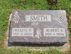
Robert Samuel Smith
| Birth | : | 13 Apr 1920 Talmage, Otoe County, Nebraska, USA |
| Death | : | 8 Sep 2006 Auburn, Nemaha County, Nebraska, USA |
| Burial | : | Roser Community Church Memorial Garden, Manatee County, USA |
| Coordinate | : | 27.5317000, -82.7332000 |
| Plot | : | Block 10, Lot 5, Space 10 |
| Description | : | His parents were Samuel A. and Evagene (France) Smith. He was baptized and confirmed at the Talmage Methodist Church. and graduated from high school in Talmage, NE. in 1938. He went on to receive his B.S. in Education at Peru State College in 1942 and in 1955 earned his Masters in Education from the Univ. of NE. in Lincoln, NE. He married Jan. 28, 1943 to Maxine H. Sherstad at Faith Lutheran Church in Talmage, NE. Robert enlised in the U.S. Navy in 1942, and served as a Navy Aviator for 5 1/2 years. Honorably... Read More |
frequently asked questions (FAQ):
-
Where is Robert Samuel Smith's memorial?
Robert Samuel Smith's memorial is located at: Roser Community Church Memorial Garden, Manatee County, USA.
-
When did Robert Samuel Smith death?
Robert Samuel Smith death on 8 Sep 2006 in Auburn, Nemaha County, Nebraska, USA
-
Where are the coordinates of the Robert Samuel Smith's memorial?
Latitude: 27.5317000
Longitude: -82.7332000
Family Members:
Parent
Spouse
Siblings
Children
Flowers:
Nearby Cemetories:
1. Roser Community Church Memorial Garden
Manatee County, USA
Coordinate: 27.5317000, -82.7332000
2. Gloria Dei Lutheran Church Memorial Garden
Holmes Beach, Manatee County, USA
Coordinate: 27.5155000, -82.7192000
3. Church of the Annunciation Memorial Garden
Holmes Beach, Manatee County, USA
Coordinate: 27.5001610, -82.7131040
4. Light House Cemetery
Sun City, Hillsborough County, USA
Coordinate: 27.6000420, -82.7603210
5. Fort Dade Post Cemetery
Hillsborough County, USA
Coordinate: 27.6006500, -82.7613000
6. Palma Sola Cemetery
Bradenton, Manatee County, USA
Coordinate: 27.5076000, -82.6478000
7. Memorial Gardens at Saints Peter and Paul
Bradenton, Manatee County, USA
Coordinate: 27.4760000, -82.6378000
8. Redeemer Lutheran Church Memorial Garden
Bradenton, Manatee County, USA
Coordinate: 27.4973060, -82.6251600
9. Fogartyville Cemetery
Bradenton, Manatee County, USA
Coordinate: 27.5030190, -82.6049000
10. Adams and Rogers Cemetery
Bradenton, Manatee County, USA
Coordinate: 27.5022570, -82.6028320
11. Kirkwood Presbyterian Church Memorial Garden
Bradenton, Manatee County, USA
Coordinate: 27.4617750, -82.6225730
12. Christ Episcopal Church Garden
Bradenton, Manatee County, USA
Coordinate: 27.4965000, -82.6018000
13. Saint Mary's Episcopal Church Memorial Garden
Palmetto, Manatee County, USA
Coordinate: 27.5220000, -82.5928000
14. Trinity United Methodist Church Memorial Garden
Bradenton, Manatee County, USA
Coordinate: 27.4963870, -82.5938530
15. Wesleyan Presbyterian Church Memorial Garden
Bradenton, Manatee County, USA
Coordinate: 27.4821880, -82.5928200
16. Palmetto Cemetery
Palmetto, Manatee County, USA
Coordinate: 27.5200900, -82.5810100
17. Old Palmetto Cemetery
Manatee County, USA
Coordinate: 27.5154890, -82.5807520
18. Saint Joseph Catholic Church Memorial Garden
Bradenton, Manatee County, USA
Coordinate: 27.4731000, -82.5882000
19. Lee Family Cemetery
Bradenton, Manatee County, USA
Coordinate: 27.4986095, -82.5749969
20. Sacred Heart RC Church Garden of Tranquility
Bradenton, Manatee County, USA
Coordinate: 27.4885000, -82.5765000
21. Holy Cross Catholic Church Garden of Peace
Palmetto, Manatee County, USA
Coordinate: 27.5364600, -82.5681200
22. New Memphis Cemetery
Palmetto, Manatee County, USA
Coordinate: 27.5347000, -82.5658000
23. Prayer Gardens of Bethel Baptist Church
Bradenton, Manatee County, USA
Coordinate: 27.4725170, -82.5793180
24. Old Memphis Cemetery
Palmetto, Manatee County, USA
Coordinate: 27.5362000, -82.5649000


